Flood warningAutomated flash-flood phone alert system developed
A part of Texas is called Flash Flood Alley because of the frequency and ferocity of flash floods; it stretches from San Antonio through Austin and to Dallas, and includes the Fort Hood military base; researchers develop a system which uses cell phones to give real-time text alerts of flash floods in the area
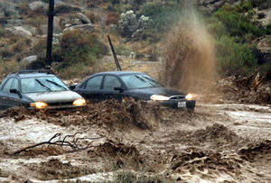
Flash floods appear suddenly, and are gone // Source: noaa.gov
Taking precautions for flooding during the worst drought in Texas history may seem unrealistic, but you may want to look at what happened in the Temple/Belton area in 2010.
Dr. June Wolfe, a Texas Agrilife Research scientist based in Temple, was been asked to do just that by local city officials after the flood. The result an automated weather station that sends text alerts to authorities to possible flooding of low-water crossings and danger to local communities. Local communities were reminded of the fact that they are located in what is called Flash Flood Alley in September 2010, when Tropical Storm Hermine brought from 7 to 8 inches of rain in less than 12 hours. No lives were lost during the 2010 flood, but Nolan Creek, which runs through Belton, turned into Nolan River.
The Belton Journal reported on 1 October 2010, that “a total of 289 total structures were impacted in some way. Of that figure, 29 residences were destroyed, 45 sustained major damage, 56 had minimum damage and 149 were affected.”
Those figures did not include submerged cars, and damage done to parks and streets. One report posited that the reason there were not more vehicles lost – or lives – was that the flood occurred in the early morning when there were not many people on the roads.
A Texas A&M release reports that when approached by Belton city officials, Wolfe and his research assistant, Tony Owen, had years of experience dealing with automated flood-monitoring on the Fort Hood reservations. The Flash Flood Alley region stretches from San Antonio through Austin and to Dallas, also includes the Fort Hood military base, Wolfe said.
Fort Hood comprises more than 300 square miles of Central Texas, and it has many unimproved low water crossings.
The U.S. Army was concerned about the historic loss of equipment and lives, both by civilian employees and military personnel on “tactical and paved” roads during flash floods.
Wolfe’s work with flood monitoring occurred serendipitously in 2002, when he was project manager for a water-quality study at the fort. The region is prone to severe soil erosion, and purpose of the study was to monitor sediment levels in rivers and streams with data logging devices. When a military team was inspecting the loss of a tank and crew at a low-water crossing, they learned that Wolfe’s sediment data loggers also had records of stream depth and flow at the time the accident.