Busy hurricane season ahead for U.S.
Forecasting organizations predicts that the coming hurricane season in the United States will see 15 named storms, 8 hurricanes, and 4 intense hurricanes (category 3 or greater); these 2011 forecast numbers are above the long-term (1950-2010) averages of 12 named storms, 7 hurricanes, and 3 intense hurricanes

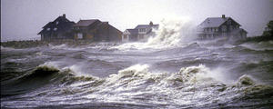
Hurricanes are a regular threat along the Atlantic coast // Source: nassauredcross.org
Andover, Massachusetts-based WSI (Weather Services International) describes itself as the world’s leading provider of weather-driven business solutions for professionals in the energy, insurance, aviation and media markets (the company owns the Weather Channel). The company also says that it has outperformed other, primary public forecasters on named storms by 25 percent since 2006.
WSI now predicts 15 named storms, 8 hurricanes, and 4 intense hurricanes (category 3 or greater). These 2011 forecast numbers are above the long-term (1950-2010) averages of 12 named storms, 7 hurricanes, and 3 intense hurricanes and match the averages from the more active recent period (1995-2010) of 15/8/4. The current forecast is a reduction from the previous forecast made in December for 17 named storms, 9 hurricanes, and 5 intense hurricanes.
“We have reduced our forecast numbers to ‘active-normal’ levels since the recent North Atlantic weather pattern has resulted in a cooling of the tropical Atlantic sea surface temperatures. Further, the La Nina event weakened a bit more quickly than we first expected, reducing the possibility of a favorable wind shear environment during the upcoming tropical season,” said WSI Chief Meteorologist Dr. Todd Crawford. “We do expect another active season in 2011, although not to the level of 2005 or 2010. However, while we expect less overall activity this year, we do expect a much more impactful season along the U.S. coastline. The U.S. has been spared from any landfalling hurricanes since 2008, and the hurricane drought in 2009 and 2010 is relatively rare in the historical record. In fact, the US has not had a three-year stretch without a hurricane landfall since the 1860s. Further, 80 percent of all years in the historical dataset have had at least one hurricane landfall in the US. Our recent good fortune in avoiding landfalling hurricanes is not likely to last.”
Crawford also indicated that the Gulf Coast was under a significant threat for hurricane landfall in the upcoming season.
The lack of U.S. landfalls in 2010 was primarily due to a persistent western Atlantic trough that essentially protected the U.S. East Coast from any direct hits. We do not expect this feature to be in place this year during late summer and fall when most tropical storms occur. Further, the Gulf and Caribbean sea surface temperatures are particularly warm this year, and we expect more development in these regions and less in the eastern tropical Atlantic. Storms developing in the Gulf and Caribbean are a much greater threat to make landfall along the U.S. coast than those that develop off the coast of Africa. For this reason, and since our hurricane landfall prediction model suggests sharply increased chances of U.S. landfall in 2011, especially in the western Gulf states, we expect two or three landfalling hurricanes this season. This is not particularly unusual, since historically 43% of years have had multiple hurricane landfalls. The forecast numbers from our model are quite similar to those prior to the 2008 season, when Hurricanes Dolly, Gustav, and Ike impacted Louisiana and Texas.
WSI’s next seasonal forecast update, which will include forecasts for summer temperatures, will be issued on 24 May. The next update for the 2011 tropical season will be released on 25 May.
