WaterFloating sensors to monitor water systems
The Floating Sensor Network project at UC Berkeley is building a water monitoring system that can be deployed in estuarine environments and rivers, and can be integrated into existing water-monitoring infrastructure
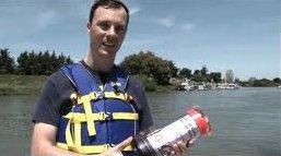
Berkeley graduate student with one of the floating sensors // Source: berkeley.edu
On Wednesday, the University of California, Berkeley Floating Sensor Network fleet conducted a major experiment and public demonstration.
The Floating Sensor Network project at UC Berkeley is building a water monitoring system that can be deployed in estuarine environments and rivers, and can be integrated into existing water-monitoring infrastructure.
Water managers need to track the movement of water, salinity, and other contaminants in complex networks of channels like deltas or estuaries. Whether in emergency situations such as a levee failure, flood, or contaminant spill, or for management efforts such as maintaining the freshwater channel in Northern California’s Sacramento-San Joaquin Delta, is important to understand “where the water is going.” Permanently placed sensors alone are important tools, but they cannot be placed everywhere on a large complex network of water or levees, and they do not track water as it moves.
The Floating Sensor Network team will build 100 motorized drifters, which are communication-enabled and integrate numerous sensors, including GPS, temperature, and salinity. The fleet will be deployable rapidly, in response to unanticipated events such as floods, levee breaches, and contaminant spills. The team is also working on hydrodynamic models (one and two dimensional shallow-water equations) and inverse modeling algorithms (Ensemble Kalman Filtering and its extensions) to integrate these measurements in the models.
Jointly with the Lawrence Berkeley National Laboratories and the California Department of Water Resources, the Floating Sensor Network team is developing a computational infrastructure which will run online (Web-based), and integrate in real-time the measurements from static sensors (for example, USGS permanently deployed sensing stations), mobile measurements, and any other data feed available to us, to estimate river flow and contaminant propagation in real-time, using online measurements. The results will be available to users in the form of “water maps,” that show the motion of water in real-time, and corresponding transported quantities (such as salt).
— Read more in Sarah Yang, “Floating robots use GPS-enabled smartphones to track water flow”