Early tsunami warningJapan awards tsunami buoy contract to SAIC
The Japan Meteorological Agency (JMA) in Tokyo, Japan, has awarded (SAIC) a contract for the production and delivery of six SAIC Tsunami Buoy (STB) systems; the STB systems will be deployed at locations in the northwest Pacific Ocean approximately 200 nautical miles east of Sendai, Japan
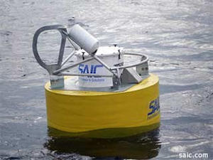
A deployed SAIC tsunami buoy // Source: saic.com
Science Applications International Corporation (SAIC) announced it has been awarded a contract for the production and delivery of six SAIC Tsunami Buoy (STB) systems by the Japan Meteorological Agency (JMA) in Tokyo, Japan.
The STB systems will be deployed at locations in the northwest Pacific Ocean approximately 200 nautical miles east of Sendai, Japan. The coastal region around Sendai experienced the brunt of the damage from the 2011 Tohoku earthquake and subsequent tsunami. SAIC notes that these STB systems represent part of a larger network of sensors deployed by the JMA which will provide the entire region with critical data to assess the magnitude of tsunamis generated in the oceans east of Japan. The addition of these systems into the existing sensor network will help strengthen the current warning system and provide a capability to directly assess tsunami waves in the deep sea.
“SAIC has successfully provided more than twenty tsunami assessment buoys to countries in the Western Pacific and Indian Ocean areas, forming the foundation of a global tsunami buoy network,” said Thomas Watson, SAIC senior vice president and business unit general manager. “We look forward to providing this proven technology to Japan to assist in strengthening their warning system after the terrible tragedy of 2011.”
The STB system consists of three subsystems: a surface communications buoy, a buoy mooring, and a bottom pressure recorder. The bottom pressure recorder includes a highly accurate sea floor pressure sensor which can detect earthquakes and sea level changes. Acoustic communications transmit the pressure data to the surface buoy, which then relays the data by satellite communications to forecast centers for analysis. Once processed, the data can provide real-time assessments of the characteristics of the tsunami in deep water. This data is then used with forecast models to predict the amplitude of the wave and inundation when it arrives at a particular coastal location.
In a statement released yesterday, JMA stated, “The deployment of these buoys will enable us to detect tsunamis generated around the Japan Trench axis off the Tohoku region about ten minutes after an earthquake. JMA will assist tsunami evacuation activities by issuing information on the offshore tsunami observations.”