WildfiresHelping communities resist wildfires
In the ten years since 2002, an annual average of nearly 71,000 wildfires near structures and other human development were recorded and 1.9 million hectares (4.7 million acres) burned; federal agencies spend an average of $1.2 billion per year on the suppression of these fires, with state and local agencies contributing millions more
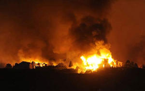
Homes being destroyed in Colorado's Waldo Canyon fire, June 2012 // Source: docbao.vn
Federal researchers have developed the first-ever rating system that allows communities to assess their risk from wildfires — on a building-by-building basis — and then ties that assessment to improved building codes, standards and practices that could help reduce the threat. The proposed Wildland Urban Interface (WUI) Hazard Scale addresses fires that occur where developed and undeveloped areas meet. It is described in a report* by the National Institute of Standards and Technology (NIST) in collaboration with the U.S. Forest Service (USFS).
The new scale joins others that help to express levels of risk from natural disasters — the Richter scale for earthquakes, the Saffir-Simpson for hurricanes and the Enhanced Fujita for tornados, according to NIST’s Alexander Maranghides, who created the new wildfire hazard assessment tool with William Mell of the USFS. “Now, we have proposed a scale specifically for wildland fires that will allow us to link exposure to improved codes and standards, and as a result, save lives, property and dollars,” Maranghides says.
A NIST release reports that the problem of WUI (USFS defines the wildland urban interface, or WUI, as an “area where structures and other human development meet or intermingle with undeveloped wildland or vegetative fuels”) fires, particularly in the western and southern regions of the United States, has been growing more prevalent as housing developments push into wilderness areas. According to the Bureau of Land Management’s National Interagency Fire Center (NIFC), the ten years since 2002 saw an annual average of nearly 71,000 WUI fires recorded and 1.9 million hectares (4.7 million acres) burned. The monetary toll from the destruction is staggering; the NIFC estimates that federal agencies spend an average of $1.2 billion per year on WUI fire suppression alone, with state and local agencies contributing millions more.
The WUI Hazard Scale developed by NIST and USFS is designed to consistently measure the expected risks from both fire and wind-blown embers during a WUI fire event for individual locations within a community, taking into account the ever-changing nature of those hazards.
“Wildfires are among the few natural disasters in which risk levels can rapidly change as the event progresses and the threat doesn’t weaken with distance away from a well-defined epicenter, as in a tornado,” Mell says. “If your home is nestled deep within a neighborhood away from the leading edge of a fire, you might not be at risk early on. However, the danger to your home dramatically increases if a neighboring house, the surrounding landscape or a nearby vehicle catches on fire.”
Fire behavior in the wildland urban interface is a function of fuel (both vegetation and structures), topography and local weather. The WUI Hazard Scale accounts for local and transient variations in these factors so that each specific location can be rated as to its susceptibility. The range of ratings can then be used to create a map of the different levels of risk throughout a community and pinpoint where protective measures or “hardening” of structures are most needed.
The release notes that field data and computer modeling of prescribed burns (controlled fires used in wildland management) were used to define the specifics of the fuel, topography and weather characteristics attributed to different “exposures”. To link the scale to a means of protecting communities, Maranghides and Mell have proposed four “building construction classes” defined for different risk zones in a mapped community.
“If homes and other buildings in the most susceptible zones can be built or retrofitted to high-risk standards, they could potentially serve as a ‘frontline defensive wall’ for the structures in the lower-risk zones they surround,” Maranghides explains. “In effect, we may be able to mitigate the entire dynamic of a WUI fire event if the frontline structures don’t ignite.”
NIST and USFS plan to collect additional data through field evaluations in a wide variety of communities and surveys of areas that have recently experienced WUI fires to further refine the WUI fire hazard scale. The two agencies also will be working with various public and private stakeholder groups toward acceptance and implementation of the proposed scale and building construction classes, with the goal of improving standards, codes and practices.
For more details, see the 5 December 2012, NIST release, “NIST and Forest Service Create World’s First Hazard Scale for Wildland Fires.”
* See A. Maranghides and W. Mell, Framework for Addressing the National Wildland Urban Interface Fire Problem — Determining Fire and Ember Exposure Zones using a WUI Hazard Scale (NIST Technical Note 1748) (2012)