FloodsSediment carried by 2011 Mississippi flood shored up Louisiana’s wetlands
The spring 2011 flood on the Mississippi was among the largest floods ever, the river swelling over its banks and wreaking destruction in the surrounding areas. A new study also shows, however, that the floods reaped environmental benefits — transporting and laying down new sediment in portions of the Delta — that may help maintain the area’s wetlands.
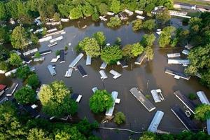
Along with the damage came a bolstering of the Mississippi delta // Source: jamnews.ir
The spring 2011 flood on the Mississippi was among the largest floods ever, the river swelling over its banks and wreaking destruction in the surrounding areas. A University of Pennsylvania-led study also shows, however, that the floods reaped environmental benefits — transporting and laying down new sediment in portions of the Delta — that may help maintain the area’s wetlands.
A University of Pennsylvania release reports that the study, led by Ph.D. student Nicole Khan of the Department of Earth and Environmental Science, is the first to quantify the amount of sediment transported to wetlands by a flood on the Mississippi. The results shed light on how floods impact wetlands, and how these effects might be harnessed to purposefully rebuild Louisiana’s wetlands, which are sinking from compaction and growing smaller as sea level rises.
Additional Penn authors in the Department of Earth and Environmental Science include Benjamin Horton, an associate professor and Khan’s advisor; Douglas Jerolmack, an assistant professor and Federico Falcini, formerly a postdoctoral researcher in Jerolmack’s lab and now a researcher at the Consiglio Nazionale delle Ricerche in Rome. The Penn geologists partnered on the research with Karen McKee of the U.S. Geological Survey, Mihaela Enache of the Academy of Natural Sciences of Drexel University and Christopher Vane of the British Geological Survey.
A study by many of the same scientists, published in Nature Geoscience last year, found that the 2011 Mississippi River floods deposited more sediment in the Atchafalaya River Basin, where the waters moved slowly over a broad area, than in the Mississippi River Basin, where levees and control structures funneled the floodwaters into a jet stream that shot water and sediment out into the Gulf of Mexico.
The current study, published in Geology, focuses specifically on the questions of how much sediment was laid down in the river basins affected by the flood and where the sediments deposited the most.
“The marshes may be able to maintain their surface area or height above sea level if they receive significant sediment, either from floods or hurricanes or normal fluvial processes,” Horton said. “Ours is the only empirical study to obtain an estimate of how much sediment is deposited by a large-scale flood on the Mississippi.”
To obtain this estimate, Khan and USGS researchers set out in June 2011 on a helicopter above the Louisiana wetlands. They landed