WildfiresWildfire science returns to California’s Rim Fire
The challenging job of managing wildfires rests with other agencies, but the U.S. Geological Survey (USGS) provides the underlying science for sound land management decisions, before, during, and after wildfires. The USGS role studying natural hazards such as floods, landslides, earthquakes, and volcanoes is well known, but fewer people are aware of the USGS scientific work in major wildfire events, which are one of the most regular and sometimes most devastating natural hazards in the West.
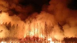
Trees ablaze during California's Rim Fire // Source: commons.wikimedia.org
Although dousing the flames was foremost in people’s minds during the recent Rim Fire in Stanislaus National Forest and Yosemite National Park, U.S. Geological Survey (USGS) scientific work continues well after the fire is out. USGS scientists are continuing their critical research characterizing the hidden dangers faced after large wildfires. A USGS release reports that while the fire was still smoldering in September, the multi-agency BAER (Burned Area Emergency Response) team developed a burn-severity map and shared it with USGS scientists. USGS assessed the potential for debris flows that tend to occur when the winter rains soak the steep slopes following fires by adding critical information on soil characteristics, the ruggedness of the terrain, and the typical amount of rainfall in that area in order to model the likelihood and possible volumes of debris flows. The just published Rim Fire debris-flow hazards assessment map, will help land and emergency managers focus mitigation treatments on where the greatest damage might be done by post-fire debris flows.
As the Rim Fire growth slowed and the BAER team began their onsite evaluation of post-fire threats to life and property, the USGS California Water Science Center and the San Francisco Public Utilities Commission (SFPUC), operator of the Hetch Hetchy Regional Water System, assessed project facilities and USGS streamgages within the fire perimeter. Many of these streamgages were scorched and in need of repair, and the facilities are now subject to increased potential of debris flows and flash flooding.
“Our ongoing science research and the relationships and collaborations we have built with wildfire responders and land managers help mitigate and reduce the hazards of wildfire in the future,” said USGS Pacific Regional Director Mark Sogge.
The release notes that the most time-critical task for USGS scientists now is to work with the California Department of Water Resources, Modesto Irrigation District, and Turlock Irrigation District to establish a streamgage and extensive water-quality monitoring at a location downstream from the fire extent and upstream from Don Pedro Reservoir in the Sierra Nevada foothills. Documenting the quantity and quality of water entering the reservoir, and modeling streamflow changes in response to the fire, gives reservoir managers the tools to understand the cumulative effects of the Rim Fire on future water supplies.
Throughout the fire, USGS satellite imagery, such as Landsat’s before-and-after images of the Rim Fire, provided firefighters with situational awareness, and helped them mount their campaign against the intense and fast flames. Maps and satellite imagery were a daily element of Integrated Fire Command briefings.
USGS says it continues to work with the California Department of Water Resources, the SFPUC, and the Don Pedro Reservoir managers to include the Rim Fire burn area data in, and thereby increase the utility of, hydrologic models currently being developed. Additional remote sensing information will be incorporated into the updated hydrologic model to help the managers understand the runoff and streamflow as it changes through the years after the fire.
USGS is also monitoring soil moisture and incorporating soil properties, burn severity, and expected rates of vegetation recovery into a computer model to understand the hydrologic processes, responses, and sensitivities of the burned areas to a range of potential climatic conditions in the next five years.
Although the challenging job of managing such fires rests with other agencies, USGS notes that it provides the underlying science for sound land management decisions, before, during, and after wildfires. The USGS role studying natural hazards such as floods, landslides, earthquakes, and volcanoes is well known, but fewer people are aware of the USGS scientific work in major wildfire events, which are one of the most regular and sometimes most devastating natural hazards in the West.
Well before the Rim Fire, USGS fire ecologists routinely provided scientific information to help state and federal agencies manage wildfire as a critical and natural ecosystem process and as a potential hazard to human life, property, and infrastructure in the Sierra Nevada as well as Southern California. A new video tells this story. USGS ecologists also monitor the effects of ash on wildlife.
USGS notes that these are only a few of the many ways the agency’s scientists and experts help to manage the tremendous potential for wildfire-related calamity in the West.