DisastersJapan tsunami exacerbated by landslide
The 2011 Japan tsunami, which killed up to 20,000 people and caused the partial meltdown of the Fukushima nuclear plant, was made worse by an underwater landslide, according to scientists. “The earthquake alone cannot explain the height of the waves along the Sanriku coast of northern Honshu Island,” says one scientist. “They were generated by a submarine landslide.” The research poses a big problem for early-warning systems, because where the risk of landslides goes unrecognized, tsunamis generated by similar earthquakes could be seriously underestimated.
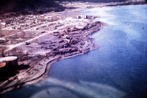
'Scalloped' shoreline indicates undersea landslides // Source: usgs.gov
The 2011 Japan tsunami, which killed up to 20,000 people and caused the partial meltdown of the Fukushima nuclear plant, was made worse by an underwater landslide, according to scientists.
Until now, the lethal waves have been blamed solely on the magnitude-nine earthquake which struck at sea, forty-three miles east of the country’s northern Tohoku peninsula.
An international team, led by Professor Dave Tappin of the Natural Environment Research Council’s (NERC) British Geological Survey, says the earthquake cannot explain the full extent of the waves.
“The earthquake alone cannot explain the height of the waves along the Sanriku coast of northern Honshu Island,” says Tappin. “They were generated by a submarine landslide.”
According to Tappin, the research raises a “big problem” for early-warning systems. Where the risk of landslides goes unrecognized, tsunamis generated by similar earthquakes could be badly underestimated.
It is well known that landslides can generate tsunamis on their own, and research on the Papua New Guinea event of 1998 showed that landsides triggered by small earthquakes could also produce devastating tsunamis.
This research, however, presented at last week’s Fall Meeting of the American Geophysical Union, is the first to recognize the significant contribution that underwater landslides can make to tsunamis generated by giant quakes.
“With the Japan tsunami, for the first time we had offshore wave data recorded at GPS buoys,” says Tappin. “This allowed us to identify the most likely location of the landslide.
“Using maps of the seabed, we identified a landslide that was 40 kilometers wide, 20 kilometers long and 2 kilometers thick. That makes it 500 cubic kilometers, so it’s pretty big.
“We then used computer models to simulate the tsunami from a dual source; the earthquake and the landslide, and this gave us the high water levels along the north Honshu coast.
“An additional check on the landslide source was from an analysis of the wave frequency at the buoys, which showed a high-frequency component that could only be from the landslide.”
Tappin says the landslide also explains helicopter video footage of the tsunami which appears to show two separate wave trains, around 20-30 minutes apart.
The earthquake hit on the afternoon of 11 March 2011. It was the most powerful ever known to have struck Japan, and was strong enough to shift the Earth slightly on its axis.
The sheer scale of the tsunami took Japan by surprise. The Japanese Meteorological Agency had predicted a tsunami of just six meters. When the waves arrived, however, they reached heights of up to twelve meters, overtopping seawalls and sweeping away entire towns behind them.
The Sanriku coastline was particularly hard-hit. In Minamisanriku, a town of 17,000 people, over 95 percent of the buildings were destroyed, and more than 800 people lost their lives.
This story is republished courtesy of Planet Earth online, a free, companion website to the award-winning magazine Planet Earth published and funded by the Natural Environment Research Council (NERC).