Earthquakes Understanding where tremblors are more likely to occur, helping communities prepare
Some of the world’s largest earthquakes occur on subduction zones, where a cold dense oceanic plate moves under a warmer continental plate. This was the case for the massive Tohoku earthquake in Japan in 2011, which was followed by a tsunami with waves up to thirty-three feet that left thousands dead and inflicted extensive damage to buildings and infrastructure, including four major nuclear power stations.
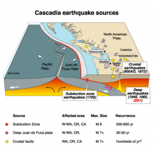
Plate movement of the Cascadia earthquake // Source: commons.wikimedia.org
Some of the world’s largest earthquakes occur on subduction zones, where a cold dense oceanic plate moves under a warmer continental plate. This was the case for the massive Tohoku earthquake in Japan in 2011, which was followed by a tsunami with waves up to thirty-three feet that left thousands dead and inflicted extensive damage to buildings and infrastructure, including four major nuclear power stations. Manoochehr Shirzaei, an assistant professor at ASU’s School of Earth and Space Exploration, and Jennifer Weston, a former postdoctoral researcher at the school, have published a new technique for observing the behavior of these destructive tectonic settings and forecasting earthquakes in the journal Tectonophysics. (Weston is now at the International Seismological Centre in England.)
ASU reports that Shirzaei and Weston used measurements of surface displacement with GPS, in combination with the location and magnitude of characteristically repeating earthquakes, to investigate how the Japan subduction zone was behaving prior to a large earthquake.
“We were trying to see if GPS and data on characteristically repeating earthquakes could be successfully combined to investigate the movement (creep) or lack of movement (locking) on the plate interface,” said Weston.
In their study, Weston and Shirzaei compared the location of areas of the subduction zone that were moving “fast” (8 cm/year) and “slow” (0-2 cm/year) with the location of certain properties of the subduction zone.
They began to see a link between the two that could help them understand why some parts of the subduction zone move relatively quickly but not very often, and why other parts move often but slowly (creep) in the period between large earthquakes.
Having an estimate of areas that are not creeping is useful for understanding where earthquakes are more likely to occur in the future.
“The Tohoku earthquake surprised the seismological community and challenged the conventional ideas about subduction zones behavior,” said Shirzaei. “This research provides unique data sets that update our understanding of these zones, and aid in the revision of earthquake forecast models, with the aim of avoiding future surprises.”
ASU notes that the research is unique in that it combined GPS and repeating earthquake data to look at subduction zones and used seismic tomography to solve for its mechanical properties. While these are different data sets, they are complementary. In addition, the researchers used a data set spanning most of the northeast Japan coast and over a period of nearly eight years.
“This information can be used to help communities be better prepared for a possible event,” said Weston. “And considering millions of people live adjacent to subduction zones, this is valuable information.”
— Read more in J. Weston and M. Shirzaei, “Combining GPS and repeating earthquakes for a high resolution analysis of subduction zone coupling,” Tectonophysics 667 (23 January 2016): 37–47 (doi:10.1016/j.tecto.2015.11.009)