-
Urgent action needed to save the Great Plains water supply
Significant portions of the Ogallala Aquifer, one of the largest bodies of water in the United States, are at risk of drying up if it continues to be drained at its current rate.The body of water, also known as the High Plains Aquifer, spans from Texas to South Dakota and drives much of the region’s economy. Scientists are proposing alternatives that will halt and hopefully reverse the unsustainable use of water drawdown in the aquifer.
-
-
Risk of earthquake/tsunami in Caribbean higher than previously thought
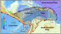
Enough strain may be currently stored in an earthquake zone near the island of Guadeloupe to cause a magnitude 8 or larger earthquake and subsequent tsunami in the Caribbean, according to a new U.S. Geological Survey study.
-
-
World's shrinking groundwater sources in urgent need of better governance

Groundwater makes up 97 per cent of the world’s available fresh water. Total global use is estimated by scientists at around 1,000 cubic kilometers a year, with the largest users being India, China, and the United States. Since 1900, the world has drawn down its groundwater reserves by an estimated 4,500 cubic kilometers — and demand continues to increase, especially in arid countries, which are rapidly running short of water that can be affordably extracted. Scientist has urged the world to take better care of its groundwater resources — or risk dangerous scarcities, economic impacts, and potential conflicts in coming decades.
-
-
NASA going asteroid hunting

The NASA Asteroid Robotic Retrieval Mission concept involves the capture of an asteroid, and dragging it onto a new trajectory that traps it in the Earth–Moon system where it will be further investigated by astronauts. The current mission design requires the target asteroid to have a diameter of seven to ten meters.
-
-
Sun not a key cause of climate change

Climate change has not been strongly influenced by variations in heat from the sun, a new scientific study shows. The findings overturn a widely held scientific view that lengthy periods of warm and cold weather in the past might have been caused by periodic fluctuations in solar activity.
-
-
Scientists predicted size, location of 2012 Costa Rica earthquake
The Nicoya Peninsula in Costa Rica is one of the few places where land sits atop the portion of a subduction zone where the Earth’s greatest earthquakes take place. Costa Rica’s location therefore makes it the perfect spot for learning how large earthquakes rupture. Because earthquakes greater than about magnitude 7.5 have occurred in this region roughly every fifty years, with the previous event striking in 1950, scientists have been preparing for this earthquake through a number of geophysical studies. The most recent study used GPS to map out the area along the fault storing energy for release in a large earthquake. The study accurately forecasted the size and location of the magnitude 7.6 Nicoya earthquake that occurred in 2012 in Costa Rica.
-
-
Freshwater loss compounds climate change’s detrimental effects on agriculture
A warmer world is expected to have severe consequences for global agriculture and food supply, reducing yields of major crops even as population and demand increases.Agricultural models estimate that given the present trajectory of greenhouse gas emissions, climate change will directly reduce food production from maize, soybeans, wheat, and rice by as much as 43 percent by the end of the twenty-first century. Now, a new analysis combining climate, agricultural, and hydrological models finds that shortages of freshwater used for irrigation could double the detrimental effects of climate change on agriculturedue to the reversion of twenty to sixty million hectares of currently irrigated fields back to rain-fed crops.
-
-
Sea level rise, shoreline changes leading influences on flooding from hurricanes
Recent studies into coastal flooding have focused on climate change impacts on the intensity and frequency of tropical cyclones themselves, but researchers say that two other factors contribute even more to the growing threats to coastal communities: sea level rise and shoreline retreat. Researchers highlight sea level rise and its potential dramatically to change the coastal landscape through shoreline erosion and barrier island degradation, and say that it is an under-appreciated and understudied factor that could lead to catastrophic changes in flood risk associated with tropical cyclones, known as hurricanes in the North Atlantic.
-
-
Asteroid hunter spacecraft returns first images after reactivation
In 2010 and early 2011, NASA’s Near-Earth Object Wide-field Infrared Survey Explorer (NEOWISE), a spacecraft that made the most comprehensive survey to date of asteroids and comets, discovered more than 34,000 asteroids and characterized 158,000 throughout the solar system. It was reactivated in September following thirty-one months in hibernation, to assist NASA’s efforts to identify the population of potentially hazardous near-Earth objects (NEOs).
-
-
Sandia to show Mine Rescue Robot at 2013 DARPA Robotics Challenge
Engineers from Sandia National Laboratories will demonstrate real-world robotics successes at the DARPA Robotics Challenge Trials 2013 Expo this week (20-21 December) in Florida. The challenge is focused on human-scaled robots that assist in humanitarian aid and disaster response. Sandia engineers will demonstrate the Gemini Scout Mine Rescue Robot, which was designed to overcome dangers lurking in a mining accident: poisonous gases, flooded tunnels, explosive vapors, and unstable walls and roofs. Such potentially deadly conditions and unknown obstacles can slow rescue efforts to a frustrating pace.
-
-
Japan tsunami exacerbated by landslide
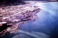
The 2011 Japan tsunami, which killed up to 20,000 people and caused the partial meltdown of the Fukushima nuclear plant, was made worse by an underwater landslide, according to scientists. “The earthquake alone cannot explain the height of the waves along the Sanriku coast of northern Honshu Island,” says one scientist. “They were generated by a submarine landslide.” The research poses a big problem for early-warning systems, because where the risk of landslides goes unrecognized, tsunamis generated by similar earthquakes could be seriously underestimated.
-
-
Enjoy it while you can: 850 million more years before oceans boil away

Scientists had estimated that the Earth’s oceans would boil away in about 150 million years. The reason: the sun expands as it runs out of hydrogen fuel, and that expansion, 150 million years from now,would cause “runaway” global warming leading to the boiling of the oceans. Scientists have now found that the Earth’s “Goldilocks Zone” — where it is neither too hot nor too cold for liquid to exist on a planet orbiting a star— is slightly larger than previously thought, meaning Earth has bought itself some additional time — about 700 million years – before the oceans evaporate.
-
-
Collapse of the universe closer than previously thought
Maybe it happens tomorrow. Maybe in a billion years. Physicists have long predicted that the universe may one day collapse, and that everything in it will be compressed to a small hard ball. New calculations by physicists now confirm this prediction — and they also conclude that the risk of a collapse is even greater than previously thought.
-
-
Post-Sandy study shows a polluted but largely intact barrier system off Long Island
As coastal communities continue to rebuild in the wake of Hurricane Sandy, scientists last week reported some encouraging news: The storm did not seriously damage the offshore barrier system that controls erosion on Long Island. Long-term concerns remain about the effects on the region of sea-level rise, pollutants churned up by the storm within back-barrier estuaries, and the damage closer to shore, but in the near-term, Long Island residents can rebuild knowing that Hurricane Sandy did not significantly alter the offshore barrier systems that control coastal erosion on the island.
-
-
Scrapping sea level protection puts Australian homes at risk
As the science on the coastal impacts of climate change gets stronger, the protections for Australia’s coastal communities are getting weaker. Along the eastern seaboard of Australia, where most Australians live, state governments are relaxing their policies and largely leaving it to local councils to decide if homes can be built in low-lying areas.Over the past fifty years, there have been twenty-five national inquiries and reports into coastal management. Those inquiries have overwhelmingly come to the conclusion that rather than leaving it to local councils, Australia needs one set of clear, national guidelines on coastal development and infrastructure. That is the opposite of what we are now seeing around Australia, with a mish-mash of different rules in different states. If that continues, everyone will pay.
-
The long view
Using Drone Swarms to Fight Forest Fires
Forest fires are becoming increasingly catastrophic across the world, accelerated by climate change. Researchers are using multiple swarms of drones to tackle natural disasters like forest fires.
How Climate Change Will Affect Conflict and U.S. Military Operations
“People talk about climate change as a threat multiplier,” said Karen Sudkamp, an associate director of the Infrastructure, Immigration, and Security Operations Program within the RAND Homeland Security Research Division. “But at what point do we need to start talking about the threat multiplier actually becoming a significant threat all its own?”