-
2016 hurricane season was a season of extremes
The 2016 hurricane season was the longest hurricane season since 1951, making it the second-longest hurricane season on record. “Overall 2016 was notable for a series of extremes, some rarely and a few never before observed in the Atlantic basin, a potential harbinger of seasons to come in the face of ongoing global climate change,” one researcher says.
-
-
Seacoast roads under new threat from rising sea level
Research has found that some roads, as far as two miles from the shore, are facing a new hazard that currently cannot be seen by drivers - rising groundwater caused by increasing ocean water levels. Without drastic improvements to these routes, at or below the pavement surface, motorists can expect segments of these roadways to deteriorate more quickly, require more maintenance and be closed for longer periods of time.
-
-
Mass trauma’s emotional toll can disrupt children’s sense of competence
Traumatic events can have a profound effect on communities. Whether it is a terrorist attack or a natural disaster, such as a hurricane or tornado, the aftermath can have lasting effects, especially on children. How children respond in the wake of mass traumatic events is related to their perceptions of competence – or how they view their ability to control a situation. An overwhelming challenge, such as a natural disaster or a terrorist attack, can disrupt the development of that sense of well-being.
-
-
Frequency of coastal flooding will double globally in next decades
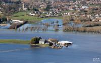
The frequency and severity of coastal flooding throughout the world will increase rapidly and eventually double in frequency over the coming decades even with only moderate amounts of sea level rise, according to a new study. The new report shows that with just 10 to 20 cm (4 to 8 inches) of sea level rise expected no later than 2050, coastal flooding will more than double. This dramatic increase in coastal flooding results from rising sea levels combined with storm-driven flooding, including the effects of waves and storm surge.
-
-
No funds for California's earthquake early-warning system in Trump's proposed budget
The Trump administration’s proposed budget would eliminate federal funding for an earthquake early warning system being developed for the U.S. West Coast. Critics say that if the relevant clauses in the budget proposal become law, the long-planned seismic warning effort will be killed. Scientists say the withdrawal of federal funds would likely end the early-warning project, which aims to send smartphone tremor alert messages to West Coast residents.
-
-
Israel to install earthquake early-warning system
Israel has selected Ottawa, Canada-based Nanometrics to build an earthquake early-warning system in Israel. The alert system will give a 10-to-30-second alert of an impending earthquake. The system’s success depends on the distinction between two types of waves an earthquake generates — P waves (for primary) and S waves (for secondary). P waves are very fast, traveling through rock at between four and seven kilometers per second, and are thus the first waves to arrive at a recording station following an earthquake. An S-wave has a shearing motion that makes the rock vibrate perpendicular to its path. This movement slows the S-wave, so that it travels at two to five kilometers per second, or about half the speed of the P-wave. It is S waves which are almost entirely responsible for the damage and destruction associated with earthquakes.
-
-
Drones help in better understanding of wildfires
U.S. Geological Survey scientists and partners are taking technology to the next level, using unmanned aircraft systems (UAS) to acquire both fire intensity and emissions data during prescribed burns. This effort combines expertise from multiple USGS partners that could reduce the harmful effects of smoke impacts from use of prescribed burns. Lessening the risk to property and lives during wildfires is a primary purpose of prescribed burns.
-
-
Knowing more and loosing less: Science and helps in disaster risk management
Natural and man-made disasters threaten millions of people every year and cause billions of property damage. How much do we know about them? And how can we use that knowledge to save lives and money? A recent report —Science for Disaster Risk Management 2017: Knowing More and Losing Less — seeks to answer these and other questions and to help prepare for the time when disaster strikes.
-
-
Weather disaster-prone countries do not spend more on weather services
Countries hit hardest by weather-related disasters do not necessarily spend more on commercial weather and climate information services that assist in preparing for these events, a new study finds. Identifying countries for which this is true and improving the design and delivery of weather and climate services in these locations could lead to better decision-making regarding risks and challenges, ultimately helping to save lives, protect infrastructure, and move people out of poverty.
-
-
Climate change likely to increase risk of costly storms in U.K.
The impact of climate change on the United Kingdom is likely to mean a higher number of more expensive wind storms, the insurance industry warned. New analysis done for the Association of British Insurers (ABI) shows temperature increases of just a small number of degrees are likely to lead to insurance losses for high winds which could be 11 percent, 23 percent, or even 25 percent higher nationwide.
-
-
Tornado’s strength explains number of casualties more than number of people in twister’s way
New research shows that the strength of a tornado has a significantly larger effect than population on the number of casualties. Using a regression model, researchers found that on average a doubling of the population under the path of a tornado leads to a 21 percent increase in the casualty rate, while a doubling of the energy dispersed by the tornado leads to a 33 percent increase in the casualty rate.
-
-
Creating high-speed internet lane for emergency situations
In a disaster, a delay can mean the difference between life and death. Emergency responders don’t have time to wait in traffic — even on the congested information superhighway. Researchers are developing a faster and more reliable way to send and receive large amounts of data through the internet. By a creating a new network protocol, called Multi Node Label Routing protocol, researchers are essentially developing a new high-speed lane of online traffic, specifically for emergency information.
-
-
AI to aid in humanitarian efforts
Mobile phones are one of the fastest growing technologies in the developing world with global penetration rates reaching 90 percent. However, the fact that most phones in developing countries are pre-paid means that the data lacks key information about the person carrying the phone, including gender and other demographic data, which could be useful in a crisis. Researchers have developed an AI algorithm to accurately predict the gender of pre-paid mobile phone users, so that emergency response teams would have better information about those affected by disasters.
-
-
Tornado damage impact could triple in coming decades
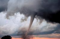
Tornadoes are one of the most unpredictable weather phenomena on Earth. Each year the United States, home to more tornadoes than any other country, sustains billions of dollars of damage, death, injuries, and disruption from the violent storms. Scientists say that the potential for annual tornado impact magnitude and disaster could triple by the end of the twenty-first century.
-
-
New tool could help predict, prevent surging waters in flood plains
A group of international scientists studying China’s Yellow River has created a new tool that could help officials better predict and prevent its all-too-frequent floods, which threaten as many as eighty million people. The tool — a formula to calculate sediment transport — may also be applied to studying the sustainability of eroding coastlines worldwide.
-
The long view
Strengthening School Violence Prevention
Violence by K-12 students is disturbingly common. Ensuring that schools have effective ways to identify and prevent such incidents is becoming increasingly important. Expanding intervention options and supporting K-12 school efforts in Behavioral Threat Assessment and Management (BTAM) would help.
Huge Areas May Face Possibly Fatal Heat Waves if Warming Continues
A new assessment warns that if Earth’s average temperature reaches 2 degrees C over the preindustrial average, widespread areas may become too hot during extreme heat events for many people to survive without artificial cooling.
Trump’s Cuts to Federal Wildfire Crews Could Have “Scary” Consequences
President Donald Trump’s moves to slash the federal workforce have gutted the ranks of wildland firefighters and support personnel, fire professionals warn, leaving communities to face deadly consequences when big blazes arrive this summer. States, tribes and fire chiefs are preparing for a fire season with minimal federal support.