-
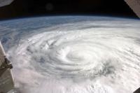
Near-normal Atlantic hurricane season is most likely this year: NOAA
NOAA’s Climate Prediction Center says the 2016 Atlantic hurricane season, which runs from 1 June through 30 November, will most likely be near-normal, but forecast uncertainty in the climate signals that influence the formation of Atlantic storms make predicting this season particularly difficult. NOAA predicts 70 percent likelihood of 10 to 16 named storms.
-
-
Groundwater extraction contributes less to sea level rise than previously thought
Groundwater extraction and other land water contribute about three times less to sea level rise than previous estimates, according to a new study. The study does not change the overall picture of future sea level rise, but provides a much more accurate understanding of the interactions between water on land, in the atmosphere, and the oceans, which could help to improve future models of sea level rise.
-
-
Changing climate threatens World Heritage, tourism sites
Climate change is fast becoming one of the most significant risks for World Heritage sites across the globe. Many World Heritage sites, designated for their global significance and universal value to humankind, are major tourist destinations. Some are among the most iconic places on Earth.
-
-
Improving hurricane intensity predictions through early use of “hurricane hunter” data
Data collected via airplane when a hurricane is developing can improve hurricane intensity predictions by up to 15 percent, according to researchers who have been working with the National Oceanic and Atmospheric Administration and the National Hurricane Center to put the new technique into practice.
-
-
A warning system for tsunamis
Right now, tsunami warning systems rely on region-specific scenarios based on previous patterns in that area. This is because scientists use sensors in the ocean, which can detect abnormal movements but cannot make accurate projections of how much water will hit a coast and how hard. But “most likely” is not a sure thing. Seismologists have created a new algorithm that could one day help give coastal cities early warning of incoming tsunamis.
-
-
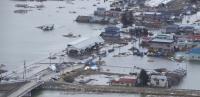
Flood preparedness: There’s a new USGS app for that
During the recent Texas flooding, the U.S. Geological Survey (USGS) unveiled a new tool that gives users real-time water, weather and National Weather Service flood forecast information all in one place. When water levels are rising, it can be hard to quickly get all the information you need about your area, especially when you are not in front of a computer.
-
-
Trump-owned resort cites sea level rise in application for seawall permit
Donald Trump may believe that the scientific evidence about global warming is a “hoax,” or the result of a Chinese plot to undermine the American economy, but the professional managers of his coastal properties believe that global warming is real, and that one of its consequences – sea level rise – poses a real threat to the Trump properties they manage.
-
-
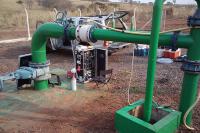
Update on earthquakes: Newest results from Oklahoma Commission look “encouraging”
The Oklahoma Corporation Commission (OCC), the regulatory agency overseeing the state’s oil and gas industry, now has data that may suggest their directives to owners of production and induction wells have successfully contributed to a decline in seismic activity in the most volatile areas prone to earthquakes.Scientists at the Oklahoma Geological Survey (OGS) continue to remind the public that there are a wide variety of unanswered questions about immediate and long-term remedies even with the new directives in place.
-
-
Exploring the unique relationship between fire and mankind
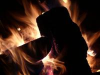
Fire has been an important part of the Earth System for over 350 million years, but humans are the only animals to have used and controlled fire. The complex interrelationships between fire and mankind transcend international borders and disciplinary boundaries. The specter of climate change highlights the need to improve our understanding of these relationships across space and time.
-
-
Japanese-language MyShake app crowdsources earthquake-shaking information
UC Berkeley scientists have released a Japanese version of an Android app that crowdsources ground-shaking information from smartphones to detect quakes and eventually warn users of impending jolts from nearby quakes. The app, called MyShake, became publicly available on Sunday. Since it was first released in English on 12 February 2016, more than 170,000 people have downloaded the app from around the world, and on any given day 11,000 phones provide data to the system.
-
-
Improving national resiliency: Joplin tornado 5th anniversary
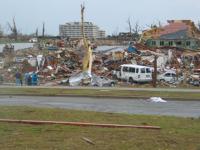
Disaster struck Joplin, Missouri, on 22 May 2011, when the deadliest and costliest single tornado in U.S. history left a 22-mile long path of destruction. The storm killed 161 people, destroyed some 8,000 structures, and left $2.8 billion in damages in its wake. In the five years since the tragedy, the National Institute of Standards and Technology (NIST) has led the effort to learn from the devastation and make improvements based on those lessons so that communities nationwide can become more resilient to tornadoes, significantly reducing both deaths and property damage.
-
-
Frequency of extreme heat waves on the increase in Africa -- could soon occur annually
Climate analysis shows that periods of unusually hot weather are on the rise for one of the most vulnerable continents to climate change, even if the increase in global average temperature remains at a modest level.Longer, hotter, more regular heat waves could have a damaging effect on life expectancy and crop production in Africa warn climate say scientists.
-
-
Seismic networks can serve as the backbone for 21st century firefighting
The same twenty-first century communications network used for real-time seismic monitoring in Nevada and parts of California can provide high-quality images to help first responders catch fires before they grow costly and dangerous. Experts say that seismic networks in place to provide earthquake early warning, if designed to sustain multi-hazard monitoring, can provide a robust data backbone for fire cameras that pan, tilt and zoom as they monitor wildfires and other extreme weather events like remote floods.
-
-
Humans have been causing earthquakes in Texas since the 1920s: Study
Earthquakes triggered by human activity have been happening in Texas since at least 1925, and they have been widespread throughout the state ever since, according to a new historical review of the evidence. The earthquakes are caused by oil and gas operations, but the specific production techniques behind these quakes have differed over the decades.
-
-
With drought easing, California rolls back water conservation rules
California announced on Wednesday that it was rolling back mandatory water conservation rules which were put in place at the height of a 4-year drought. The decision to roll back the restrictions came after water conditions in many parts of the state have improved as a result of a wet winter.
-
The long view
Strengthening School Violence Prevention
Violence by K-12 students is disturbingly common. Ensuring that schools have effective ways to identify and prevent such incidents is becoming increasingly important. Expanding intervention options and supporting K-12 school efforts in Behavioral Threat Assessment and Management (BTAM) would help.
Huge Areas May Face Possibly Fatal Heat Waves if Warming Continues
A new assessment warns that if Earth’s average temperature reaches 2 degrees C over the preindustrial average, widespread areas may become too hot during extreme heat events for many people to survive without artificial cooling.
Trump’s Cuts to Federal Wildfire Crews Could Have “Scary” Consequences
President Donald Trump’s moves to slash the federal workforce have gutted the ranks of wildland firefighters and support personnel, fire professionals warn, leaving communities to face deadly consequences when big blazes arrive this summer. States, tribes and fire chiefs are preparing for a fire season with minimal federal support.