-
Delaware prepares for sea-level rise
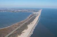
Benjamin Franklin said that that an ounce of prevention is worth a pound of cure, and Governor Jack Markell of Delaware agrees. Two weeks ago he unveiled an initiative aiming to prepare his state for the effects of climate change and sea-level rise. Markell has signed an executive order requiring all state agencies to take sea-level rise into account when designing and locating state projects. The order also requires development of strategies to make state facilities and operations better prepared to deal with climate change and sea-level rise.
-
-
Tiny smartphone sensors create an urban seismic network
A tiny chip used in smart phones to adjust the orientation of the screen could serve to create a real-time urban seismic network, easily increasing the amount of strong motion data collected during a large earthquake. This urban seismic network could transmit in real-time ground motion data to a central location for assessment. The rich volume of data could help first responders identify areas of greatest potential damage, allowing them to allocate resources more effectively.
-
-
Building disaster-relief phone apps on the fly
Researchers combine powerful new Web standards with the intuitive, graphical MIT App Inventor to aid relief workers with little programming expertise.
-
-
NYC enacts post-Sandy resiliency codes
Last week the New York City Council enacted laws implementing five recommendations of the Building Resiliency Task Force, led by Urban Green Council following Superstorm Sandy. This first package of laws makes NYC better prepared for future hurricanes and extreme weather.
-
-
NSF awards first coastal sustainability grants
More than half the world’s human population lived in coastal areas in the year 2000; that percentage is expected to rise to 75 percent by 2025. In wake of storms such as Hurricane Sandy, NSF grants will lead to better management of coastal environments.
-
-
How Sandy has changed storm warning procedures
Superstorm Sandy slammed against the U.S. Eastern Seaboard in October 2012, inundating iconic communities. Those communities have been rebuilding since then and things are almost back to normal for most. Something else, however, has had to be rebuilt as well: the structured procedures for issuing warnings. The goal is to help communities better comprehend what natural disasters will bring their doorsteps.
-
-
Fracking in Ohio: tapping a valuable resource or invading the environment?
A new study is examining methane and other components in groundwater wells, in advance of drilling for shale gas which is expected over the next several years in an Ohio region. A team of researchers spent a year doing periodic testing of groundwater wells in Carroll County, Ohio, a section of Ohio that sits along the shale-rich Pennsylvania-West Virginia borders. The study analyzed twenty-five groundwater wells at varying distances from proposed fracking sites in the rural, Appalachian, Utica Shale region of Carroll County.
-
-
Fracking does not cause quakes, but disposing water used in the process might: scientists
Researchers say that human activity associated with oil and gas production may sometimes cause earthquakes, but the problem lies in the disposal of drilling fluids in the underground injection wells, not hydraulic fracturing. The vast majority of injection wells do not cause quakes.
-
-
Los Alamos National Lab describes storm damage to affected New Mexico areas
Hours after a disaster declaration by Los Alamos County, Los Alamos National Laboratory officials on Friday described “millions” of dollars in damage to environmental monitoring stations, monitoring wells, access roads, and badly eroded canyon bottoms. “Last week we experienced an epic event,” said Dave McInroy, the laboratory’s program director for environmental corrective actions.
-
-
Deep earthquakes simulated in the laboratory
More than twenty years ago, researchers discovered a high-pressure failure mechanism that they proposed then was the long-sought mechanism of very deep earthquakes (earthquakes occurring at more than 400 km depth). The result was controversial because seismologists could not find a seismic signal in the Earth that could confirm the results. Seismologists have now found the critical evidence. Indeed, beneath Japan, they have even imaged the tell-tale evidence and showed that it coincides with the locations of deep earthquakes.
-
-
NIST announces five grants to pilot Trusted Identity technologies
The National Institute of Standards and Technology (NIST) has announced more than $7 million in grants to five organizations to fund pilot projects as part of the government’s National Strategy for Trusted Identities in Cyberspace (NSTIC) initiative. The NSTIC initiative is a collaborative effort among the private sector, advocacy groups and public-sector agencies to support technologies that enable individuals and organizations to use secure, efficient, convenient and interoperable identity credentials to access online services in a way that promotes confidence, privacy, choice and innovation.
-
-
California mulls costly earthquake early-warning system
The price of an early warning system which would alert California officials about an earthquake within sixty seconds before a major temblor strikes would be $80 million. The California legislature passed a bill on 13 September, requiring the state to develop the earthquake warning system, but it is unclear whether Governor Jerry Brown will sign the bill.
-
-
Aon calls on U.S. to extend expiring Terrorism Risk Insurance Act
Aon plc called on the U.S. government to extend the Terrorism Risk Insurance Act (TRIA), saying that TRIA remains the best solution for handling the terrorism insurance exposure in the United States. Aon says that if the program is allowed to expire, more than 85 percent of insurers will no longer continue to insure terrorism risk. Ultimately, in the unfortunate event of a large-scale attack, the U.S. government would face the full burden of the associated costs of said terrorism.
-
-
NASA, DHS to demonstrate disaster rescue tool
NASA and DHS are collaborating on a new radar device which detects heartbeats of victims trapped in wreckage. The device, known as the Finding Individuals for Disaster and Emergency Response (FINDER), can locate individuals buried under as much as thirty feet of crushed materials, hidden behind twenty feet of solid concrete, or from a distance of 100 feet in open spaces.
-
-
Flood insurance is not available to Canadian homeowners – should it be?
Canada is the only G8 country in which insurance against overland flooding is not available to homeowners — but does it have to remain that way? A study released Monday explores issues related to flooding and property insurance, aiming to advance informed discussion of the potential better to protect Canadian homeowners. It reveals that while insurance executives are concerned about the lack of flood insurance and agree on many of the associated issues, opinions remain mixed concerning its viability in Canada.
-
The long view
Trump Aims to Shut Down State Climate Policies
President Donald Trump has launched an all-out legal attack on states’ authority to set climate change policy. Climate-focused state leaders say his administration has no legal basis to unravel their efforts.