-
More money needed to boost England's flood defenses
The U.K. floods of 2007 caused £3.2 billion in damage and recovery costs; U.K. Environment Agency (EA) says that there is a need to double the country’s investment in flood defenses to £1 billion a year by 2035 – or damages from future floods further - disruption, damage to infrastructure, and loss of business — could rise by 60 percent
-
-
First responders want more spectrum for safety network
A 10-MHz swath of spectrum in the 700 MHz band freed up by last year’s switch to digital TV broadcasting already has been set aside for the nationwide network for first responders; public safety officials, though, said the additional bandwidth is necessary to create a robust, high-speed network capable of handling multiple kinds of data, as well as video and voice traffic
-
-
Targeted attacks top telco nightmares, replacing botnet floods
Targeted attacks against backend systems have replaced botnet-powered traffic floods as the main concerns for security staff at telcos and large ISPs; the most potent DDoS attacks recorded in 2009 hit 49 Gbps, a relatively modest 22 percent rise from the 40 Gbps peak reached in 2008
-
-
Seabed cable signals to sense tsunamis
The current tsunami warning system relies on a global seismometer network to detect earthquakes that may indicate that a tsunami has formed; deep-ocean pressure sensors and coastal tide gauges are the only tools available to detect and measure an actual tsunami; the electric current induced in submarine cables may provide an additional way to confirm and track a tsunami; researchers suggest monitoring voltages changes across the vast network of communication cables on the seabed to enhance the current tsunami warning system
-
-
NOAA produces images of Haiti for first responders
The U.S. National Oceanic and Atmospheric Agency (NOAA) is using its geographic surveillance UAVs to help provide first responders on the ground in Haiti with high resolution images of disaster sites
-
-
Quake-proofing U.S. buildings
An Indian civil engineer has invented a sleeved column braces which help buildings withstand earthquakes; the sturdy brace apparatus surrounds a core of high-performance steel, but is spaced from the sides of the core; the sleeve thus absorbs and dissipates energy, but does not buckle under pressure; several large buildings in California, built in the last few years, have adopted the technology
-
-
U.S. structural engineers begin on-site damage assessments in Haiti
U.S. engineers are going to Haiti to study the earthquake and its ramifications for structural engineering; the structural engineers emergency response committee (SEER) of the National Council of Structural Engineers Associations (NCSEA) — the SEER consists of volunteer structural engineers trained in the structural engineering aspects of emergency response to earthquakes, hurricanes, and other disasters — is in talks with the U.S. government and the private sector to identify ways in which the structural engineering community can lend its talents, skills and experience
-
-
Scientists anxious about other big quakes
The Haitian earthquake may have increased the chance of a future quake in the neighboring Dominican Republic and other parts of the Caribbean; during the Haitian quake, only 30 to 60 miles of the 300-mile fault near Port-au-Prince ruptured and slid; the rest of it stayed stuck, still glued together by friction; the area that ruptured is likely to have increased the amount of strain — and the risk of quake — in other parts of the fault
-
-
Haiti’s lack of building standards major contributor to scope of disaster
One of the major contributors to the magnitude of the disaster in Haiti was the fact that there were no building codes in the country – a study done by the Organization of American States (OAS) concluded last month that many of the buildings in Haiti were so shoddily constructed that they were unlikely to survive any disaster, let alone an earthquake like the one that devastated Port-au-Prince last Tuesday
-
-
WHOI expert: Haiti quake occurred in complex, active seismic region
Most of the time, the earth’s plates do not slide smoothly past one another; they stick in one spot for perhaps years or hundreds of years, until enough pressure builds along the fault and the landmasses suddenly jerk forward to relieve the pressure, releasing massive amounts of energy throughout the surrounding area; in Haiti, the tremor was centered just 10 miles southwest of the capital city, Port au Prince, and the quake was shallow — only about 10-15 kilometers below the land’s surface
-
-
U.S. aging infrastructure a national security concern
There many immediate and long-term economic benefits to investing in shoring up the U.S. crumbling infrastructure – but investing in creating a robust and resilient infrastructure is essential for national security as well: because the United States is the world’s dominant military power, the only real way for enemies to attack the country is through its infrastructure, including cyberspace, making infrastructure resilience critical
-
-
Haiti earthquake poses prediction question
The Caribbean tectonic plate was moving eastward with respect to the North American plate at around 20mm per year, while Haiti was located close to the northern edge of the Caribbean plate; the 12 January 2010 Haiti earthquake occurred as a left-lateral strike slip faulting on the Enriquillo-Plantain Garden fault system (EPGZ); this fault system accommodates about 8 mm per year, and it is the likely source of a series of historical large earthquakes in the region such as in 1751, 1761, 1770, and 1860
-
-
The 106-foot San Clemente to be torn down, largest dam removal in California
California dam inspectors declared the San Clemente dam unsafe in 1991, at risk of collapse in a major earthquake; “In 1921, this dam was a marvel of engineering. It has fulfilled its purpose and its usefulness is behind us,” said Rob MacLean, president of the California American Water Co., which owns the dam
-
-
Haiti's earthquake was long anticipated
A group of scientists from the United States and Jamaica warned in 2008 that a fault zone on the south side of the island — the Enriquillo-Plaintain Garden fault zone — presented a danger; they predicted that a magnitude-7.2 earthquake would result if all of the strain along the fault “is released in a single event”
-
-
Flood-prone state road gets temporary fix
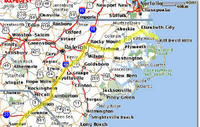
A section of Route 12, just north of the village of Rodanthe, North Carolina, increasingly has become flood-prone over the past decade due in part to rapid beach erosion in the area; wind-driven waves from a slow-moving mid-November storm buckled and undermined approximately 800 ft of pavement, flattened 900 ft of 15-ft to 20-ft-high sand dunes, and damaged hundreds of sandbags placed by NCDOT following a 2007 storm event; the North Carolina Department of Transportation has decided to relocate 1,800-ft-long stretch of the highway
-
The long view
The Surprising Reasons Floods and Other Disasters Are Deadlier at Night
It’s not just that it’s dark and people are asleep. Urban sprawl, confirmation bias, and other factors can play a role.
Why Flash Flood Warnings Will Continue to Go Unheeded
Experts say local education and community support are key to conveying risk.