-
Mobile biometric device expedites identity matching
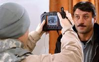
The Stockton (California) Police Department (SPD) has been quietly testing a state-of-the-art Mobile Biometric Device (MBD) technology for the past four years. Designed quickly to scan fingerprints, irises, and other biological information while officers and evidence technicians are on the field, MBDs can communicate with remote fingerprint databases and confirm matches in as little as three minutes.
-
-
San Francisco to add local groundwater to reservoir supply
The San Francisco Public Utilities Commission has begun digging in the area around Golden Gate Park with the intention of adding local underground water flows to the traditionally sourced water from the Hetch Hetchy Reservoir in Yosemite. The change is expected to take place over the next two years and will replace between 10 to 15 percent of the water supply. Despite the fact that the water is less pure, city officials expect that difference will be negligible.
-
-
Global warming skeptics unmoved by extreme weather
What will it take to convince skeptics of global warming that the phenomenon is real? Surely, many scientists believe, enough droughts, floods, and heat waves will begin to change minds. A new study throws cold water on that theory. Winter 2012 was the fourth warmest winter in the United States dating back to at least 1895. Researchers found, however, that when it came to attributing the abnormally warm weather to global warming, respondents largely held fast to their existing beliefs and were not influenced by actual temperatures. This study and past research shows that political party identification plays a significant role in determining global warming beliefs. People who identify as Republican tend to doubt the existence of global warming, while Democrats generally believe in it.
-
-
China’s second “great wall” is not so great
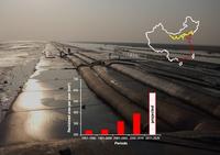
China’s coastal regions are only 13 percent of the country’s land area, but contribute 60 percent of its gross domestic product. With that come layers of incentives to turn lush wetlands into engines of development and industry. A new study finds that China’s second great wall, a vast seawall covering more than half of the country’s mainland coastline, is a foundation for financial gain - and also a dyke holding a swelling rush of ecological woes.
-
-
New, updated resource on STEM education, workforce
It just became a lot easier for educators, students, parents, policymakers and business leaders to learn more about national trends in education and jobs in science, technology, engineering, and mathematics (STEM). The National Science Board (NSB) last month released an interactive, online resource featuring new and updated data and graphics about STEM education and workforce in the United States and providing facts on topics such as student proficiency, college degrees in STEM fields, and jobs in science-related occupations.
-
-
Los Alamos National Lab: Deploying 100 supercomputers over 60 years in support of national security

From the 1952 MANIAC to Bonanza deployed just this month, Los Alamos National Laboratory has deployed 100 supercomputers in the last sixty years — a showcase of high-performance computing history. The Los Alamos computers deployed along the way include the MANIAC II, which started its nearly 20-year service life with over 5,000 vacuum tubes, all of which were replaced over time with circuit boards. Other deployed systems include Stretch, a technological stretch built in collaboration between Los Alamos and IBM, Serial Number 1 of the iconic Cray-1, and a Thinking Machines CM-5, with its lightning bolt footprint and fat-tree interconnect. By 2008 there came Roadrunner, the world’s first petaflop supercomputer.
-
-
New technology increases awareness of landslide risks
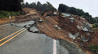
Engineers have created a new way to use lidar technology to identify and classify landslides on a landscape scale, which may revolutionize the understanding of landslides in the United States and reveal them to be far more common and hazardous than often understood. The new, non-subjective technology can analyze and classify the landslide risk in an area of fifty or more square miles in about thirty minutes — a task that previously might have taken an expert several weeks to months. It can also identify risks common to a broad area rather than just an individual site.
-
-
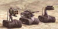
Transforming planes into flying aircraft carriers
Military air operations typically rely on large, manned, robust aircraft, but such missions put these expensive assets — and their pilots — at risk. While small unmanned aircraft systems (UAS) can reduce or eliminate such risks, they lack the speed, range, and endurance of larger aircraft. These complementary traits suggest potential benefits in a blended approach — one in which larger aircraft would carry, launch, and recover multiple small UAS. A flying carrier would allow the United States to use of drones in areas where the United States has no access to nearby airfields, but recovering a drone in mid-air remains a daunting technical challenge.
-
-
New acoustic sensor for chemical, biological detection
Testing for ovarian cancer or the presence of a particular chemical could be almost as simple as distinguishing an F sharp from a B flat, thanks to a new microscopic acoustic device that has been dramatically improved by scientists at the Argonne National Laboratory. The device, known as a surface acoustic wave (SAW) sensor, detects frequency changes in waves that propagate through its crystalline structure. This makes it ideal for detecting the presence of chemicals or biomarkers present in a liquid or gas.
-
-
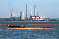
Water sector ready for investment, technological innovation
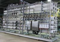
Investors looking for promising growth markets would do well to consider their water bill. Water’s artificially low price in most of the United States is one factor holding back innovative new water technologies, according to the report – but the time is right for change. Across the West, drought has left wide swaths of agricultural land brown, with massive wildfires raging through tinder-dry forests, residential wells tapped out and unemployed farm workers crowding food pantries. The drought is projected to cost the agricultural sector about $2.2 billion in 2014. The social and ecological damage is also profound. Technological innovation in the water sector could bring a raft of benefits ranging from the conservation of scarce water supplies to the expansion of water supplies through technologies that recycle or desalinate, for example.
-
-
Wi-Fi signals enable through-wall detection
Engineers prove the concept that local Wi-Fi signals can be used to monitor moving objects and bodies that are otherwise visually obscured. Although fundamentally similar to traditional radar systems, their novel approach is entirely passive — utilizing the wireless signals that already swamp our urban airways. This technology has a wide range of applications from healthcare monitoring, security and emergency disaster relief, to finding earthquake survivors in fallen buildings.
-
-
Porous molecules bind greenhouse gases
While carbon dioxide presents the biggest greenhouse problem, several other compounds are hundreds or thousands of times more potent in their greenhouse effect per unit of mass. These compounds include Freons, used as common refrigerants, and fluorocarbons, highly stable organic compounds in which one or more hydrogen atoms have been replaced with fluorine. Chemistry researchers have developed a molecule that assembles spontaneously into a lightweight structure with microscopic pores capable of binding large quantities of several potent greenhouse gases.
-
-
New app turns smartphones into sensors for an earthquake early-warning system
The MyShake app, still in test mode, uses smartphone accelerometers and locators to augment the data on incoming quakes issued by the 400 seismometers which are part of California’s ShakeAlert program.Registered phones act as additional earthquake sensors, as the app runs an algorithm which detects when the phone is still or shaking. Should several registered phones in the same area begin to shake at the same time, an earthquake alert is issued.
-
-
Autonomous weapons which select, destroy targets without human intervention proliferate
More scientists are expressing concern over autonomous weapons which are able to select and destroy targets without human control or oversight. Armed drones can be operated by remote pilots, but weapons of the future will rely more on artificial intelligence to decide what to target and whom to kill.
-
-
Gas can be a “bridge fuel” to a low-carbon future
Major new suggests that gas could play an important role as a “bridging fuel” to a low-carbon economy, but warns that it will not be long before gas becomes part of the problem rather than the solution. The research combines the latest energy system modelling techniques with analysis of U.K. gas security to assess future demand.
-
The long view
New Technology is Keeping the Skies Safe
DHS S&T Baggage, Cargo, and People Screening (BCP) Program develops state-of-the-art screening solutions to help secure airspace, communities, and borders
Factories First: Winning the Drone War Before It Starts
Wars are won by factories before they are won on the battlefield,Martin C. Feldmann writes, noting that the United States lacks the manufacturing depth for the coming drone age. Rectifying this situation “will take far more than procurement tweaks,” Feldmann writes. “It demands a national-level, wartime-scale industrial mobilization.”
How Artificial General Intelligence Could Affect the Rise and Fall of Nations
Visions for potential AGI futures: A new report from RAND aims to stimulate thinking among policymakers about possible impacts of the development of artificial general intelligence (AGI) on geopolitics and the world order.
Smaller Nuclear Reactors Spark Renewed Interest in a Once-Shunned Energy Source
In the past two years, half the states have taken action to promote nuclear power, from creating nuclear task forces to integrating nuclear into long-term energy plans.
Keeping the Lights on with Nuclear Waste: Radiochemistry Transforms Nuclear Waste into Strategic Materials
How UNLV radiochemistry is pioneering the future of energy in the Southwest by salvaging strategic materials from nuclear dumps –and making it safe.
Model Predicts Long-Term Effects of Nuclear Waste on Underground Disposal Systems
The simulations matched results from an underground lab experiment in Switzerland, suggesting modeling could be used to validate the safety of nuclear disposal sites.