-
Cities seek new ways to cope with sea level rise – and look to the Dutch for advice
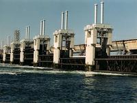
Scientists predict a “tenfold increase” in the frequency of hurricanes and other storms, as well as sea-level rise of eleven to twenty-four inches within a little more than three decades – and planners and managers in U.S. coastal cities are looking at new ways to prepare their cities’ infrastructure for these challenges. In New York and New Orleans, city planners are studying the experience of the Dutch, who have gained a lot of experience – and fame — for their water control methods.
-
-
Rural towns lose to urban centers in competition for coastal protection funding
Infrastructure protection planners say there are only three ways coastal communities can defend themselves against rising sea levels: defend the shoreline with both natural and man-made barriers; raise key infrastructure such as buildings and roads; or retreat from the shoreline. Each of these options costs a fortune to follow. Smaller, more rural coastal communities in many states are finding that they are having a hard time competing with more powerful interests in coastal urban cities over funding for protection against sea-level rise.
-
-
Florida Keys preparing for rising sea levels
The Florida Keys rank third among East Coast communities at risk of “population displacement” due to higher seas which will flood nearby land. Scientists say that if sea levels continue to rise at the current rate, high waters which drowned the Keys during 2005’s Hurricane Wilma could become a normal part of living in Monroe County by 2060. Officials in Monroe County, Florida are putting together a GreenKeys Sustainability Action Plan which will help residents of the Florida Keys maintain a sustainable lifestyle while under threat of sea-level rise due to climate change.
-
-
New Orleans creates economic value out of environmental vulnerability
Following the devastation of Hurricane Katrina in 2005, New Orleans and the state of Louisiana have become so adept at dealing with disaster reconstruction, that their new-found skills are now seen as an economic asset to be shared, for profit, with other states and localities. The area’s new environmental awareness is also a source of economic growth, as analysts now consider “emerging environmental” as one of six key industries in the city and state to focus on development, along with coastal restoration and water management, disaster mitigation and management, hazardous waste disposal, advanced bio fuels and waste water treatment.
-
-
Better solutions for recycle fracking water
Scientists have performed a detailed analysis of water produced by hydraulic fracturing (aka fracking) of three gas reservoirs and suggested environmentally friendly remedies are needed to treat and reuse it. More advanced recycling rather than disposal of “produced” water pumped back out of wells could calm fears of accidental spillage and save millions of gallons of fresh water a year.
-
-
Existing power plants will emit 300 billion more tons of carbon dioxide during use
Existing power plants around the world will pump out more than 300 billion tons of carbon dioxide over their expected lifetimes, significantly adding to atmospheric levels of the climate-warming gas, according to a new study. The study is the first to quantify how quickly these “committed” emissions are growing — by about 4 percent per year — as more fossil fuel-burning power plants are built. Assuming these stations will operate for forty years, the power plants constructed globally in 2012 alone will produce about nineteen billion tons of CO2 during their existence, the researchers project.
-
-
Southwest may face “megadrought” within century: Study
Due to global warming, scientists say, the chances of the southwestern United States experiencing a decade-long drought is at least 50 percent, and the chances of a “megadrought” — one that lasts up to thirty-five years — ranges from 20 to 50 percent over the next century. While the 1930s Dust Bowl in the Midwest lasted four to eight years, depending upon location, a megadrought can last more than three decades, which could lead to mass population migration on a scale never before seen in this country.
-
-
Antarctica to become major contributor to sea level rise faster than previously thought
While Antarctica currently contributes less than 10 percent to global sea level rise and is a minor contributor compared to the thermal expansion of the warming oceans and melting mountain glaciers, it is Greenland and especially the Antarctic ice sheets with their huge volume of ice that are expected to be the major contributors to future long-term sea level rise.
-
-
Solar super-storms “inevitable”: Scientists
Solar storms are caused by violent eruptions on the surface of the Sun and are accompanied by coronal mass ejections (CME). The largest ever solar super-storm on record occurred in 1859 and is known as the Carrington Event: This massive CME released about 1,022 kJ of energy — the equivalent to ten billion Hiroshima bombs exploding at the same time — and hurled around a trillion kilograms of charged particles towards the Earth at speeds of up to 3,000 km/s. These types of events are not just a threat, but inevitable. NASA scientists have predicted that the Earth is in the path of a Carrington-level event every 150 years on average — which means that we are currently five years overdue — and that the likelihood of one occurring in the next decade is as high as 12 percent.
-
-
Tornado strength, frequency linked to climate change
New research shows that climate change may be playing a key role in the strength and frequency of tornadoes hitting the United States. Though tornadoes are forming fewer days per year, they are forming at a greater density and strength than ever before. “We may be less threatened by tornadoes on a day-to-day basis, but when they do come, they come like there’s no tomorrow,” one of the researchers said.
-
-
Key U.S. coastal areas bracing for greater sea level rise challenges
While climate change-related sea level rise is predicted to impact much of the country — whether directly or indirectly — over the next several decades, certain parts of the nation’s coasts are expecting to deal with more unique and intensive challenges.
-
-
N.C. science panel begins updating sea level rise report
North Carolina officials announced last week that the state-appointed science panel supported by the Coastal Resources Commission(CRC) has begun updating a controversial 2010 sea-level rise report. The CRC oversees development in North Carolina’s twenty coastal counties. In May, the CRC votedto narrow the scope of the pending report to reflect the effects of sea-level rise for the next thirty-years, as opposed to the original timeframe of 100 years in the 2010 report. “I think the concept of doing it for 30 years will add credibility to the study,” Frank Gorham, the CRC’s chairman, said last Thursday. “People can think in 30-year timeframes.”
-
-
National vision needed to achieve comprehensive risk reduction along Atlantic, Gulf coasts
A national vision for coastal risk management that includes a long-term view, regional solutions, and recognition of the full array of economic, social, environmental, and safety benefits that come from risk management is needed to reduce the impacts of natural disasters along the Atlantic and Gulf coasts of the United States, says a new report. To support this vision, a national coastal risk assessment is needed to identify coastal areas that face the greatest threats and are high priorities for risk-reduction efforts.
-
-
Using natural, engineering solutions to help U.K. address extreme weather events
The United Kingdom is seeing increased seasonal flood damage not only from coastal and river surges, but from rising groundwater as well. The scale and unpredictability of these events in recent years, while devastating, can also serve as a helpful mirror of future climate change and its predicted effects in the longer term. Experts say that natural solutions, such as reforestation, to improve flood defenses and attempts to keep water in place may provide both short and long term solutions.
-
-
Drought-driven use of underground water threatens water supply of western U.S.
Scientists find that more than 75 percent of the water loss in the drought-stricken Colorado River Basin since late 2004 came from underground resources. The Colorado River is the only major river in the southwest part of the United States. Its basin supplies water to about forty million people in seven states, as well as irrigating roughly four million acres of farmland. Monthly measurements in the change in water mass from December 2004 to November 2013 revealed the basin lost nearly 53 million acre feet (65 cubic kilometers) of freshwater, almost double the volume of the nation’s largest reservoir, Nevada’s Lake Mead. More than three-quarters of the total — about 41 million acre feet (50 cubic kilometers) — was from groundwater. The extent of groundwater loss may pose a greater threat to the water supply of the western United States than previously thought.
-
- All
- Regional
- Water
- Biometrics
- Borders/Immig
- Business
- Cybersecurity
- Detection
- Disasters
- Government
- Infrastructure
- International
- Public health
- Public Safety
- Communication interoperabillity
- Emergency services
- Emergency medical services
- Fire
- First response
- IEDs
- Law Enforcement
- Law Enforcement Technology
- Military technology
- Nonlethal weapons
- Nuclear weapons
- Personal protection equipment
- Police
- Notification /alert systems
- Situational awareness
- Weapons systems
- Sci-Tech
- Sector Reports
- Surveillance
- Transportation
Advertising & Marketing: advertise@newswirepubs.com
Editorial: editor@newswirepubs.com
General: info@newswirepubs.com
2010-2011 © News Wire Publications, LLC News Wire Publications, LLC
220 Old Country Road | Suite 200 | Mineola | New York | 11501
Permissions and Policies
Editorial: editor@newswirepubs.com
General: info@newswirepubs.com
2010-2011 © News Wire Publications, LLC News Wire Publications, LLC
220 Old Country Road | Suite 200 | Mineola | New York | 11501
Permissions and Policies