-
Oregon declares state of emergency to repair damaged ports
The 11 March tsunami born of Japan’s 8.9 magnitude quake battered U.S. coasts and ports from Hawaii and the Pacific Northwest to southern California; the governor’s office in Hawaii expects damages to run about $10 million with estimates heading toward $50 million in California; one county in Oregon is reporting $25 million worth of destruction in one of three damaged ports
-
-
Past "hyperthermals" offer clues about anticipated climate changes
Bursts of intense global warming that have lasted tens of thousands of years have taken place more frequently throughout history than previously believed; most of the events raised average global temperatures between 2° and 3° Celsius (3.6 and 5.4° F), an amount comparable to current conservative estimates of how much temperatures are expected to rise in coming decades as a consequence of anthropogenic global warming; most hyperthermals lasted about 40,000 years before temperatures returned to normal
-
-
Shock absorbers making buildings earthquake-proof
An upstate New York manufacturer has developed dampers, or shock absorbers, which increase the earthquake resistance of a building by threefold; the patented dampers are based on technology first developed by the military to protect U.S. missile silos against Russian attacks during the cold war
-
-
Minnesota braces for spring floods
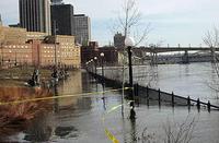
As dense snow packs in Minnesota begin to melt, officials are preparing for what may be their worst spring flooding yet; with record snow falls and heavy rains expected, weather officials are forecasting that floods are on their way; last September’s heavy rains saturated the soil with water which will exacerbate spring floods this year; officials are preparing the state for floods and St. Paul city officials have sent letters to all residents warning that they should find alternative places to stay and keep their vehicles in safe areas if they are forced to evacuate as water levels rise
-
-
The problems with major disasters
There are three problems with major disasters: small miscalculations of probabilities can have large effects on outcomes when dealing with large events; our reward structures do not encourage spending the time or the money to deal with low-probability disasters; the very complexity of modern life — including our transportation and communication systems, our economy and our social interactions — is directly implicated in the severity of catastrophes; in more complex systems, even small changes or perturbations can have disproportionate and unpredictable effects
-
-
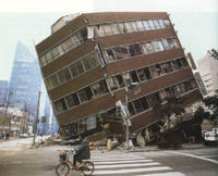
Japan facing a nuclear catastrophe
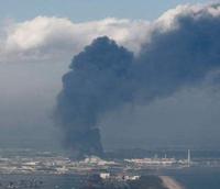
Initial estimates say that the Magnitude 9.0 earthquake and tsunami killed about 10,000 people and made hundreds of thousands homeless; Japan is facing another threat: radioactive contamination from four damaged nuclear power plants; the tremor damaged the cooling systems in the reactors, forcing the companies operating the plants to flood the reactors with corrosive sea water and boric acid; one containment vessel was destroyed in an explosion, and in order to prevent more explosion, radioactive-contaminated hydrogen had to be released, increasing the radioactive levels to unsafe levels; more than 200,000 people living in the vicinity of the reactors were evacuated; the government has began distributing iodine pills to citizens (the pills are used to protect the thyroid gland from the effects of radiation); the difficulties at the nuclear power plants mean that rotating power outages will be imposed across Japan as of Monday
-
-
Sensors detecting nuclear tests detect tsunamis, too
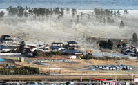
The Comprehensive Nuclear test-Ban Treaty (CTBT) is supported by arrays of sensors at sixty sites across the world that listen for the low boom of atmospheric blasts. They are tuned to infrasound — frequencies under 20 hertz (cycles per second), the lowest humans can hear; these sensors are meant to pick up illicit nuclear tests, but they can also pick up tsunami-producing tremors — and provide timely warning to those likely to be affected
-
-
Anchorage unprepared for next big quake
Geologists warn that Alaska’s next big earthquake could be even larger than the Good Friday earthquake of 1964; the massive 9.2 magnitude earthquake is the second largest quake in recorded history and resulted in massive ground failures, tsunamis, and landslides; officials are worried about the Port of Anchorage which lies along an area that is highly susceptible to ground failure; engineers warn that with more than 50 percent of its foundation corroded the port cannot survive another massive quake; large portions of Anchorage are also vulnerable as building codes have not been strictly enforced; the city is built upon a unique soil that is prone to liquefaction in large earthquakes
-
-
New Orleans debates hurricane protection plans
The Army Corps of Engineers is currently deciding how best to implement its $2.9 billion Mississippi River-Gulf Outlet (MR-GO) restoration plan in New Orleans; the plan is part of several projects designed to protect the Louisiana coast line from hurricane storm surges; residents are clashing over the plan and the public hearing period for the plan has been extended; state legislators are currently debating with the corps, as the $2.9 billion project funds do not include the costs for land acquisition, design, and operation and maintenance; the project is expected to take ten years to complete and construction could begin as early as 2012
-
-
Building smarter infrastructure out of the rubble
As Australia and New Zealand look to rebuild following the natural disasters in Christchurch and Queensland, experts have found a silver lining: the opportunity to rebuild with smarter infrastructure; architects, risk managers, and other experts say that cities devastated by natural disasters should amend building codes and implement smarter technology in buildings as they are resurrected from the rubble
-
-
Earth's sixth mass extinction may have already arrived
With the steep decline in populations of many animal species, from frogs and fish to tigers, some scientists have warned that Earth is on the brink of a mass extinction like those that occurred only five times before during the past 540 million years; each of these Big Five saw three-quarters or more of all animal species go extinct
-
-
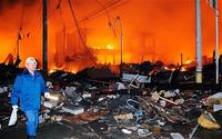
New Zealand quake could take ten years and $15 billion to clean up
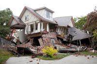
David Carter, New Zealand’s acting economic development minister, estimates that it could take ten years to rebuild Christchurch after a 6.3 magnitude earthquake rocked the town last month; the cost of rebuilding is estimated at $15 billion and climbing; nearly a third of the buildings in its business district have been declared unsafe; New Zealand prime minister John Key ruled out an earthquake tax for fear it would hurt the economy, which has been hit hard by the recession; New Zealand is actively soliciting international aid to help with its recovery; Christchurch has a population of roughly 377,000 and makes up about 15 percent of the nation’s economy
-
-
Scientists warn solar storms could be "global Hurricane Katrina"
Scientists warn that massive solar storms could be the equivalent of a “global Hurricane Katrina”; these storms could cause $2 trillion in damages to communications equipment, power grids, and GPS systems; experts are particularly concerned about solar flares due to the increased reliance on electrical communication systems and the approach of a period of intense solar activity; solar flares can cause power surges that are powerful enough to knock out electrical grids and induce electric currents in oil pipelines; in 2013 the sun will enter a peak in its eleven year solar cycle that is expected to generate a significant number of powerful solar flares; last month a solar flare generated magnetic storms and power surges that disrupted communications and grounded flights
-
-
Engineers use Xbox Kinect to find earthquake survivors
A team of engineers at the University of Warwick in the United Kingdom has been working to develop a robot capable of entering unstable buildings and searching for survivors, such as the 200 purportedly missing after the 6.3 magnitude earthquake in Christchurch, New Zealand; until now, technology has relied on expensive laser-based equipment, but Warwick’s team has reconfigured Microsoft’s Xbox Kinect to identify places in which survivors may be
-
-
Ancient catastrophic drought a warning about current warming trends
Extreme megadrought in Afro-Asian region likely had consequences for Paleolithic cultures; the records show that one of the most widespread and intense droughts of the last 50,000 years or more struck Africa and Southern Asia 17,000 to 16,000 years ago; the “H1 megadrought” was one of the most severe climate trials ever faced by anatomically modern humans; Africa’s Lake Victoria, now the world’s largest tropical lake, dried out, as did Lake Tana in Ethiopia, and Lake Van in Turkey; the Nile, Congo, and other major rivers shriveled
-
The long view
The Surprising Reasons Floods and Other Disasters Are Deadlier at Night
It’s not just that it’s dark and people are asleep. Urban sprawl, confirmation bias, and other factors can play a role.
Why Flash Flood Warnings Will Continue to Go Unheeded
Experts say local education and community support are key to conveying risk.