-
Electromagnetic fields could be used in tsunami early warning
Could electromagnetic (EM) fields be used in tsunami early warning? New research shows that important focal parameters of tsunamigenic earthquakes — particularly fault dip direction — can be extracted from tsunami-borne EM fields.
-
-
State budgets $10 million for earthquake early warning
Governor Jerry Brown has signed a 2016-17 state budget that provides $10 million to help launch a statewide earthquake early-warning system. Although California passed a mandate in 2013 to create a statewide earthquake warning system, this is the first money appropriated by the state to make it a reality. The federal government has already provided $13.2 million to improve and test a prototype West Coast early-warning system, but this is much less than the $38 million in buildout costs and $16 million per year in operating costs needed to establish a fully functioning system serving California, Oregon, and Washington.
-
-
France unveils app to alert people to terror attacks
Euro 2016 soccer tournament begins on Friday, and as part of the massive security operation undertaken to secure the ten millions spectators who will be watching the games from 10 June to 10 July, the French government has created a smartphone app designed to send warnings directly to people’s phones in the event of a bombing, shooting, or other disaster.
-
-
Improving hurricane intensity predictions through early use of “hurricane hunter” data
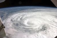
Data collected via airplane when a hurricane is developing can improve hurricane intensity predictions by up to 15 percent, according to researchers who have been working with the National Oceanic and Atmospheric Administration and the National Hurricane Center to put the new technique into practice.
-
-
A warning system for tsunamis
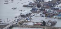
Right now, tsunami warning systems rely on region-specific scenarios based on previous patterns in that area. This is because scientists use sensors in the ocean, which can detect abnormal movements but cannot make accurate projections of how much water will hit a coast and how hard. But “most likely” is not a sure thing. Seismologists have created a new algorithm that could one day help give coastal cities early warning of incoming tsunamis.
-
-
Japanese-language MyShake app crowdsources earthquake-shaking information
UC Berkeley scientists have released a Japanese version of an Android app that crowdsources ground-shaking information from smartphones to detect quakes and eventually warn users of impending jolts from nearby quakes. The app, called MyShake, became publicly available on Sunday. Since it was first released in English on 12 February 2016, more than 170,000 people have downloaded the app from around the world, and on any given day 11,000 phones provide data to the system.
-
-
Seismic networks can serve as the backbone for 21st century firefighting
The same twenty-first century communications network used for real-time seismic monitoring in Nevada and parts of California can provide high-quality images to help first responders catch fires before they grow costly and dangerous. Experts say that seismic networks in place to provide earthquake early warning, if designed to sustain multi-hazard monitoring, can provide a robust data backbone for fire cameras that pan, tilt and zoom as they monitor wildfires and other extreme weather events like remote floods.
-
-
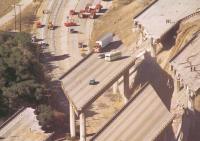
Japan’s successful earthquake early warning system offers lessons to U.S. high-speed rail
As California and other states move forward with high-speed rail plans, some have questioned the system’s ability to withstand earthquakes. This is especially critical in California, an active quake zone. A recent research report says that valuable lessons are easily adapted from Japan’s successes with its early earthquake warning (EEW) systems. This was most recently demonstrated during the series of violent quakes that shook Japan in mid-April, 2016.
-
-
Worries in southern California: San Andreas fault “locked, loaded, and ready to roll”
Top seismologists have warned residents of southern California that the region is overdue for a major earthquake. The San Andreas fault is “locked, loaded and ready to go,” said Thomas Jordan, director of the Southern California Earthquake Center. Meanwhile, in the Pacific Northwest, Mount St Helens is waking up, with as many as 130 small earthquakes detected beneath the mountain in recent weeks.
-
-
Citizen seismologists enhance the impacts of earthquake studies
From matchbook-sized sensors plugged into a desktop computer to location-tagged tweets, the earthquake data provided by “citizen seismologists” have grown in size and quality since 2000, according to the field’s researchers.
-
-
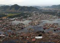
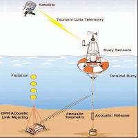
All of Indonesia’s Tsunami early warning buoys were inoperable before 7.8 magnitude tremor
At the time of the 7.8-magnitude earthquake which struck off the Indonesian coast on Wednesday night, all of Indonesia’s tsunami early warning buoys were inoperable. The shallow tremor 600 km off Sumatra island did not generate a tsunami, but the incident has raised questions about the effectiveness of the early warning system, which was deployed in the wake of the devastating 2004 tsunami.
-
-
GPS allows for better, faster tsunami warnings
Existing GPS instruments at monitoring stations worldwide could be used to increase the speed and accuracy of tsunami warnings, according to a new study. Real-time Global Positioning System (GPS) measurements can be used to show how major earthquakes displace the ocean floor, cutting tsunami warning times by nearly twenty minutes and potentially reducing harm to coastal communities, according to researchers.
-
-
Smartphones app creates worldwide seismic network

UC Berkeley scientists last week released a free Android app that taps a smartphone’s ability to record ground shaking from an earthquake, with the goal of creating a worldwide seismic detection network that could eventually warn users of impending jolts from nearby quakes. The app, called MyShake, is available from the Google Play Store and runs in the background with little power, so that a phone’s onboard accelerometers can record local shaking any time of the day or night.
-
-
Discovery of “hidden earthquake” challenges tsunami early-warning systems
Seismologists studying the 2011 Chile earthquake have discovered a previously undetected earthquake which took place seconds after the initial rupture. This newly discovered phenomena which they have called a “closely spaced doublet” presents a challenge to earthquake and tsunami early warning systems as it increases the risk of larger-than-expected tsunamis in the aftermath of a typical subduction earthquake.
-
- All
- Regional
- Water
- Biometrics
- Borders/Immig
- Business
- Cybersecurity
- Detection
- Disasters
- Government
- Infrastructure
- International
- Public health
- Public Safety
- Communication interoperabillity
- Emergency services
- Emergency medical services
- Fire
- First response
- IEDs
- Law Enforcement
- Law Enforcement Technology
- Military technology
- Nonlethal weapons
- Nuclear weapons
- Personal protection equipment
- Police
- Notification /alert systems
- Situational awareness
- Weapons systems
- Sci-Tech
- Sector Reports
- Surveillance
- Transportation
Advertising & Marketing: advertise@newswirepubs.com
Editorial: editor@newswirepubs.com
General: info@newswirepubs.com
2010-2011 © News Wire Publications, LLC News Wire Publications, LLC
220 Old Country Road | Suite 200 | Mineola | New York | 11501
Permissions and Policies
Editorial: editor@newswirepubs.com
General: info@newswirepubs.com
2010-2011 © News Wire Publications, LLC News Wire Publications, LLC
220 Old Country Road | Suite 200 | Mineola | New York | 11501
Permissions and Policies