-
Future UAVs will emulate birds
Engineers at UC San Diego are mimicking the movement of bird wings to help improve the maneuverability of unmanned aerial vehicles (UAVs); this is important, because UAVs are quickly becoming popular tools for the armed forces, and there are also a myriad of civilian applications which are rapidly developing, such as border control, wildfire monitoring, search and rescue, and traffic observation
-
-
DARPA crowd-source next-gen UAV design
DARPA has announced its UAVForge competition for the design of a user-intuitive, backpack-portable UAV which is also quiet, can stay aloft for at least three hours, and can fly in harsh condition; in addition to the $100,000 prize, the winning team will have the opportunity to showcase its design in an overseas military exercise
-
-
Arlington, Texas hopes to keep aerial drone
The police department of Arlington, Texas is examining ways to fund an unmanned surveillance drone; the drone was originally purchased with grant money from DHS to assist local police officers with security during Super Bowl XLV held at Cowboys Stadium in Arlington last February; the drone is still technically owned its unidentified manufacturer and the City Council is debating how to pay for the drone’s operation and maintenance
-
-
Quadrotor micro UAVs go mainstream
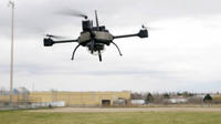
A Canadian company develops small quadrotor micro UAVs for use by law enforcement, first responders, and the military; the company’s Scout has a range of three kilometers and maximum speed of 50 kilometers per hour; it can fly through wind gusts of up to 80 km/h, and can cope with harsh weather conditions; the Scout is light — it weighs about one kilogram — and can be carried disassembled in a case and be assembled quickly by snapping its rotors into the main body
-
-
Goodyear changes blimps to Zeppelins

There are few things more familiar to Americans than the Goodyear Blimp; no major sporting event would be complete without one of these blimps hovering overhead; during its long operational history, Goodyear has built and operated more than 300 airships; currently, the company has a fleet of three blimps, based in Ohio, Florida, and California; these blimps are reaching the end of their operational life, and Goodyear has signed an agreement with German company ZLT Zeppelin Luftschifftechnik to supply Goodyear with airships well into the next decade; the new Goodyear-Zeppelin airships will be slightly larger than the airships in Goodyear’s current fleet, fly faster, carry more passengers, and include state-of-the art avionics and flight control systems
-
-
Phantom Ray completes maiden flight
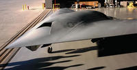
Phantom Ray, Boeing’s fighter-sized unmanned airborne system (UAS), took to the early morning skies on 27 April at Edwards Air Force Base in California for its maiden flight; Phantom Ray is one of several programs in Boeing’s Phantom Works division, including Phantom Eye, which is part of a rapid prototyping initiative to design, develop, and build advanced aircraft and then demonstrate their capabilities
-
-
Texas lawmakers fight for more drones
Texas lawmakers are pushing federal officials to deploy more unmanned aerial vehicles (UAVs) along the state’s southern border with Mexico; currently one Predator drone patrols the skies above Texas’ border and the Gulf Coast, while three Predators operate out of Arizona and one in North Dakota; Representative Henry Cuellar (D-Texas) and two other congressman from Texas recently met with state and federal officials to lobby for the additional deployment of drones
-
-
Student aero-design competition to be held next week
The Aero Design competition, to be held at the end of the month, is intended to provide undergraduate and graduate engineering students with a real-life engineering challenge; the organizers say the competition has been designed to provide exposure to the kinds of situations that engineers face in their real-life work environment; students will find themselves performing trade studies and making compromises to arrive at a design solution that will optimally meet the mission requirements while still conforming to the configuration limitations
-
-
Experts call for rules of the road for drone use in the Americas
More and more Latin and Central American countries are using UAVs for domestic policing missions; these drones are employed as a high-tech answer by government to problems such as drug trafficking, gang violence, deforestation, and other illegal activities; experts say that Latin American countries should collaborate in developing a code of conduct that will prevent the arming of drones and assuage civilian concerns
-
-
U.S. Air Force wants mind reading aerial drones
The U.S. Air Force is currently working with several firms to develop aerial drones that have the ability to think and anticipate a controller’s actions before it occurs; the Air Force began exploring this capability in order to avoid collisions during takeoff and landings at busy airport terminals where both manned and unmanned planes launch; to address this problem, the Air Force awarded contracts to several firms to develop predictive software that can anticipate a pilot’s reaction if a drone is flying too closely
-
-
Bird-like visual sense to help UAVs navigate in urban environments
The U.S. Office of Naval Research (ONR) has awarded researchers $4.5 million to develop a bird-sized, self-flying plane that could navigate through both forests and urban environments; the plane would be about the size of a crow, and, like a bird, would use vision to navigate, but it would use orientable propellers and not flap its wings; the drone will rely, in part, on a technology that emulates the visual system of animals called Convolutional Networks, which mimics the neural network in the mammalian visual cortex and can be trained quickly to interpret the world around it
-
-
U.S. Army surveillance blimp destroyed in accident
The U.S. military wants to place powerful sensors on blimps, and have these blimps loiter the sky above the battlefield; the sensors, produced by Raytheon, will enable battlefield commanders to increase their wide-area protection against land-attack cruise missiles; last September, two blimps moored next to each other in the Elizabeth City, North Carolina manufacturing facility, collided after one of them almost got loose; the cost to the Army: $168 million
-
-
U.S. to reconsider use of drones in Pakistan
In the last twenty-four months, U.S. drones have killed some 1,000 militants — but also about 600 civilians; in an effort to shore up fraying relationship with Pakistan, the U.S. ambassador to Pakistan said the United States would examine the continued use of drones in the war against the militants; Pakistani prime minister Asif Ali Zardari said the drone war has destabilized Pakistan and made political and economic reforms more difficult to accomplish
-
-
New radar optimized for homeland security
A new radar is designed to provide an affordable, modular solution for border protection and coverage of wide areas, offering good detection capability of ground targets and aerial targets, specifically homeland security-relevant objects flying slow at very low level
-
-
South Carolina police departments unveil aerial drones
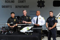
Two local police departments in South Carolina recently unveiled the latest additions to their arsenal of law enforcement tools — remote controlled mini helicopters; these small helicopters are equipped with cameras and will allow police officers to conduct aerial surveillance, search for missing persons, or monitor dangerous situations from a distance; the remote controlled vehicles cost about twenty-five cents in electricity to charge the battery and less than $4,000 to purchase, far cheaper than full size helicopters; the drones’ battery can last for up to forty minutes, and helps it run silently making it ideal for discrete surveillance
Two local police departments in South Carolina recently unveiled the latest additions to their arsenal of law enforcement tools – remote controlled mini helicopters. -
- All
- Regional
- Water
- Biometrics
- Borders/Immig
- Business
- Cybersecurity
- Detection
- Disasters
- Government
- Infrastructure
- International
- Public health
- Public Safety
- Communication interoperabillity
- Emergency services
- Emergency medical services
- Fire
- First response
- IEDs
- Law Enforcement
- Law Enforcement Technology
- Military technology
- Nonlethal weapons
- Nuclear weapons
- Personal protection equipment
- Police
- Notification /alert systems
- Situational awareness
- Weapons systems
- Sci-Tech
- Sector Reports
- Surveillance
- Transportation
Advertising & Marketing: advertise@newswirepubs.com
Editorial: editor@newswirepubs.com
General: info@newswirepubs.com
2010-2011 © News Wire Publications, LLC News Wire Publications, LLC
220 Old Country Road | Suite 200 | Mineola | New York | 11501
Permissions and Policies
Editorial: editor@newswirepubs.com
General: info@newswirepubs.com
2010-2011 © News Wire Publications, LLC News Wire Publications, LLC
220 Old Country Road | Suite 200 | Mineola | New York | 11501
Permissions and Policies