SurveillanceSmaller lidars could be mounted on UAVs for underwater scans
Bathymetric lidars — devices which employ powerful lasers to scan beneath the water’s surface — are used today primarily to map coastal waters. At nearly 600 pounds, the systems are large and heavy, and they require costly, piloted aircraft to carry them. Georgia Tech Research Institute (GTRI) researchers have designed a new approach that could lead to bathymetric lidars that are much smaller and more efficient than the current full-size systems. The new technology would let modest-sized unmanned aerial vehicles (UAVs) carry bathymetric lidars, lowering costs substantially. These advanced capabilities could support a range of military uses such as anti-mine and anti-submarine intelligence and nautical charting, as well as civilian mapping tasks. In addition, the new lidar could probe forested areas to detect objects under thick canopies.
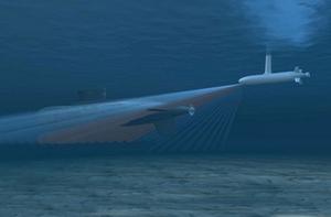
With attached lidar, this drone can map the ocean floor // Source: isna.ir
Bathymetric lidars — devices which employ powerful lasers to scan beneath the water’s surface — are used today primarily to map coastal waters. At nearly 600 pounds, the systems are large and heavy, and they require costly, piloted aircraft to carry them.
A team at the Georgia Tech Research Institute (GTRI) has designed a new approach that could lead to bathymetric lidars that are much smaller and more efficient than the current full-size systems. The new technology, developed under the Active Electro-Optical Intelligence, Surveillance and Reconnaissance (AEO-ISR) project, would let modest-sized unmanned aerial vehicles (UAVs) carry bathymetric lidars, lowering costs substantially.
A Georgia Tech release reports that unlike currently available systems, AEO-ISR technology is designed to gather and transmit data in real time, allowing it to produce high-resolution 3-D undersea imagery with greater speed, accuracy, and usability.
These advanced capabilities could support a range of military uses such as anti-mine and anti-submarine intelligence and nautical charting, as well as civilian mapping tasks. In addition, GTRI’s new lidar could probe forested areas to detect objects under thick canopies.
“Lidar has completely revolutionized the way that ISR is done in the military — and also the way that precision mapping is done in the commercial world,” said Grady Tuell, a principal research scientist who is leading the work. “GTRI has extensive experience in atmospheric lidar going back thirty years, and we’re now bringing that knowledge to bear on a growing need for small, real-time bathymetric lidar systems.”
Tuell and his team have developed a new GTRI lightweight lidar, a prototype that has successfully demonstrated AEO-ISR techniques in the laboratory. The team has also completed a design for a deployable mid-size bathymetric device that is less than half the size and weight of current systems and needs half the electric power.
Measuring laser light
To simulate the movement of an actual aircraft, the prototype must be “flown” over a laboratory pool. To do this, the researchers install the lidar onto a gantry above a large water tank in Georgia Tech’s Woodruff School of Mechanical Engineering and then operate it in a manner that simulates flight.
The lidar utilizes a high-power green laser that can penetrate water to considerable depths. Firing a laser beam every 10,000th of a second, the proxy aircraft allows the team to study the best methods for producing accurate images of objects on the floor of the pool.