InfrastructureDrought causing California’s San Joaquin Valley land to sink, damaging infrastructure
Californians continue pumping groundwater in response to the historic drought, and as a result, land in the San Joaquin Valley is sinking faster than ever before, nearly two inches per month in some locations. Sinking land, known as subsidence, has been occurring for decades in California because of excessive groundwater pumping during drought conditions, but the sinking is happening faster. The increased subsidence rates can damage local, state, and federal infrastructure, including aqueducts, bridges, roads, and flood control structures. Long-term subsidence has already destroyed thousands of public and private groundwater well casings in the San Joaquin Valley. Over time, subsidence can permanently reduce the underground aquifer’s water storage capacity.
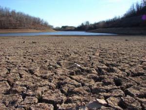
California drought causing land to sink // Source: commons.wikimedia.com
As Californians continue pumping groundwater in response to the historic drought, the California Department of Water Resources (DWR) the other day released a new NASA report showing land in the San Joaquin Valley is sinking faster than ever before, nearly two inches (five centimeters) per month in some locations. The report, Progress Report: Subsidence in the Central Valley, California, prepared for DWR by researchers at NASA’s Jet Propulsion Laboratory (JPL), Pasadena, California, is available here.
“Because of increased pumping, groundwater levels are reaching record lows — up to 100 feet (30 meters) lower than previous records,” said Department of Water Resources director Mark Cowin. “As extensive groundwater pumping continues, the land is sinking more rapidly and this puts nearby infrastructure at greater risk of costly damage.”
NASA says that sinking land, known as subsidence, has occurred for decades in California because of excessive groundwater pumping during drought conditions, but the new NASA data show the sinking is happening faster, putting infrastructure on the surface at growing risk of damage.
NASA obtained the subsidence data by comparing satellite images of Earth’s surface over time. Over the last few years, interferometric synthetic aperture radar (InSAR) observations from satellite and aircraft platforms have been used to produce maps of subsidence with approximately centimeter-level accuracy. For this study, JPL researchers analyzed satellite data from Japan’s PALSAR (2006 to 2010); and Canada’s Radarsat-2 (May 2014 to January 2015), and then produced subsidence maps for those periods. High-resolution InSAR data were also acquired along the California Aqueduct by NASA’s Uninhabited Aerial Vehicle Synthetic Aperture Radar (UAVSAR) (2013 to 2015) to identify and quantify new, highly localized areas of accelerated subsidence along the aqueduct that occurred in 2014.
The California Aqueduct is a system of canals, pipelines, and tunnels that carries water collected from the Sierra Nevada Mountains and Northern and Central California valleys to Southern California.
Using multiple scenes acquired by these systems, the JPL researchers were able to produce time histories of subsidence at selected locations, as well as profiles showing how subsidence varies over space and time.