Coastal resilienceRestoring and sustaining Louisiana’s eroding coast
Measures taken over the last ninety years to prevent a repetition of the 1927 New Orleans flood — the construction of improved levees, spillways, and dams as well as associated flood and additional navigation management structures designed to contain overflows and manage and stabilize a deep-water channel – have starved adjacent wetlands of the freshwater and sediment needed to stave off the Gulf of Mexico’s rising tides. The resulting land loss across the Delta is leading toward catastrophic collapse. Over the last century, almost 1,900 square miles of deltaic wetlands, an area approximately the size of Delaware, have disappeared from Louisiana. Every hour, a football field-sized swath of land drowns in the Gulf’s advancing tides. A Louisiana independent initiative, with the support and participation of the State of Louisiana and U.S. Army Corps of Engineers, has called on experts from the private sector to develop and assess new designs for the Lower Mississippi River (below New Orleans). The winning proposals were announced last week.
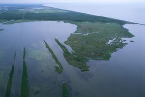
Louisiana wetland among the fastest disappearing // Source: ucsb.edu
Since the mid-eighteenth century, residents of New Orleans and other river settlements in the Delta built levees to protect themselves from flooding. The flood of 1927, at the time the largest and most disastrous in the history of the Lower Mississippi Valley, prompted interventions, including the construction of improved levees, spillways, and dams as well as associated flood and additional navigation management structures designed to contain overflows and manage and stabilize a deep-water channel.
Changing Course, an independent initiative dedicated to restoring the health and viability of the Lower Mississippi River Delta, says that measures taken to contain the River starved adjacent wetlands of the freshwater and sediment needed to stave off the Gulf of Mexico’s rising tides. The Delta has grown so far into the Gulf that the River’s mouth is at the edge of the continental shelf. As a result, the 120 million tons of sediment the River carries ends up in deep water, where it is lost forever.
The situation has been exacerbated by regional subsidence – that is, sinking of the land — associated with human and natural forces, and compounded further by sea-level rise and the increased volatility and severity of weather events due to global climate change.
The resulting land loss across the Delta is leading toward catastrophic collapse. Over the last century, almost 1,900 square miles of deltaic wetlands, an area approximately the size of Delaware, have disappeared from Louisiana. Every hour, a football field-sized swath of land drowns in the Gulf’s advancing tides. Without action, by 2100 Louisiana will have lost virtually all of its coastal wetlands.
At the same time, maintaining the shipping channel and flood protection for coastal communities has proved an increasingly costly challenge. The transportation and shipping industries, critical to the regional and national economies, depend on a functioning Mississippi River navigation system. In order to maintain that system, the same sediment which is needed for rebuilding land is dredged and discarded in order to preserve a sufficient River depth — an ever more difficult, expensive, and wasteful practice.
Simply put, the sediment that is the life source of the Delta is, and has always been, an impediment for navigation.