-
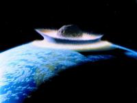
Nuclear weapons might save the world from an asteroid strike – but we need to change the law first
The schlocky 1998 Bruce Willis movie Armageddon was the highest grossing film of that year. The blockbuster saw a master oil driller (Willis) and an unlikely crew of misfits place a nuclear bomb inside a giant asteroid heading for Earth, blow it up – and save humanity. Armageddon isn’t exactly a documentary: it’s packed full of sci-fi nonsense. But, 20 years on, its basic plot – of using a nuclear explosion to avert a cataclysmic asteroid collision – doesn’t seem quite as silly as it did at the time.
-
-
Celestial menace: Defending Earth from asteroids
Incoming asteroids have been scarring our home planet for billions of years. This month humankind left our own mark on an asteroid for the first time: Japan’s Hayabusa2 spacecraft dropped a copper projectile at very high speed in an attempt to form a crater on asteroid Ryugu. A much bigger asteroid impact is planned for the coming decade, involving an international double-spacecraft mission.
-
-
Hurricane Maria's extreme rainfall due mostly to human-caused climate change
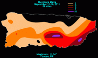
Hurricane Maria dropped more rain on Puerto Rico than any storm to hit the island since 1956, a feat due mostly to the effects of human-caused climate warming, new research finds.
-
-
Climate change: Our greatest national security threat?
The climate century is here: the earth is warming, humans are to blame, and we must take immediate action now to prepare for climate change’s massively disruptive consequences. Mark Nevitt writes in Just Security that No longer can climate change be categorized solely as an environmental issue—it is a grave threat to national security. Indeed, it may be the threat. While there are many national security challenges facing the nation and the world, climate change is an aptly described “super wicked” problem that exacerbates and accelerates already existing threats.
-
-
Environmental “secondary perils” an increasing threat: Swiss Re
The catastrophe loss experience of the last two years is a wake-up call for the insurance industry, highlighting a trend of growing devastation wreaked by so-called ‘secondary perils’ – which are independent small to mid-sized events, or secondary effects of a primary disaster.
-
-
Defending the Earth from asteroids
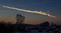
A mere 17-20 meters across, the Chelyabinsk meteor caused extensive ground damage and numerous injuries when it exploded on impact with Earth’s atmosphere in February 2013. To prevent another such impact, researchers use a simple yet ingenious way to spot these tiny near-Earth objects (NEOs) as they hurtle toward the planet.
-
-
Sensing earthquakes in a new way to help improve early warning systems
Every year earthquakes worldwide claim hundreds or even thousands of lives. Forewarning allows people to head for safety and a matter of seconds could spell the difference between life and death. Researchers demonstrate a new earthquake detection method — their technique exploits subtle telltale gravitational signals traveling ahead of the tremors. Future research could boost early warning systems.
-
-
Accurately predicting harmful space weather’s “killer” electrons

A new space weather model reliably predicts space storms of high-energy particles that are harmful to many satellites and spacecraft orbiting in the Earth’s outer radiation belt. The model can accurately give a one-day warning prior to a space storm of ultra-high-speed electrons, often referred to as “killer” electrons because of the damage they can do to spacecraft such as navigation, communications, and weather monitoring satellites.
-
-
Is Texas leading on disaster preparedness? Yes and no, experts say
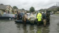
During the first legislative session since Hurricane Harvey, state lawmakers are poised to make an investment in storm recovery and flood mitigation that some have described as unprecedented. But it’s more complicated than that.
-
-
Why the Great Plains has such epic weather
From 78 degrees on Tuesday to snow on Wednesday? Swings like this aren’t unusual in the central United States, where weather can quickly shift from one extreme to another. What generates such “big weather” on the Great Plains?
-
-
Preparing San Francisco for future storms
The San Francisco Bay Area has been pummeled this winter by storms packed with moisture from atmospheric rivers. San Francisco is partnering with the Berkeley Lab to assess how climate change may influence the intensity of atmospheric rivers and associated precipitation, and how those changes may impact San Francisco and its infrastructure.
-
-
Stern warning: Climate expert emphasizes the fierce urgency of now
Prominent economist and policymaker Lord Nicholas Stern delivered a strong warning about the dangers of climate change in a talk at MIT on Tuesday, calling the near future “defining” and urging a rapid overhaul of the economy to reach net zero carbon emissions. “The next 20 years will be absolutely defining,” Stern told the audience, saying they “will shape what kind of future people your age will have.”
-
-
Predicting, understanding urban flooding
Flooding is the natural hazard with the greatest economic and social impact on the population of the United States. Urban flooding is a complex and distinct kind of flooding, compounded by land use and high population density, and it requires a different approach to assess and manage.
-
-
Owners of unprotected coastal homes don’t rush to retrofit
Many coastal homes have significant structural vulnerabilities that leave homeowners and their homes largely unprotected from storms. Additionally, the majority of coastal homeowners have little to no intention of reducing these structural vulnerabilities, even though they live in areas frequently affected by damaging hurricanes and flooding.
-
-
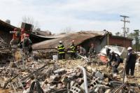
Driving force of volcanic super-hazards uncovered
Volcanologists have discovered the driving force behind superheated gas-and-ash clouds from volcanic eruptions, which may help save lives and infrastructure around the globe. Endangering 500 million people worldwide, pyroclastic density currents (or pyroclastic flows) are the most common and lethal volcanic threat, causing 50 percent of fatalities caused by volcanic activity.
-
The long view
The Surprising Reasons Floods and Other Disasters Are Deadlier at Night
It’s not just that it’s dark and people are asleep. Urban sprawl, confirmation bias, and other factors can play a role.
Why Flash Flood Warnings Will Continue to Go Unheeded
Experts say local education and community support are key to conveying risk.