-
Relying on geoengineering to reduce climate change unlikely to succeed
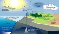
Reducing the amount of sunlight reaching the planet’s surface by geoengineering may not undo climate change after all. Researchers used a simple energy balance analysis to explain how the Earth’s water cycle responds differently to heating by sunlight than it does to warming due to a stronger atmospheric greenhouse effect. Further, they show that this difference implies that reflecting sunlight to reduce temperatures may have unwanted effects on the Earth’s rainfall patterns.
-
-
Urgent action needed to save the Great Plains water supply
Significant portions of the Ogallala Aquifer, one of the largest bodies of water in the United States, are at risk of drying up if it continues to be drained at its current rate.The body of water, also known as the High Plains Aquifer, spans from Texas to South Dakota and drives much of the region’s economy. Scientists are proposing alternatives that will halt and hopefully reverse the unsustainable use of water drawdown in the aquifer.
-
-
Risk of earthquake/tsunami in Caribbean higher than previously thought
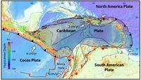
Enough strain may be currently stored in an earthquake zone near the island of Guadeloupe to cause a magnitude 8 or larger earthquake and subsequent tsunami in the Caribbean, according to a new U.S. Geological Survey study.
-
-
Carbon capture technology vital for meeting climate targets
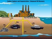
In 2010, coal, oil, and gas supplied more than 80 percent of the world’s total primary energy supply — and the demand for energy is projected to increase by two to three times by 2100. Studies show that without policies to cut greenhouse gas emissions, fossil fuels will remain the major energy source in 2100, with resulting increases in greenhouse gas emissions. Where should policymakers focus their carbon mitigation efforts, however? Which technologies hold the most promise?Scientists say that a combination of carbon capture and storage (CCS) and bioenergy has advantages over solar, wind, and nuclear because it can lead to negative emissions. Moreover, bioenergy can be converted into liquid and gaseous fuels which are easily storable and can be readily used by current transportation systems,thus taking some pressure off other sector in terms of required mitigation effort.
-
-
World's shrinking groundwater sources in urgent need of better governance

Groundwater makes up 97 per cent of the world’s available fresh water. Total global use is estimated by scientists at around 1,000 cubic kilometers a year, with the largest users being India, China, and the United States. Since 1900, the world has drawn down its groundwater reserves by an estimated 4,500 cubic kilometers — and demand continues to increase, especially in arid countries, which are rapidly running short of water that can be affordably extracted. Scientist has urged the world to take better care of its groundwater resources — or risk dangerous scarcities, economic impacts, and potential conflicts in coming decades.
-
-
Sun not a key cause of climate change

Climate change has not been strongly influenced by variations in heat from the sun, a new scientific study shows. The findings overturn a widely held scientific view that lengthy periods of warm and cold weather in the past might have been caused by periodic fluctuations in solar activity.
-
-
Curbing climate change requires more attention to livestock
While climate change negotiators struggle to agree on ways to reduce carbon dioxide (CO2) emissions, they have paid inadequate attention to other greenhouse gases associated with livestock. Researchers say that cutting releases of methane and nitrous oxide, two gases that pound-for-pound trap more heat than does CO2, should be considered alongside the challenge of reducing fossil fuel use. Ruminant livestock (cattle, sheep, goats, and buffalo) produce copious amounts of methane in their digestive systems. CO2 is the most abundant greenhouse gas, but the international community could achieve a more rapid reduction in the causes of global warming by lowering methane emissions through a reduction in the number of ruminants, the researchers say, than by cutting CO2 alone.
-
-
Natural gas saves water, reduces drought vulnerability
A new study finds that in Texas, the U.S. state that annually generates the most electricity, the transition from coal to natural gas for electricity generation is saving water and making the state less vulnerable to drought. Even though exploration for natural gas through hydraulic fracturing requires significant water consumption in Texas, the new consumption is easily offset by the overall water efficiencies of shifting electricity generation from coal to natural gas. The researchers estimate that water saved by shifting a power plant from coal to natural gas is 25 to 50 times as great as the amount of water used in hydraulic fracturing to extract the natural gas.
-
-
Freshwater loss compounds climate change’s detrimental effects on agriculture
A warmer world is expected to have severe consequences for global agriculture and food supply, reducing yields of major crops even as population and demand increases.Agricultural models estimate that given the present trajectory of greenhouse gas emissions, climate change will directly reduce food production from maize, soybeans, wheat, and rice by as much as 43 percent by the end of the twenty-first century. Now, a new analysis combining climate, agricultural, and hydrological models finds that shortages of freshwater used for irrigation could double the detrimental effects of climate change on agriculturedue to the reversion of twenty to sixty million hectares of currently irrigated fields back to rain-fed crops.
-
-
Sea level rise, shoreline changes leading influences on flooding from hurricanes
Recent studies into coastal flooding have focused on climate change impacts on the intensity and frequency of tropical cyclones themselves, but researchers say that two other factors contribute even more to the growing threats to coastal communities: sea level rise and shoreline retreat. Researchers highlight sea level rise and its potential dramatically to change the coastal landscape through shoreline erosion and barrier island degradation, and say that it is an under-appreciated and understudied factor that could lead to catastrophic changes in flood risk associated with tropical cyclones, known as hurricanes in the North Atlantic.
-
-
Exploring geoengineering research, ethics, governance
Hacking the Earth’s climate to counteract global warming — a subject that elicits strong reactions from both sides — is the topic of a December special issue of the journal Climatic Change. A dozen research papers include the most detailed description yet of the proposed Oxford Principles to govern geoengineering research, as well as surveys on the technical hurdles, ethics, and regulatory issues related to deliberately manipulating the planet’s climate.
-
-
Japan tsunami exacerbated by landslide

The 2011 Japan tsunami, which killed up to 20,000 people and caused the partial meltdown of the Fukushima nuclear plant, was made worse by an underwater landslide, according to scientists. “The earthquake alone cannot explain the height of the waves along the Sanriku coast of northern Honshu Island,” says one scientist. “They were generated by a submarine landslide.” The research poses a big problem for early-warning systems, because where the risk of landslides goes unrecognized, tsunamis generated by similar earthquakes could be seriously underestimated.
-
-
Enjoy it while you can: 850 million more years before oceans boil away

Scientists had estimated that the Earth’s oceans would boil away in about 150 million years. The reason: the sun expands as it runs out of hydrogen fuel, and that expansion, 150 million years from now,would cause “runaway” global warming leading to the boiling of the oceans. Scientists have now found that the Earth’s “Goldilocks Zone” — where it is neither too hot nor too cold for liquid to exist on a planet orbiting a star— is slightly larger than previously thought, meaning Earth has bought itself some additional time — about 700 million years – before the oceans evaporate.
-
-
Uranium found to be mobile in a natural wetland
Because they are known to mop up pollutants, artificial wetlands are considered to be an efficient strategy to contain waterborne uranium. Studying a natural wetland near a former uranium-mining site in the French region of Limousin, however, researchers have found that under certain circumstances, uranium can be partly remobilized into the surrounding water. The researchers show how it becomes mobile again by binding to tiny metallic and organic compounds with a little help from ambient bacteria.
-
-
Collapse of the universe closer than previously thought
Maybe it happens tomorrow. Maybe in a billion years. Physicists have long predicted that the universe may one day collapse, and that everything in it will be compressed to a small hard ball. New calculations by physicists now confirm this prediction — and they also conclude that the risk of a collapse is even greater than previously thought.
-
- All
- Regional
- Water
- Biometrics
- Borders/Immig
- Business
- Cybersecurity
- Detection
- Disasters
- Government
- Infrastructure
- International
- Public health
- Public Safety
- Communication interoperabillity
- Emergency services
- Emergency medical services
- Fire
- First response
- IEDs
- Law Enforcement
- Law Enforcement Technology
- Military technology
- Nonlethal weapons
- Nuclear weapons
- Personal protection equipment
- Police
- Notification /alert systems
- Situational awareness
- Weapons systems
- Sci-Tech
- Sector Reports
- Surveillance
- Transportation
Advertising & Marketing: advertise@newswirepubs.com
Editorial: editor@newswirepubs.com
General: info@newswirepubs.com
2010-2011 © News Wire Publications, LLC News Wire Publications, LLC
220 Old Country Road | Suite 200 | Mineola | New York | 11501
Permissions and Policies
Editorial: editor@newswirepubs.com
General: info@newswirepubs.com
2010-2011 © News Wire Publications, LLC News Wire Publications, LLC
220 Old Country Road | Suite 200 | Mineola | New York | 11501
Permissions and Policies