-
Cyberweapons likely to be an integral part of any U.S.-Syria clash
A U.S.-led military attack on Syria may have been averted, at least for a while, by the Russian proposal to negotiate the transfer of Syria’s chemical weapons stocks to international control, but had the United States gone ahead with a strike, there is little doubt that cyberattacks would have been used by both sides. If the United States decides to attack Syria in the future, we should expect cyberweapons to be used.
-
-
Cold-formed steel rebuilds earthquake-resistant architecture
When engineers attempt to make a building earthquake-resistant, they use specific structural components, appropriately called details, to absorb earthquake forces and help direct some of those forces back to the ground. That works, but when an earthquake hits, the entire building reacts, not just the sections containing details. Even though academic research has led to improvements to the original building codes over the decades, there is much to be learned about the entire system of a cold-formed steel building as it responds to an earthquake.
-
-
New technique developed to assess the cost of major flood damage
A new approach to calculating the cost of damage caused by flooding was presented at the International Conference of Flood Resilience: Experiences in Asia and Europe which was held last week. The methodology combines information on land use with data on the vulnerability of the area to calculate the cost of both past and future flooding events.
-
-
“Climate Change, Water Conflicts, and Human Security” report released
Increasingly, climate change and the associated increase in the frequency of extreme weather events such as floods, droughts, and rising sea level, are acknowledged as not only having humanitarian impacts, but also creating national and regional political and security risks. While people and governments can adapt to these impacts, their capacity to do so varies.
-
-
Study links prehistoric climate shift to asteroid or comet impact
For the first time, a dramatic climate shift which has long fascinated scientists has been linked to the impact in Quebec of an asteroid or comet. The event took place about 12,900 years ago, at the beginning of the Younger Dryas period, and marks an abrupt global change to a colder, dryer climate, with far-reaching effects on both animals and humans.
-
-
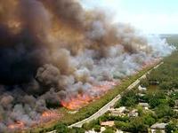
Global warming increasing risk of record heat: scientists
Drought shriveled crops in the Midwest, massive wildfires raged in the West, and East Coast cities sweltered. The summer of 2012 was a season of epic proportions, especially July, the hottest month in the history of U.S. weather record keeping. As the world warms, it is likely that we will continue to see such calamitous weather. Scientists caution against trying to determine whether global warming caused any individual extreme event, but they say that the observed global warming clearly appears to have affected the likelihood of record heat.
-
-
High performance concrete to rescue Brittany's lighthouses

Lighthouses in Brittany, France, have stood at the intersection of violent currents, blinding storms, and breaking surf for over a century. A lighthouse turret off the coast of Lorient in Brittany has been enhanced with technology developed for bridges. This trial run will test the application of Ultra-High Performance Concrete (UHPC).
-
-
Limestone powder enhances performance of “green” concrete
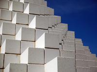
Adding limestone powder to “green” concrete mixtures — those containing substantial amounts of fly ash, a byproduct of coal-burning power plants — can significantly improve performance. The promising laboratory results suggest a path to increasing greatly the use of fly ash in concrete, leading to sizable reductions in greenhouse gas emissions, energy use, construction costs and landfill volumes.
-
-
Knowing exposure risks crucial to saving structures from wildfires
A recent study of one of California’s most devastating wildland fires strongly suggests that measures for reducing structural damage and property loss from wildland urban interface (WUI) fires are most effective when they are based on accurate assessments of exposure risks both for individual structures and the community as a whole.
-
-
U.S. “black budget” reveals unwieldy bureaucracy, misplaced priorities: expert
Classified budget figures and successes and failures by American intelligence agencies, exposed for the first time this week by the Washington Post, show a massive bureaucracy with misplaced priorities, according to a cybersecurity and privacy expert. “The major failure identified in all of the post-9/11 assessments was a ‘failure to connect the dots,’” the expert said. “Nevertheless, the vast majority of the black budget is being spent on data acquisition — collecting more dots — rather than analysis.”
-
-
Deflecting asteroids to protect Earth
Potential asteroid impact on Earth can have disastrous consequences. In order to prevent such collisions, earthbound space objects must be deflected. This can be accomplished using a space probe to impact the asteroid.
-
-
Sandy Task Force issues sixty-nine rebuilding recommendations
The Hurricane Sandy Rebuilding Task Force, appointed by President Obama and chaired by Housing and Urban Development secretary Shaun Donovan, last week release its much-anticipated report, in which it lays out sixty-nine policy recommendations for improving areas affected by Hurricane Sandy last October. The report stressed the importance of investment in new and better construction to withstand increasingly dangerous storms and surges caused by climate change.
-
-
Jersey shore towns build protection against future storms
Mantoloking and Brick townships in New Jersey were among the hardest hit by Superstorm Sandy. The storm also destroyed the natural dune barriers which offered a measure of protection. The two cities have decided to take action to minimize the damage of inflicted by a future storm: a $40 million project will see a steel wall —extending sixteen feet above the beach with a depth of thirty-two feet below the ground, and covered in sand to form an artificial dune — will run along the length of the two towns.
-
-
Understanding the effects of wildfire smoke improves climate change models
Where there is wildfire, there is smoke — a lot of it. Those vast, carbon-laden clouds released by burning biomass can play a significant role in climate change. Not much is known, however, about the different types of particles in wildfire smoke and how they affect climate. Now researchers have uncovered some of their secrets. In particular, they studied an important component of smoke that has so far been absent from most models of climate change.
-
-
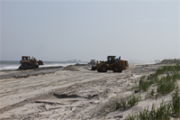
Beach erosion by Hurricane Sandy leaves coastal communities more exposed to future storms
Barrier islands provide natural protection against storms, shielding coastlines from rising waves and tides. Beaches and dunes on Fire Island, New York, lost more than half of their pre-storm volume during Hurricane Sandy, and the loss of so much sand increases the vulnerability of this area of coastline to future storms.
-
- All
- Regional
- Water
- Biometrics
- Borders/Immig
- Business
- Cybersecurity
- Detection
- Disasters
- Government
- Infrastructure
- International
- Public health
- Public Safety
- Communication interoperabillity
- Emergency services
- Emergency medical services
- Fire
- First response
- IEDs
- Law Enforcement
- Law Enforcement Technology
- Military technology
- Nonlethal weapons
- Nuclear weapons
- Personal protection equipment
- Police
- Notification /alert systems
- Situational awareness
- Weapons systems
- Sci-Tech
- Sector Reports
- Surveillance
- Transportation
Advertising & Marketing: advertise@newswirepubs.com
Editorial: editor@newswirepubs.com
General: info@newswirepubs.com
2010-2011 © News Wire Publications, LLC News Wire Publications, LLC
220 Old Country Road | Suite 200 | Mineola | New York | 11501
Permissions and Policies
Editorial: editor@newswirepubs.com
General: info@newswirepubs.com
2010-2011 © News Wire Publications, LLC News Wire Publications, LLC
220 Old Country Road | Suite 200 | Mineola | New York | 11501
Permissions and Policies