-
April 2012 Indian Ocean earthquake indicate s that a new tectonic plate is being born
The 11 April 2012 8.7 magnitude earthquake in the Indian Ocean, unlike its 2004 predecessor, did very little damage; it began at one fault, and when it reached an intersecting fault, it ruptured; in total, four different faults were ruptured over the course of 150 seconds; when earthquakes spread to connecting faults, the rupture rips along faults that branch away from the initial fault like branches of a river; the April 2012 earthquakes took a very different course, running along grid-like patterns and making 90 degree turns; the weird rupture pattern reflects the fact that the region is giving birth to a new tectonic plate
-
-
China’s infrastructure is failing owing to sub-standard materials, corruption, and lax regulation
Shoddy infrastructure in China has put people in danger time and time again; many of the infrastructure issues in China stem from the government’s focus on quantity over quality, as well as making sure that as many people are employed as possible for a project, rather than using the latest construction technology; sub-standard materials, corruption, and lax regulation only exacerbate the problem
-
-
City of Ottawa sits atop soft soil, a geologic features which amplifies seismic waves

Roughly 20 percent of the Ottawa area is built on bedrock, while the remaining area contains unconsolidated surface deposits; this is not good news for city planners – and dwellers – because soft soil amplifies seismic waves, resulting in stronger ground motion than for sites built over bedrock
-
-
Keeping safe during earthquakes? There’s an app for that
The American Red Cross released its official earthquake application for iPhone and Android smartphones; the app is free, available in English or Spanish; the app includes earthquake epicenter locations, impact magnitudes, and local geographical impact data provided by the U.S. Geological Survey; it also includes a “shake zone” impact map and a one touch “I’m safe” messaging
-
-
Risky business: Modeling catastrophes
The probability that a given natural hazard could become a natural disaster is higher today than at any previous point in history, largely because of population growth putting more people and infrastructure in harm’s way
-
-
BART to adopt earthquake early warning system
Thanks to assistance from the Berkeley Seismological Laboratory, the San Francisco Bay Area Rapid Transit (BART) system can now automatically brake trains when earthquakes threaten to rattle the Bay Area, allowing perhaps tens of seconds to a minute for trains to slow down before the ground starts to shake
-
-
Chile relies on new technologies to cope with frequent earthquakes
Citizens of Chile are used to the ground shaking beneath their feet; in the past two years alone Chile has experienced more than forty earthquakes with magnitudes of six or higher; with so many earthquakes and the potential of thousands dying yearly, Chilean authorities are using new methods to protect their citizens from death and buildings from damage
-
-
Hurricane Irene polluted Catskills watershed
The water quality of lakes and coastal systems will be altered if hurricanes intensify in a warming world, according to a Yale study; researchers found that last summer during Hurricane Irene — the worst storm in the New York area in 200 years — record amounts of dissolved organic matter darkened Catskill waters and affected the Ashokan Reservoir that supplies New York City with drinking water
-
-
Large 11 April 2012 earthquake triggered temblors worldwide for a week
This year’s largest earthquake, a magnitude 8.6 temblor on 11 April centered in the East Indian Ocean off Sumatra, did little damage, but it triggered quakes around the world for at least a week; the findings are a warning to those living in seismically active regions worldwide that the risk from a large earthquake could persist — even on the opposite side of the globe — for more than a few hours
-
-
Debate over causes of levee failure during Katrina intensifies
A court case in which residents of two sections of New Orleans are suing a construction group has put millions of dollars at stake; residents of the Lower 9th Ward and St. Bernard Parish residents claim that Washington Group International (WGI), an Amy Corps of Engineers contractor, removed several buildings and pilings from land along the Industrial Canal as part of a construction plan to expand the canal’s shipping lock, then failed adequately to plug the holes left behind; the holes allowed rainwater from Hurricane Katrina to seep underneath the 14-foot wall, essentially lifting the wall and allowing the areas to be flooded
-
-
Dutch test-levee experiment helps strengthen U.S. levees, dams
In the United States, the national flood-control infrastructure is aging and its structural health is deteriorating; the system comprises more than 5,600 km of levees, and 43 percent of the U.S. population lives in counties with levees designed to provide some level of protection from flooding; some of these levees are as old as 150 years; in 2009, the American Society of Civil Engineers Report Card for America’s Infrastructure gave the condition of the nation’s dams a grade of D, and levees a grade of D-minus; an dam-strength experiment in the Netherland helps engineers collect data to validate new suite of technologies for assessing the health of levees and dams
-
-
New York unprepared for flooding, sea level rise
New York City may be a fast paced city of bright lights, sleek attitudes, fashion trends, and some of the best sports teams in the country, but underneath the glitz and glamour is a city which is not prepared for an act of God and which is being threatened by rising sea levels and severe storm flooding; “It’s a million small changes that need to happen,” one expert says
-
-
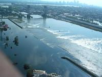
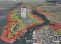
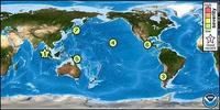
Seventy-four nuclear reactors in tsunami-risk areas
Researchers have, for the first time, identified those nuclear power plants which are more vulnerable to suffering the effects of a tsunami; in total, twenty-three plants, in which there are seventy-four active nuclear reactors, are located in dangerous areas in east and southeast of Asia
-
-
New law aims to make Istanbul earthquake-safe, but it has its critics
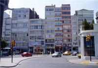
Estimates of Istanbul’s population range from twelve and nineteen million people, a significant increase from two million people fiftyyears ago; during the waves of migration to Istanbul during the 1960s,1970s, and 1980s, the government gave citizens free permitsto add to their homes, which resulted in single-story residents becoming 4-or 5-story buildings on unstable foundations; Istanbul sits only thirteen miles north of the North Anatolian Fault, the intersection of the Eurasian and Anatolian plates, and has been subject to devastating earthquakes; new, controversial law aims to make Istanbul’s buildings earthquake-safe
-
The long view
The Surprising Reasons Floods and Other Disasters Are Deadlier at Night
It’s not just that it’s dark and people are asleep. Urban sprawl, confirmation bias, and other factors can play a role.
Why Flash Flood Warnings Will Continue to Go Unheeded
Experts say local education and community support are key to conveying risk.