-
Surveillance blimps raise privacy concerns
Some 10,000 feet in the air above the Aberdeen Proving Ground in Maryland, the Pentagon has been testing its Joint Land Attack Cruise Missile Elevated Netted Sensor System (JLENS), meant to identify low-flying cruise missiles within a few hundred miles. Supporters of the program say that as cruise missiles become more widely available to U.S. enemies, the aerostats will become a preferred defense option, providing long-range radar much more consistently and cheaply than systems mounted on planes.Privacy advocates question whether privacy rights are being violated in the process.
-
-
FAA proposes rules for integrating drones into U.S. airspace
In an effort to integrate UAVs, or drones, into U.S. airspace, the Federal Aviation Administration (FAA) plans to allow small commercial drones weighing up to fifty-five pounds to fly within sight of their remote pilots during daylight hours, according to the agency’s proposal for governing commercial drone flights. The drones must remain below 500 feet in the air and not exceed 100 mph.Industry advocates warned that drone research could move overseas if the U.S. government fails to quickly accept the widespread use of commercial drones.
-
-
Before-and-after aerial imagery of infrastructure to help first responders
When disaster strikes, it is important for responders and emergency officials to know what critical infrastructure has been damaged so they can direct supplies and resources accordingly. Researchers are developing a program that uses before-and-after aerial imagery to reveal infrastructure damage in a matter of minutes.
-
-
No technologies currently available to track, disable small drones
Monday’s drone incident on the White House lawn exposed a security gap that Secret Service and counterterrorism officials have been studying for years, but for which they have yet to develop a solution. Four days before the incident, lawmakers examining White House security protocols in response to a series of intrusions, were warned by a panel of experts that the Secret Service’s inability to identify and disable drones remained a top vulnerability, according to people with knowledge of the discussions.Security experts say proposals for a higher fence around the White House, together with increased surveillance and environmental sensors, are not enough to easily to identify and disable a drone before it lands.
-
-
CODE program would allow UAVs to fly as collaborative teams
The U.S. military’s investments in unmanned aircraft systems (UAS) have proven invaluable for missions from intelligence, surveillance, and reconnaissance (ISR) to tactical strike. Most of the current systems, however, require constant control by a dedicated pilot and sensor operator as well as a large number of analysts, all via telemetry. These requirements severely limit the scalability and cost-effectiveness of UAS operations and pose operational challenges in dynamic, long-distance engagements with highly mobile targets in contested electromagnetic environments. DARPA’s CODE program is offering the opportunity to participate in discussions to help develop groundbreaking software enabling unmanned aircraft to work together with minimal supervision.
-
-
New technology proves effective in thwarting cyberattacks on drones
Engineering researchers from the University of Virginia and the Georgia Institute of Technology have successfully flight-tested scenarios which could threaten drones, including ground-based cyber-attacks. The demonstration of U.Va’s System-Aware Cybersecurity concept and Secure Sentinel technology was part of a research project led by U.Va. engineers to detect and respond to cyber-attacks on unmanned aerial systems.
-
-
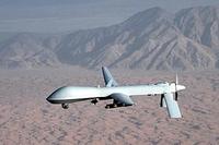
Terrorists develop tactics to evade U.S. drones
The CIA’s use of Predator drones against Islamic militants in the Middle East began shortly after the 9/11 attacks and has increased dramatically during the Obama administration. As the number of drone strikes in Yemen increased, AQAP militants began to develop tactics to hide themselves from a drone’s sensors.
-
-
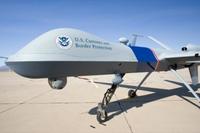
DHS IG questions value of CBP’s border drone program
DHS’s 8-years-old drone program, now consisting of nine drones operating in Arizona, Texas, and North Dakota, has been unsuccessful, according to a just-released DHS inspector general report. Customs and Border Patrol(CBP) expected 23,000 total flight hours per year, but it only logged about 5,100 in fiscal year 2013. The inspector general’s report notes that drones helped in less than 2 percent of apprehensions of illegal immigrants.CBP has used the dronesto cover just 170 miles of the U.S. border – and a 2014 GAO report noted that a fifth of CBP drone flights were conducted within the interior of the United States and beyond the 100-mile range of operations of CBP jurisdiction points.
-
-
Speedy, agile UAVs for troops in urban missions
DARPA aims to give small unmanned aerial vehicles (UAVs) advanced perception and autonomy rapidly to search buildings or other cluttered environments without teleoperation. The program aims to develop and demonstrate autonomous UAVs small enough to fit through an open window and able to fly at speeds up to twenty meters per second (45 miles per hour) — while navigating within complex indoor spaces independent of communication with outside operators or sensors and without reliance on GPS waypoints.
-
-
FAA would allow four private companies to operate drones in U.S. airspace
The Federal Aviation Administration(FAA) announced the other day that it would allow four private companies to operate drones in U.S. airspace. The drones will be used to survey land, inspect remote oil rigs, perform agricultural and environmental research, monitor construction projects, and collect geographical data. The FAA has banned most drone flights as they pose a risk to the safety of manned aircrafts, and in some cases to privacy. The drone industry says that if drones are integrated into U.S. civilian airspace, the domestic economic impact would surpass $82.1 billion between 2015 and 2025, while creating more than 100,000 high-paying jobs.
-
-
University of Maryland opens new drone test facility
The University of Maryland has recently opened a new drone test site on the Eastern Shore which will allow researchers and students to help in the safe development of drones for use in U.S. airspace. The university will partner with companies to develop projects in a safe space. Already there are plans to use drones to monitor fish populations in the nearby Chesapeake Bay, examine power lines in the southern part of the state, and perform jobs which are considered “dirty, dull [or] dangerous,” in the words of the head of the facility.
-
-
Smaller lidars could be mounted on UAVs for underwater scans

Bathymetric lidars — devices which employ powerful lasers to scan beneath the water’s surface — are used today primarily to map coastal waters. At nearly 600 pounds, the systems are large and heavy, and they require costly, piloted aircraft to carry them. Georgia Tech Research Institute (GTRI) researchers have designed a new approach that could lead to bathymetric lidars that are much smaller and more efficient than the current full-size systems. The new technology would let modest-sized unmanned aerial vehicles (UAVs) carry bathymetric lidars, lowering costs substantially. These advanced capabilities could support a range of military uses such as anti-mine and anti-submarine intelligence and nautical charting, as well as civilian mapping tasks. In addition, the new lidar could probe forested areas to detect objects under thick canopies.
-
-
Satellites help assess risk of epidemics
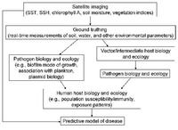
Changes in the environment, global trade, and travel are all factors in the ever-increasing numbers and movement of pests. Identifying and predicting the distribution of existing local species as well as the spread of new exotic ones are essential in assessing the risk of potential epidemics. Researchers have developed Vecmap — an all-encompassing software and services package including a smartphone app for field studies with a time and location information system, all linked to an online database. The database pools satellite information with results from field research, and satnav adds location information. The new approach greatly reduces the complexity of tracking species compared to traditional methods.
-
-
Drones watch over U.S. borders
Since 2000, the number of Border Patrol agents on the 1,954-mile U.S.-Mexico border has more than doubled, to surpass 18,000, and fencing has increased nine times — to 700 miles. Some members of Congress and border state lawmakers are calling for more border agents and more fencing, but the Obama administration is looking to drones to help reduce the number of illegal immigrants and drugs entering the United States, while simultaneously shifting resources and agents to parts of the border where illegal activity is highest.
-
-
Legal framework needed to govern soon-to-arrive autonomous killer drones: Experts
With about 8,000 unmanned aircrafts and roughly 12,000 unmanned ground vehicles, the U.S. military boasts the world’s largest drone arsenal, followed by Israel, with China, Europe, India, and Russia in the second tier. Unmanned aerial vehicles (UAV) will pose a challenge to current international laws of warfare since someday, and sooner rather than later, they will be able to act autonomously – and kill autonomously. The international community has yet to adopt special laws to govern the use of drones in combat.
-
- All
- Regional
- Water
- Biometrics
- Borders/Immig
- Business
- Cybersecurity
- Detection
- Disasters
- Government
- Infrastructure
- International
- Public health
- Public Safety
- Communication interoperabillity
- Emergency services
- Emergency medical services
- Fire
- First response
- IEDs
- Law Enforcement
- Law Enforcement Technology
- Military technology
- Nonlethal weapons
- Nuclear weapons
- Personal protection equipment
- Police
- Notification /alert systems
- Situational awareness
- Weapons systems
- Sci-Tech
- Sector Reports
- Surveillance
- Transportation
Advertising & Marketing: advertise@newswirepubs.com
Editorial: editor@newswirepubs.com
General: info@newswirepubs.com
2010-2011 © News Wire Publications, LLC News Wire Publications, LLC
220 Old Country Road | Suite 200 | Mineola | New York | 11501
Permissions and Policies
Editorial: editor@newswirepubs.com
General: info@newswirepubs.com
2010-2011 © News Wire Publications, LLC News Wire Publications, LLC
220 Old Country Road | Suite 200 | Mineola | New York | 11501
Permissions and Policies