-
First responders drill response to a “Night of the Walking Dead” scenario

DHS funds were approved to pay the $1,000 fee for a week-long conference at Paradise Point Resort and Spa in San Diego; the marquee event of the summit was its highly-promoted “zombie apocalypse” demonstration; Strategic Operations, a tactical training firm, was hired to put on a “zombie-driven show” designed to simulate a real-life terrorism event; the firm performed two shows on Halloween, which featured forty actors dressed as zombies getting gunned down by a military tactical unit
-
-
Company illegally stores 6 million pounds of explosives, neighboring town evacuated
The 800 residents of the town of Doyline, located about 270 miles northwest of New Orleans, were hastily evacuated Friday, and may be forced to stay away until today (Tuesday), after the authorities found more the six million pounds of explosives illegally stored on the grounds of Camp Minden, which used to house the Louisiana Army Ammunitions Plant
-
-
Public safety networks coped better with Sandy than commercial networks
A new nationwide Long Term Evolution (LTE) network for first responders will be built under the supervision of the First Responder Authority (FirstNet); this network will be an improvement over the commercial networks that experienced outages during Hurricane Sandy
-
-
Tents provide disaster victims with shelter – and a measure of privacy
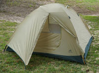
A charity called ShelterBox gives out tents and other essential equipment to victims of war and natural disasters around the world; the lightweight tents the charity provides can withstand winds of up to sixty-two miles per hour; the charity also provides thermal blankets, stoves, pans, utensils, tool-kits, and even crayons for children
-
-
Technology to help weather bushfires, floods and more
Natural disasters have increased in severity and frequency in recent years; in 2010, 385 natural disasters affected 217 million people worldwide at a cost to the global economy of $123.9 billion; there is an on-going research into digital technologies and services for disaster planning, preparation, rescue, and recovery; these technologies can help emergency services better manage natural disasters and minimize their effects on people, infrastructure, and the environment
-
-
New surveillance technologies for improved emergency management
Researchers are working to design and build resilient streaming sensor networks for emergency response such as bushfires; experts say the emergency services sector can significantly improve the availability of critical information better to manage incidents by exploiting new and emerging surveillance strategies
-
-
Flying robot avoids obstacles
Researchers have created an autonomous flying robot which is as smart as a bird when it comes to maneuvering around obstacles; able to guide itself through forests, tunnels, or damaged buildings, the machine could have tremendous value in search-and-rescue operations
-
-
"Stutter jump" could improve performance of search and rescue robots
A new study shows that jumping can be much more complicated than it might seem; in research that could extend the range of future rescue and exploration robots, scientists have found that hopping robots could dramatically reduce the amount of energy they use by adopting a unique two-part “stutter jump”
-
-
Approaches to international consequence management for CBRNE incidents
The National Research Council (NRC) of the National Academy of Sciences, through a grant sponsored by NIST’s Office of Law Enforcement Standards (OLES), is organizing an effort to understand the metrics and measures that are needed to develop standards of response that will support the basic capabilities of a country or region to respond to a chemical, biological, radiological, nuclear, or explosive (CBRNE) incident
-
-
Technology used in BioWatch could not detect pathogens, issued false alarms
The BioWatch program was created to detect the release of pathogens in the air as part of a terrorist attack, but scientists say that the program is unable to detect lethal germs because the system uses defective components; these components often set off false alarms; for example, BioWatch sensors issued fifty alarms between 2003 and 2008, but scientists and security authorities never had enough confidence in the BioWatch system to evacuate an area or take other emergency steps
-
-
The DARPA Robotics Challenge begins
The DARPA Robotics Challenge (DRC) began yesterday, and DARPA wants to know whether you will be part of it; DARPA introduces teams for Tracks A and B, opens registration for Tracks C and D, and launches simulation software for download; the goal of the competition is to help advance robotic technology to the point where it can have a tangible impact on humanitarian assistance and disaster relief
-
-
Mayor suggests student fee to hire more police, firefighters for local college’s sporting events
Morgantown, West Virginia mayor Jim Manilla wants to hire more police officers and firefighters to deal with street fires, riots, and other incidents following West Virginia University sporting events, and he wants the students to pay for it
-
-
Green laser pointer identifies traces of dangerous chemicals in real time
By using an ordinary green laser pointer, the kind commonly found in offices and college lecture halls, an Israeli research team has developed a new and portable Raman spectrometer which can detect minute traces of hazardous chemicals in real time; the new sensor’s compact design makes it a candidate for rapid field deployment to disaster zones and areas with security concerns
-
-
Imagining first responders’ high-tech future
What kinds of gear will be needed by future firefighters, EMTs, and police officers? DHS Science and Technology Directorate researchers asked the experts, then applied sophisticated math to discover unlikely patterns
-
-
New mobile app could save lives in earthquakes
A new iPhone app called has been developed to locate loved ones in the world’s earthquake zones during the event of an earthquake; the app, once downloaded, prompts users to enter their own details and those of four friends or family members in order to become their “Buddies”; in the event of an earthquake registering above 5.5, the user’s buddies will instantaneously receive an e-mail displaying a Google map of the user’s location
-
- All
- Regional
- Water
- Biometrics
- Borders/Immig
- Business
- Cybersecurity
- Detection
- Disasters
- Government
- Infrastructure
- International
- Public health
- Public Safety
- Communication interoperabillity
- Emergency services
- Emergency medical services
- Fire
- First response
- IEDs
- Law Enforcement
- Law Enforcement Technology
- Military technology
- Nonlethal weapons
- Nuclear weapons
- Personal protection equipment
- Police
- Notification /alert systems
- Situational awareness
- Weapons systems
- Sci-Tech
- Sector Reports
- Surveillance
- Transportation
Advertising & Marketing: advertise@newswirepubs.com
Editorial: editor@newswirepubs.com
General: info@newswirepubs.com
2010-2011 © News Wire Publications, LLC News Wire Publications, LLC
220 Old Country Road | Suite 200 | Mineola | New York | 11501
Permissions and Policies
Editorial: editor@newswirepubs.com
General: info@newswirepubs.com
2010-2011 © News Wire Publications, LLC News Wire Publications, LLC
220 Old Country Road | Suite 200 | Mineola | New York | 11501
Permissions and Policies