-
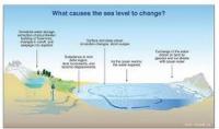
Sea level rise unevenly, which is bad news for some coastal regions
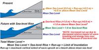
When you fill a sink, the water rises at the same rate to the same height in every corner. This is not the way it works with our rising seas. Tides, winds, and ocean currents play a role in these regional differences, but an increasingly important mover and shaker is the solid Earth itself. Global warming is not just affecting the surface of our world; it is making the Earth move under our feet. These regional differences in sea level change will become even more apparent in the future, as ice sheets melt. For instance, when the Amundsen Sea sector of the West Antarctic Ice Sheet is totally gone, the average global sea level will rise four feet. The East Coast of the United States, however, will see an additional fourteen to fifteen inches above that average.
-
-
Sea-level rise handbook to help land managers, coastal planners, and policy makers
Coastal managers and planners now have access to a new U.S. Geological Survey (USGS) handbook which, for the first time, comprehensively describes the various models used to study and predict sea-level rise and its potential impacts on coasts. The handbook, designed for the benefit of land managers, coastal planners, and policy makers in the United States and around the world, explains many of the contributing factors that account for sea-level change.
-
-
Experts urge negotiators to include water in climate agreement
The impact of climate change is felt through water, with flooding, erratic rain patterns, prolonged droughts, and other extreme weather events. Water is also critical for successful climate change mitigation, as many efforts to reduce greenhouse gas emissions depend on reliable access to water resources. World Water Week closed on Friday in Stockholm, with the Stockholm International Water Institute (SIWI) urging climate negotiators to ensure that water is integrated in the global 2015 climate agreement.
-
-
FIU launches Sea Level Solutions Center
With rising seas threatening coastal communities all across the world, Florida International University (FIU) has launched the Sea Level Solutions Center to help people understand, adapt and persevere. FIU says that the center combines expertise in the natural, physical, and social sciences, along with architecture, engineering, computer sciences, law, communications, business, health, and tourism management to develop long-term strategies in the face of rising seas, noting that FIU’s Miami location will be key in advancing the center’s mission. South Florida is particularly vulnerable because of the large number of assets exposed to the effects of sea level rise.
-
-
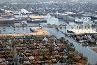
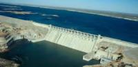
Restoring and sustaining Louisiana’s eroding coast
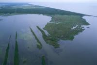
Measures taken over the last ninety years to prevent a repetition of the 1927 New Orleans flood — the construction of improved levees, spillways, and dams as well as associated flood and additional navigation management structures designed to contain overflows and manage and stabilize a deep-water channel – have starved adjacent wetlands of the freshwater and sediment needed to stave off the Gulf of Mexico’s rising tides. The resulting land loss across the Delta is leading toward catastrophic collapse. Over the last century, almost 1,900 square miles of deltaic wetlands, an area approximately the size of Delaware, have disappeared from Louisiana. Every hour, a football field-sized swath of land drowns in the Gulf’s advancing tides. A Louisiana independent initiative, with the support and participation of the State of Louisiana and U.S. Army Corps of Engineers, has called on experts from the private sector to develop and assess new designs for the Lower Mississippi River (below New Orleans). The winning proposals were announced last week.
-
-
Coastal uplift along Pacific Coast lower than expected, exacerbating sea-level rise impact
A new study shows that uplift rates across the Pacific Coast of the United States and northern Mexico have been overestimated by an average of more than 40 percent. These lower uplift rates this may have important implications for coastal management, including earthquake hazards and the potential impact of sea-level rise to coastlines across the Pacific Coast. If the Pacific Coast’s uplift rate is lower than had been estimated, this means that sea-level rise would have an even greater impact on coastal communities and infrastructure. Higher coastal uplift rates would have negated some of the effects of rising sea levels, something lower uplift rate will not do.
-
-
Draft guide to help energy companies reduce cyber risk

DHS reported that 5 percent of the cybersecurity incidents its Industrial Control Systems Cyber Emergency Response Team responded to in fiscal year 2014 were tied to weak authentication. Four percent were tied to abuse of access authority. The National Cybersecurity Center of Excellence (NCCoE) is requesting comments on a draft guide to help energy companies better control who has access to their networked resources, including buildings, equipment, information technology, and industrial control systems.
-
-
Post-Katrina flood damage resulted from Corps of Engineers' errors, was preventable
A decade after hurricane Katrina hit New Orleans, experts say the flooding that caused over 1,800 deaths and billions of dollars in property damage could have been prevented had the U.S. Army Corps of Engineers retained an external review board to double-check its flood-wall designs. Researchers contend that the main fault in the failure of the flood walls along the city’s principal drainage canals was the misinterpretation of a full-scale load test carried out by the Corps in the Atachafalaya Basin a few years prior to Katrina. After these so-called E-99 tests, it was determined that flood walls in the city should be installed at a depth of 17 feet, instead of the initially estimated depths of 31 to 46 feet.
-
-
U.S. coastal communities face increasing risk of compound floods
In 2010, 39 percent of the U.S. population lived in coastal communities — a number which is expected to continue to increase in the next five years. The confluence of storm surges and heavy precipitation can bring dangerous flooding to low-lying coastal regions, including major metropolitan areas. A new study of the United States coastline has found the risk of such flooding is higher on the Atlantic coast than the Pacific, and the number of these compound events has increased significantly in many major cities in the past century.
-
-
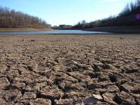
California levees face risk of catastrophic failure as a result of historic drought
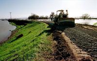
Earthen levees protect dry land from floods and function as water storage and management systems. Over 21,000 kilometers of earthen levees deliver approximately two-thirds of potable water to more than twenty-three million Californians and protect more than $47 billion worth of homes and businesses from flooding. Scientists say that the ongoing extreme drought in the state poses a risk of catastrophic failure to California’s levee systems and highlights an urgent need to invest in research regarding the vulnerabilities of these systems under extreme climatic events.
-
-
Climate change and Hurricane Katrina: what have we learned?
Theory and computer models show that the incidence of the strongest hurricanes — those that come closest to achieving their potential intensity — will increase as the climate warms, and there is some indication that this is happening. Global warming, however, is occurring far too fast for effective human adaptation. Adapting to the myriad changes expected over the next 100 years is such a daunting prospect that otherwise intelligent people rebel against the idea even to the extent of denying the very existence of the risk. This recalcitrance, coupled with rising sea levels, subsiding land, and increased incidence of strong hurricanes, all but guarantees that New Orleans will have moved or have been abandoned by the next century.
-
-
Interactive tool roots discussions about the cost of nuclear energy in hard evidence
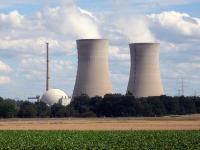
Despite the ever-changing landscape of energy economics, subject to the influence of new technologies and geopolitics, a new tool promises to root discussions about the cost of nuclear energy in hard evidence rather than speculation. Over the last two years, the Bulletin of the Atomic Scientists has developed the Nuclear Fuel Cycle Cost Calculator, an online interface that provides a nuanced look at the economic costs of nuclear power. The calculator provides a simple gateway into the physics-laden universe of nuclear economics. A user can slide more than sixty moving scales to tweak inputs like uranium price or reactor construction time, and then watch the expected price shift.
-
-
Civil engineering graduate students awarded scholarships for water research
Three Texas A&M graduate engineering students were recently awarded scholarships to pursue water-related research. The first project will investigate and better define “green water,” which is generally perceived as the soil water available for plants to use, and its potential to alleviate the projected water shortage for Texas agriculture. The second project focuses on future water availability and allocations in the Rio Grande River. The third focuses on the joint effects of climate change, urbanization and flow regulation on water supply in a metropolitan area.
-
-
Drought causing California’s San Joaquin Valley land to sink, damaging infrastructure
Californians continue pumping groundwater in response to the historic drought, and as a result, land in the San Joaquin Valley is sinking faster than ever before, nearly two inches per month in some locations. Sinking land, known as subsidence, has been occurring for decades in California because of excessive groundwater pumping during drought conditions, but the sinking is happening faster. The increased subsidence rates can damage local, state, and federal infrastructure, including aqueducts, bridges, roads, and flood control structures. Long-term subsidence has already destroyed thousands of public and private groundwater well casings in the San Joaquin Valley. Over time, subsidence can permanently reduce the underground aquifer’s water storage capacity.
-
-
New facility will be center of research to make U.S. grid more robust, smarter
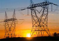
The U.S. electric power grid is the most complex machine ever built. Transforming it from an early twentieth century machine to a twenty-first century engine for innovation is a demanding scientific and technical challenge. The Pacific Northwest National Laboratory has launched its new Systems Engineering Building (SEB), in which industry, academia, and leading scientists will conduct research which will change the future of the U.S. power grid. “The private sector and the government must work together to ensure that we can prevent and recover from grid disruptions, whether they come from cyberattack, physical attack, or severe weather that is brought on by climate change,” Deputy Energy Secretary Elizabeth Sherwood-Randall said at the building’s dedication.
-
The long view
Helping Strengthen America’s Critical Infrastructure
Everyday life depends on a robust infrastructure network that provides access to running water, communications technology and electricity, among other basic necessities. The experts who keep our national infrastructure secure and resilient also need a strong network to share their knowledge and train the next generation of professionals capable of solving complex infrastructure challenges.
AI and the Future of the U.S. Electric Grid
Despite its age, the U.S. electric grid remains one of the great workhorses of modern life. Whether it can maintain that performance over the next few years may determine how well the U.S. competes in an AI-driven world.
Using Liquid Air for Grid-Scale Energy Storage
New research finds liquid air energy storage could be the lowest-cost option for ensuring a continuous power supply on a future grid dominated by carbon-free but intermittent sources of electricity.
Enhanced Geothermal Systems: A Promising Source of Round-the-Clock Energy
With its capacity to provide 24/7 power, many are warming up to the prospect of geothermal energy. Scientists are currently working to advance human-made reservoirs in Earth’s deep subsurface to stimulate the activity that exists within natural geothermal systems.
Experts Discuss Geothermal Potential
Geothermal energy harnesses the heat from within Earth—the term comes from the Greek words geo (earth) and therme (heat). It is an energy source that has the potential to power all our energy needs for billions of years.