-
Texas earthquake may have been manmade, but more data needed to assess hazards
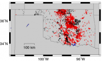
The most comprehensive analysis to date of a series of earthquakes that included a 4.8 magnitude event in East Texas in 2012 has found it plausible that the earthquakes were caused by wastewater injection. The findings also underscore the difficulty of conclusively tying specific earthquakes to human activity using currently available subsurface data.
-
-
Three years on, the Chelyabinsk superbolide mystery continues
On 15 February 2013, the approach of asteroid (367943) Duende to our planet was being closely monitored by both the public and the scientific community worldwide when suddenly a superbolide entered the atmosphere above the region of Chelyabinsk in Russia. Three years and hundreds of published scientific studies later, we are still looking for the origin of such unexpected visitor, which caused damage to hundreds of buildings and injuries to nearly 1,500 people.
-
-
Underestimate global warming by exaggerating cloud “brightening”
As the atmosphere warms, clouds become increasingly composed of liquid rather than ice, making them brighter. Because liquid clouds reflect more sunlight back to space than ice clouds, this “cloud phase feedback” acts as a brake on global warming in climate models. Researchers at Lawrence Livermore National Laboratory and Yale University have found, however, that climate models are aggressively making clouds “brighter” as the planet warms. This may be causing models to underestimate how much global warming will occur due to increasing carbon dioxide.
-
-
New urgency in preparing for solar storm Big One

The specter of a geomagnetic solar storm with the ferocity to disrupt communications satellites, knock out GPS systems, shut down air travel and quench lights, computers and telephones in millions of homes for days, months, or even years has yet to grip the public as a panic-inducing possibility. But it is a scenario that space scientists, global insurance corporations and government agencies from the Department of Homeland Security (DHS) to NASA to the White House Office of Science and Technology Policy (OSTP) take seriously, calling it a “low probability but high-impact event” that merits a substantial push on several fronts: research, forecasting, and mitigation strategy.
-
-
Historic preservation often neglected in disaster plans
Many communities fail to take historic preservation into account when planning for natural disasters, risking a loss of heritage and critical engines of the local economy in the event of catastrophe. Thousands of historic sites are left exposed to risk from floods and storms. “A lot of cultural and historic resources worldwide are at risk when natural hazards strike,” said the author of a recent study. “And even though we know this, very few resources are dedicated to protecting them.”
-
-
Soil’s carbon storage could help limit impact of climate change
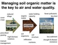
Soils currently lock away around 2.4 trillion tons of greenhouse gases, which are stored underground as stable organic matter. Researchers say the world’s soils could store an extra eight billion tons of greenhouse gases, helping to limit the impacts of climate change. Growing crops with deeper root systems, using charcoal-based composts, and applying sustainable agriculture practices could help soils retain the equivalent of around four-fifths of annual emissions released by the burning of fossils fuels, the researchers say.
-
-
Water cycle instability posing major political and economic risks: UN experts
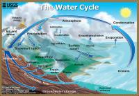
The current instability and unpredictability of the world water cycle is here to stay, making society’s adaptation to new risks a vital necessity when formulating development policies, a UN water expert warns. “What we haven’t understood until now is the extent to which the fundamental stability of our political structures and global economy are predicated on relative stability and predictability of the water cycle — that is, how much water becomes available in what part of the year. As a result of these new water-climate patterns, political stability and the stability of economies in most regions of the world are now at risk,” the expert says.
-
-
Renewables and nuclear no substitute for carbon dioxide disposal
Oxford scientist argues that there are only two things we can affect with policies today that will really matter for peak warming: reducing the cost of large-scale capture and disposal of carbon dioxide, and maximizing the average rate of economic growth we achieve for a given rate of emission in the meantime.
-
-
Flooding, accelerated sea-level rise in Miami over last decade
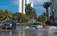
Miami Beach flood events have significantly increased over the last decade due to an acceleration of sea-level rise in South Florida. Scientists suggest that regional sea-level projections should be used in place of global projections to better prepare for future flood hazards in the region.
-
-
Global warming of 2.5°C degrees would put at risk trillions of dollars of world’s financial assets
An average of $2.5 trillion, or 1.8 percent, of the world’s financial assets would be at risk from the impacts of climate change if global mean surface temperature rises by 2.5°C (4.5°F) above its pre-industrial level by 2100, according to a new study. that the authors found, however, that uncertainties in estimating the “climate Value at Risk” mean that there is a 1 percent chance that warming of 2.5°C could threaten $24 trillion, or 16.9 percent, of global financial assets in 2100.
-
-
California drought patterns becoming more common
Atmospheric patterns resembling those that appeared during the latter half of California’s ongoing multi-year drought are becoming more common. The current record-breaking drought in California has arisen from both extremely low precipitation and extremely warm temperature. The new study found clear evidence that atmospheric patterns that look like those seen during this extreme drought have in fact become more common in recent decades.
-
-
Analyzing the effects of rising sea levels in Norfolk, Va.
In Norfolk, Virginia, an East Coast city which is home to the world’s largest naval station and important seaports, catastrophic flooding could damage more than homes and roads. A new study from Sandia National Laboratories assesses how much the city, its region, and the nation would suffer in damages to national assets and lost economic activity if it does nothing to address rising sea levels. The analysis method is available to cities that want to become more resilient.
-
-
Rapid Antarctica ice melt: Sea-level rise nearly double over earlier estimates
A new study suggests that the most recent estimates by the Intergovernmental Panel on Climate Change for future sea-level rise over the next 100 years could be too low by almost a factor of two. The researchers incorporated into their models mechanisms that were previously known but never incorporated in a model like this before, and added them to their ice-sheet model, so they could consider the effects of surface melt water on the break-up of Antarctica’s ice shelves and the collapse of vertical ice cliffs.
-
-
Starvation is only one crop breeding cycle away
Global population growth, urbanization, and a changing climate mean staple food crops will need to achieve much higher yields in the near future. New research proposes genetic engineering solutions to improve photosynthetic efficiency of food crops, boosting yield under higher temperatures and carbon dioxide levels. Because it can take twenty to thirty years of breeding and product development efforts before new crops are available to farmers, those efforts must start now.
-
-
Laser cloaking device to help us hide Earth from aliens
Several prominent scientists, including Stephen Hawking, have cautioned against humanity broadcasting our presence to intelligent life on other planets. Two astronomers suggest humanity could use lasers to conceal the Earth from searches by advanced extraterrestrial civilizations.
-
The long view
The Surprising Reasons Floods and Other Disasters Are Deadlier at Night
It’s not just that it’s dark and people are asleep. Urban sprawl, confirmation bias, and other factors can play a role.
Why Flash Flood Warnings Will Continue to Go Unheeded
Experts say local education and community support are key to conveying risk.