-
Climate-exodus expected as temperatures rise in Middle East, North Africa
More than 500 million people live in the Middle East and North Africa — a region which is very hot in summer and where climate change is already evident. The temperature during summer in the already very hot Middle East and North Africa will increase more than two times faster compared to the average global warming. This means that during hot days temperatures south of the Mediterranean will reach around 46 degrees Celsius (approximately 114 degrees Fahrenheit) by mid-century. As a result, the number of climate refugees could increase dramatically in future.
-
-
Chile quake information expands disaster and failure data repository
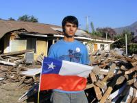
27 February 2010, is a date that most Chileans will probably never forget. On that day, the sixth strongest earthquake in recorded history — packing a force greater than the most powerful thermonuclear device ever tested — occurred off the country’s central coast. Now, thanks to a newly available set of data collected in the aftermath of the disaster, NIST is providing Chile and other quake-prone areas worldwide with a powerful tool toward becoming more resilient to future seismic events.
-
-
A rising tide of migration
“With sea levels on the rise, several island nations are scrambling to stay above water and ensure citizens will have a place to go when the ocean engulfs their homeland. The humanitarian-crisis phase of climate change has officially begun” – these are the opening sentences of an article just published in the Columbia Law School Magazine.
-
-
Human activity a major factor driving wildfires
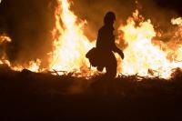
A new study that examines California wildfires found that human activity — such as tossing a lit cigarette along a highway — explains as much about the fires’ frequency and locations as climate influences. The researchers systematically looked at human behaviors and climate change together, a type of review that rarely is attempted on an area of land the size of California.
-
-
Repairing earthquake-damaged bridge columns in days, not weeks
In just thirty seconds, a devastating earthquake like the ones that struck Japan and Ecuador can render a city helpless. With roadways split and bridges severely damaged, residents and emergency personnel could be prevented from moving around to rebuild. Normally, it takes weeks to repair the cracking or spalling of columns on just one bridge damaged in an earthquake. Researchers have developed a new process of fixing columns that takes as little as a few days.
-
-
Putting consistent value on experts' uncertainty on climate change models
Science can flourish when experts disagree, but in the governmental realm uncertainty can lead to inadequate policy and preparedness. When it comes to climate change, it can be OK for computational models to differ on what future sea levels will be. The same flexibility does not exist for determining the height of a seawall needed to protect people from devastating floods. For the first time in the climate field, researchers have combined two techniques long used in fields where uncertainty is coupled with a crucial need for accurate risk-assessment — such as nuclear energy — in order to bridge the gap between projections of Earth’s future climate and the need to prepare for it.
-
-
Rising seas put Vietnam in the “bull’s eye” of rising seas
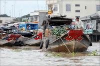
A rising sea level — for a country like Vietnam, with 2,000 miles of coastline — presents a major environmental and food security challenge, especially in the Mekong River Delta region where 22 percent of the population lives and about half of the country’s food is produced.
-
-
“G-Science” academies call for strengthening global disaster resilience

In the decade between 2005 and 2014, more than 6,000 natural and technological disasters occurred around the world, killing more than 0.8 million people, displacing millions more, and costing more than $1 trillion. Losses due to disasters are increasing in both developed and developing countries. Human factors that increase exposure and vulnerability, such as poverty, rapid population growth, disorderly urbanization, corruption, conflict and changes in land use, poor infrastructure including non-engineered housing, together with effects of climate change on weather patterns with increased extreme events, aggravate the negative consequences of natural and technological hazards.
-
-
New Web portal for coastal resilience
William & Mary Law School and William & Mary’s Virginia Institute of Marine Science (VIMS) are collaborating on a new Web site which will provide key information to support local, regional, and state efforts to adapt to sea-level rise. Tidal and storm surge flooding risks, FEMA flood zone maps, storm history, and critical infrastructure risk assessments are all topics that are likely to be included on the Web site. Information about conditions of shorelines, wetlands, beaches, and coastal forests will also be in the portal.
-
-
Changing climate in Michigan poses an emerging public health threat
Changing climate conditions — including warmer temperatures and an increased frequency of heavy rainstorms — represent “an emerging threat to public health in Michigan,” according to a new report from University of Michigan researchers and state health officials.
-
-
1.5°C vs 2°C global warming: Half a degree makes a big difference
European researchers have found substantially different climate change impacts for a global warming of 1.5°C and 2°C by 2100, the two temperature limits included in the Paris climate agreement. The additional 0.5°C would mean a 10-cm-higher global sea-level rise by 2100, longer heat waves, and would result in virtually all tropical coral reefs being at risk.
-
-
Citizen seismologists enhance the impacts of earthquake studies
From matchbook-sized sensors plugged into a desktop computer to location-tagged tweets, the earthquake data provided by “citizen seismologists” have grown in size and quality since 2000, according to the field’s researchers.
-
-
Globe continues to break heat records -- for 11th straight month
At the risk of sounding like a broken record, March set another heat record for the globe. As Earth continues to warm, and is influenced by phenomena such as El Niño, global temperature records are piling up. For 2016 year to date (January-March), the average temperature for the globe was 2.07 degrees F above the twentieth-century average. This was the highest temperature for this period in the 1880–2016 record.
-
-
How could we build an invisibility cloak to hide Earth from an alien civilization?
What would it take to hide an entire planet? It sounds more like a question posed in an episode of “Star Trek” than in academic discourse, but sometimes the bleeding edge of science blurs with themes found in science fiction. Of course we’ve been leaking our own position to distant stars via radio and television signals for six decades now, largely ignorant of the cosmic implications. But several notable scientists, such as Stephen Hawking, have publicly voiced concerns about revealing our presence to other civilizations. These concerns largely draw from the darker chapters of our own history, when a more advanced civilization would subjugate and displace a less advanced one.
-
-
Digital mapping project tracks the last moments of the victims of Japan’s 2011 tsunami
Digital archives track the evacuation patterns of 2011 Great East Japan Earthquake victims between the time the earthquake and tsunami struck. The Tokyo Metropolitan University researchers who created the digital archives say they will make use of the archive to analyze evacuation behaviors — encouraging people, for instance, to avoid overestimating evacuation sites and head to higher ground.
-
The long view
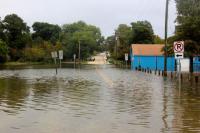
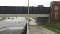
The Surprising Reasons Floods and Other Disasters Are Deadlier at Night
It’s not just that it’s dark and people are asleep. Urban sprawl, confirmation bias, and other factors can play a role.
Why Flash Flood Warnings Will Continue to Go Unheeded
Experts say local education and community support are key to conveying risk.