UAVsHelping UAVs to land safely in an emergency
One obstacle to the wider use of UAVs in domestic missions such as law enforcement is the fact that UAV flight plans are set pre-flight, and if something goes wrong and they need to land they have no way to determining where the safest landing spot is; in most cases they just drop; engineers are developing a system which will allow UAVs sense and avoid other traffic and determine appropriate landing spots should the need arise
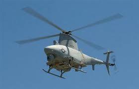
Engineers are working on a system that would allow a damaged UAV helicopter to determine the safest place to land // Source: baodatviet.vn
Queensland University of Technology (QUT) aviation researchers are developing an information system to help UAVs make safer emergency landings and better enable their wider commercial use.
A Queensland University of Technology release reports that aerospace engineering lecturer at the Australian Research Centre for Aerospace Automation (ARCAA), Dr. Luis Mejias Alvarez, said UAVs could not fly in commercial airspace over populated areas because they lacked the ability to sense and avoid other air traffic, and had no ability to make a safe landing in an emergency.
“UAV flight plans are set pre-flight, and if something goes wrong and they need to land they have no way to determining where the safest landing spot is,” he said. In most cases they just drop.
“We expect the system we’re developing will fit UAVs with a higher level of intelligence so that they can both sense and avoid other traffic and determine appropriate landing spots should the need arise. If we can do that we will have gone a long way towards enabling UAVs to fly in commercial airspace and enable their wider use.”
Mejias said the research would also be applicable to commercial aviation. He said during emergencies pilots focussed on regaining as much control of their aircraft as possible and there was a need for a system to help them choose appropriate landing sites.
“When things go wrong with an aircraft while it’s in flight a pilot has to try to manipulate a lot of instruments to gain control of their aircraft. The focus of their attention is on the instruments within the cockpit. It’s very difficult to also visually scout around the surrounding area to find the best possible places to land, particularly when the terrain below may be unfamiliar to the pilot.
“At QUT we’re working on a GPS-based system that will incorporate a camera to pinpoint to the pilot any larger, vacant spaces that would provide landing options. This might be a field or farm, or even a road or river. It will help the pilot navigate away from populated areas and find the safest landing spot.”