First-response gearBomb threat? There’s an app for that
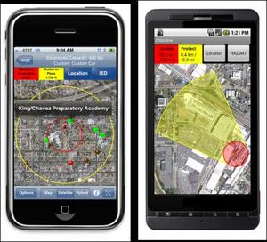
In the first chaotic moments after suspicion of a bomb threat, first responders have a myriad of questions, assessments, and decisions to make, all at once, and all the while the scene could be changing rapidly: Is the bomb real? How large is the potential blast radius? Where will we evacuate people? Are there any critical infrastructure or special-needs population centers in the vicinity? Any schools, hospitals nearby? What roads should be closed? Which roads should stay open for evacuees? There are many more questions, many more uncertainties; DHS Science and Technology Directorate (S&T) and its private sector partners have now developed a must-have app: the First Responder Support Tools (FiRST) for computers and smartphones
There is now an app for bomb threats // Source: eurekalert.org
At approximately 6:30 p.m. on Saturday, 1 May 2010, a smoking SUV in Times Square was reported by alert street vendors. Acting quickly, NYPD evacuated vast stretches on 7th and 8th Avenues, including Broadway theatres and several other buildings and hotels in the area. The entire area was barricaded. Times Square on a Saturday evening before the shows is teaming with people, and the terrorist knew that. The bomb failed, but had it detonated, it would have killed and wounded many, according to NYPD.
In the first chaotic moments after suspicion of a bomb threat, first responders have a myriad of questions, assessments, and decisions to make, all at once, and all the while the scene could be changing rapidly. Is the bomb real? How large is the potential blast radius? Where will we evacuate people? Are there any critical infrastructure or special-needs population centers in the vicinity? Any schools, hospitals nearby? What roads should be closed? Which roads should stay open for evacuees? There are many more questions, many more uncertainties.
What if they could get all this information in one place?
Now they can. DHS Science and Technology Directorate (S&T) says that it and its public and private sector partners have developed a must-have “app”: the First Responder Support Tools (FiRST) for computers and smartphones.
The FiRST application was developed in partnership with the DHS National Protection and Programs Directorate’s (NPPD) Office of Infrastructure Protection (IP) along with its Office for Bombing Prevention (OBP), and Applied Research Associates, Inc. (ARA). The FiRST app provides information directly to first responders on their smartphones or laptop computers in order quickly to define safe distances to cordon-off around a potential bomb location, calculate rough damage and injury contours, suggest appropriate roadblocks, determine when mandatory evacuation or shelter-in-place circumstances apply, and to identify nearby areas of particular concern: schools, hospitals, care centers. The application also provides the geospatial information regarding potential injury, glass, or structural damage impact area.
“That’s why it works,” said Christine Lee, FIRST program manager in S&T’s First Responder Group. “Bomb threat scenarios do not reflect a one-size-fits-all approach, and this app allows users to customize information to help them make informed decisions for response.”
The FiRST application also includes HAZMAT response information based on the Emergency Response Guidebook (ERG) which includes information on over 3,000 hazardous materials. In addition to providing health precautions and response guidance, FiRST also