DisastersEarthquake risk looms large in the Pacific Northwest
A comprehensive analysis of the Cascadia Subduction Zone off the Pacific Northwest coast confirms that the region has had numerous earthquakes over the past 10,000 years, and suggests that the southern Oregon coast may be most vulnerable based on recurrence frequency
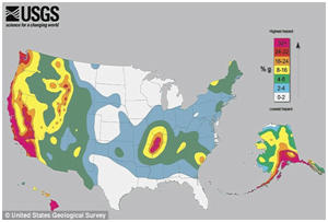
Map of U.S. earthquake risk // Source: google.com
A comprehensive analysis of the Cascadia Subduction Zone off the Pacific Northwest coast confirms that the region has had numerous earthquakes over the past 10,000 years, and suggests that the southern Oregon coast may be most vulnerable based on recurrence frequency.
Written by researchers at Oregon State University, and published online by the U.S. Geological Survey, the study concludes that there is a 40 percent chance of a major earthquake in the Coos Bay, Oregon, region during the next fifty years. That earthquake could approach the intensity of the Tohoku quake that devastated Japan in March of 2011.
“The southern margin of Cascadia has a much higher recurrence level for major earthquakes than the northern end and, frankly, it is overdue for a rupture,” said Chris Goldfinger, a professor in OSU’s College of Earth, Ocean, and Atmospheric Sciences and lead author of the study. “That doesn’t mean that an earthquake couldn’t strike first along the northern half, from Newport, Oregon, to Vancouver Island.
“But major earthquakes tend to strike more frequently along the southern end — every 240 years or so — and it has been longer than that since it last happened,” Goldfinger added. “The probability for an earthquake on the southern part of the fault is more than double that of the northern end.”
An Oregon State University release reports that the publication of the peer-reviewed analysis may do more than raise awareness of earthquake hazards and risks, experts say. The actuarial table and history of earthquake strength and frequency may eventually lead to an update in the state’s building codes.
“We are considering the work of Goldfinger, et al., in the update of the National Seismic Hazard Maps, which are the basis for seismic design provisions in building codes and other earthquake risk-mitigation measures,” said Art Frankel, who has dual appointments with the U.S. Geological Survey and the University of Washington.
The Goldfinger-led study took four years to complete and is based on thirteen years of research. At 184 pages, it is the most comprehensive overview ever written of the Cascadia Subduction Zone, a region off the Northwest coast where the Juan de Fuca tectonic plate is being subducted beneath the continent. Once thought to be a continuous fault line, Cascadia is now known to be at least partially segmented.
This segmentation is reflected in the region’s earthquake history, Goldfinger noted. “Over the past 10,000 years, there have been 19 earthquakes