HurricanesPredicting what could happen if Hurricane hits
A Sandia National Laboratories team is gearing up for hurricane season, readying analyses to help people in the eye of a storm. The team has two jobs: conducting annual “hurricane swath” analyses of probable impacts on the Gulf Coast and East Coast, and providing quick analyses of crisis response in the face of an imminent hurricane threat to the United States. A swath analysis looks at how a hurricane might interrupt critical services and at impacts to infrastructure specific to an area, such as petroleum and petrochemical industries in Houston or financial services in New York City. It also looks at such things as the economic impact of the storm or how it could upset food deliveries.
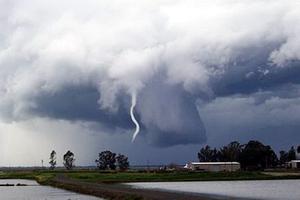
Impact of hurricanes difficult to predict // Source: presstv.ir
The Department of Homeland Security’s National Infrastructure Simulation and Analysis Center (NISAC), jointly housed at Sandia and Los Alamos national laboratories, studies how hurricanes and other disasters disrupt critical infrastructure such as roads, electricity, and water systems.
Hurricane season began 1 June and runs through 30 November. It generally peaks in August and September, notwithstanding Superstorm Sandy’s appearance late last October.
With the onset of hurricane season, NISAC has two jobs: conducting annual “hurricane swath” analyses of probable impacts on the Gulf Coast and East Coast and providing quick analyses of crisis response in the face of an imminent hurricane threat to the United States.
Analyses allow preliminary look at storm
A Sandia Lab release reports that a swath analysis looks at how a hurricane might interrupt critical services and at impacts to infrastructure specific to an area, such as petroleum and petrochemical industries in Houston or financial services in New York City. It also looks at such things as the economic impact of the storm or how it could upset food deliveries.
Federal officials pull swath analyses off the shelf when a hurricane seems likely to hit a particular place. They used the New Orleans report a few days before Hurricane Isaac headed toward that city last August.
“While it was too far out for us to do our analysis, they could use the report as a first cut,” said Dan Pless, NISAC program lead at Sandia.
NISAC’s portfolio includes a dozen swath analyses updated every few years, two cities at a time. A team coordinated by Mark Pepple, NISAC fast response lead, this year updated reports for Houston and Corpus Christi, Texas; last year the work focused on Miami and Tampa. Updates keep information from becoming too stale, Pless said.
NISAC came up with the original analyses, but is working on updates with state and local officials and Department of Homeland Security (DHS) agencies, including the Federal Emergency Management Agency (FEMA).
Reports analyze “reasonable bad scenario”
Each report uses a “reasonable bad scenario” that would be possible in the particular area, with local officials deciding what scenario would be most useful for disaster planning, said Pless and Pepple.
For example, a Category 5 hurricane isn’t likely in New York City because colder waters dampen hurricane strength, but a Category 3 is within reason.
“These storms form in the Caribbean, they form in the Gulf. They can get quite strong down there,” Pless said. “They don’t