Chemical weaponsSurvey of deep-sea chemical munitions dump off California finds no chemical weapons
Since the Second World War, U.S. nautical charts have shown seven “chemical munitions dumping areas” along the Pacific Coast between San Francisco and the Mexican border. Little or no information, however, is available about the amount, location, or nature of the materials that were dumped at most of these sites. Researchers from the Monterey Bay Aquarium Research Institute (MBARI) conducted a detailed survey of one supposed deep‐water dump site off Southern California, and found that it contained no chemical munitions. The researchers conclude that not all sites marked as chemical munitions dumps may actually have been used for this purpose.
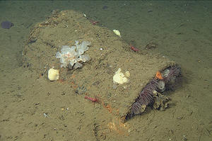
plecty of garbage, but no chemical weapons // Source: mbari.org
Since the Second World War, U.S. nautical charts have shown seven “chemical munitions dumping areas” along the Pacific Coast between San Francisco and the Mexican border. Little or no information, however, is available about the amount, location, or nature of the materials that were dumped at most of these sites. At last week’s annual meeting of the American Geophysical Union, researchers from the Monterey Bay Aquarium Research Institute (MBARI) describe a survey of one supposed deep‐water dump site off Southern California. The preliminary survey turned up trash and 55‐gallon drums, but no chemical munitions. In addition to suggesting that not all marked sites contain chemical munitions, this study demonstrates that underwater robots can be used to survey such sites to identify areas of concern.
An MBARI release reports that a total of thirty-two chemical munitions dumping areas are shown on nautical charts of United States waters. Seven of these lie off the California coast, between San Francisco and the Mexican border. Some of the marked areas off California are huge, encompassing almost 4,000 square kilometers of seafloor.
Of the seven California sites, only the area off San Francisco has been studied in any detail.
This concerns MBARI chemical oceanographer Peter Brewer. If chemical munitions were dumped at these sites, they could pose a hazard to fishers and researchers studying the seafloor. Over the last fifty years, hundreds of fishermen in Japan, the Baltic Sea, and off the east coast of the United States have been injured by chemical munitions caught in their nets. On the other hand, Brewer suspects that some of the marked sites off California may not contain munitions at all. Other sites might contain munitions, but the areas of affected seafloor are likely to be much smaller than the areas shown on the charts.
With this in mind, Brewer used two different types of underwater robots to perform a preliminary survey of a marked dump site in the Santa Cruz Basin, about 110 kilometers (70 miles) southwest of Los Angeles, in water about 1,900 meters (6,300 feet) deep.
In March 2013, MBARI’s seafloor‐mapping AUV (autonomous underwater vehicle) spent eighteen hours surveying a portion of the Santa Cruz Basin using side‐scan sonar. Following a preprogrammed zig‐zag path about twenty-five meters above the ocean bottom, the AUV surveyed almost twenty-six square kilometers of seafloor, including areas inside and outside the marked dump site. Within the surveyed areas, researchers counted 754 “targets” (objects sticking up from the seafloor).
Although the AUV sonar surveys allowed the researchers to locate hard objects on the seafloor, they did not provide enough detail so that these objects could be positively identified. To find out what was actually on the seafloor, Brewer’s team returned to the Santa Cruz Basin in May 2013 and videotaped the seafloor using one of MBARI’s remotely operated vehicles, the ROV Doc Ricketts.
AUV survey turned out to be garbage such as canned goods and cases of bottled water. The researchers also found two small, unarmed drones used by the military for target practice, and a 30‐meterlong steel mast from a ship. In short, the ROV survey turned up all sorts of marine debris, but no chemical weapons.
Based on the results of this partial survey, Brewer and his fellow researchers suggest that not all sites marked as chemical munitions dumps may actually have been used for this purpose. Their work demonstrates, however, that modern undersea robots, such as MBARI’s seafloor‐mapping AUV, are capable of surveying such marked dump areas relatively quickly. Such surveys will help cartographers redraw the lines around these areas, to more accurately reflect what’s on the seafloor.
— Read more in Peter G. Brewer et al., “High Resolution Mapping of an Alleged Chemical Weapons Dump Site in the Santa Cruz Basin, offshore California (a paper presented at the American Geophysical Union meeting, San Francisco, 11 December 2013)