Infrastructure protectionFlorida moves to protect coastal roads from sea level rise
Alton Road is a few blocks west of the Atlantic Ocean, and is Miami Beach’s lowest point, at 2.8 feet above sea level. Trouble is, as a result of sea level rise, inundation tide now routinely reaches 3.4 feet above sea level. Geologist have long warned of the impact sea level rise would have on Florida’s coastal infrastructure, and they view Alto Road as Ground Zero, saying that at some point in the near future, water from flooding will not recede. The Florida Department of Transportation (FDOT) is taking steps to protect coastal transportation infrastructure from sea level rise.
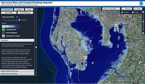
Light blue coastal area projected to be flooded at sea level rise // Source: epa.gov
The southern coast of Florida is vulnerable to the effects of sea level rise and sections of Alton Road in South Beach may be Ground Zero. Scientists believe that at some point in the near future water from flooding will not recede, so Florida transportation authorities are taking steps to reduce the effects of flooding. The Florida Department of Transportation (FDOT) has closed Alton Road to install three new pump stations, new inlets, and piping to improve drainage and alleviate flooding. FDOT is also trying to understand the level of impact sea level rise will have on roadways, bridges, airports, and railways in Florida.
According to the Miami Herald, a 2012 report for FDOT by Florida Atlantic University noted that major roads in the Dania Beach area, including Federal Highway A1A, Griffin Road, Stirling Road, and Sheridan Street, are “potentially vulnerable” to sea level rise.
“FDOT is supporting adaptation planning and long-term understanding of the impacts of sea level change through research,” said Brian Rick, an FDOT spokesman in Miami. FDOT, in coordination with the University of Florida’s GeoPlan Center, has developed an application to assess the effects of sea level change on roads. The technology uses Geographic Information System through which experts can obtain, store, analyze, and display vast amounts of geographic data.
Activists have been pressuring local and federal authorities to take proactive steps to protect Florida from the effects of sea level rise. In October 2012, at the corner of 10th Street and Alton Road, environmentalists waded into ankle-deep water to stage a rally informing the public that sea level rise is a present issue. Alton Road is a few blocks west of the Atlantic Ocean and is Miami Beach’s lowest point, at 2.8 feet above sea level. The inundation tide has reached 3.4 feet above sea level.
The new drainage system being installed by FDOT will push flood water away from the road during high tide events. “Season high tides were considered in the design, which resulted in the use of backflow preventers and pump stations,” said Rick. FDOT’s $32 million Alton Road project is expected to be completed in August 2015. Inundations of Alton Road occur mostly in mid-October.