Coastal resilienceSea-level rise threatens many coastal U.S. military bases
The U.S. Armed Forces depend on safe and functional bases to protect the U.S. national security. Sea levels are rising as global warming heats up the planet, and many military bases along the U.S. East Coast and Gulf of Mexico are at risk of permanently losing land to the ocean in the decades ahead. As the seas rise, high tides will reach farther inland. Tidal flooding will become more frequent and extensive. When hurricanes strike, deeper and more extensive storm surge flooding will occur. The United States must thus prepare for the growing exposure of its military bases to sea level rise.
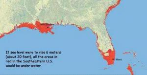
Map shows areas of Florida in jeopardy that hold eighteen military bases // Source: usf.edu
Sea levels are rising as global warming heats up the planet. Many military bases along the U.S. East Coast and Gulf of Mexico are at risk of permanently losing land to the ocean in the decades ahead.
As the seas rise, high tides will reach farther inland. Tidal flooding will become more frequent and extensive. When hurricanes strike, deeper and more extensive storm surge flooding will occur.
The Union of Concerned Scientists (UCS) notes that the U.S. Armed Forces depend on safe and functional bases to protect the U.S. national security. The United States must thus prepare for the growing exposure of its military bases to sea level rise.
Military bases at risk
Eighteen military installations are included in the UCS analysis. Each location’s changing exposure to flooding is projected through the end of the century:
- Maine:Portsmouth Naval Shipyard
- New Jersey:U.S. Coast Guard Station Sandy Hook
- Maryland:U.S. Naval Academy
- Washington, DC:Joint Base Anacostia-Bolling and Washington Navy Yard
- Virginia:Joint Base Langley-Eustis|Naval Air Station Oceana Dam Neck Annex| Naval Station Norfolk
- North Carolina:Marine Corps Base Camp Lejeune
- South Carolina:Marine Corps Recruit Depot Parris Island and Marine Corps Air Station Beaufort
- Georgia:Hunter Army Airfield | Naval Submarine Base Kings Bay
- Florida:Naval Air Station Key West| Naval Station Mayport| Eglin Air Force Base
Key findings
UCS says that the military is at risk of losing land where vital infrastructure, training and testing grounds, and housing for thousands of its personnel currently exist.
- By 2050, most of the installations in this analysis will see more than ten times the number of floods they experience today.
- By 2070, half of the sites could experience 520 or more flood events annually — the equivalent of more than one flood daily.
- By 2100, eight bases are at risk of losing 25 percent to 50 percent or more of their land to rising seas.
- Four installations — Naval Air Station Key West, Joint Base Langley-Eustis, Dam Neck Annex, and Parris Island — are at risk of losing between 75 and 95 percent of their land by the end of this century.
- Flooding will not be confined to the bases. Many surrounding communities will also face growing exposure to rising seas.
Planning for rising seas
The gap between the military’s current preparedness for sea level rise and the threats outlined in the report is large and growing.
UCS says that to plan effectively for the long term, military decision makers with authority over these bases need to understand how sea level rise may permanently alter the landscape and where the threat of storm surge may become intolerable.
To take action, however, individual installations will need more detailed analysis and resources to implement solutions.
Congress and the Department of Defense should, for example:
- Support the development and distribution of high-resolution hurricane and coastal flooding models
- Adequately fund data monitoring systems such as our nation’s tide gauge network
- Allocate human, financial, and data resources to detailed mapping and planning efforts at military installations.
- As adaptive measures are identified, allocate resources for these projects, many of which will stretch over decades.
The U.S.“defense leadership has a special responsibility to protect the sites that hundreds of thousands of Americans depend on for their livelihoods and millions depend on for national security,” UCS concludes.
— Read more in The U.S. Military on the Front Lines of Rising Seas: Growing Exposure to Coastal Flooding at East and Gulf Coast Military Bases (UCS, July 2016)