Nuclear mattersFive U.S. nuclear plants in earthquake zones
Five active U.S. nuclear reactors — the Diablo Canyon Power Plant and San Onofre Nuclear Generating Station in California; the South Texas Project near the Gulf Coast; the Waterford Steam Electric Station in Louisiana; and the Brunswick Steam Electric Plant in North Carolina — are situated in seismic activity-prone zones
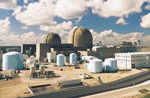
The South Texas Project nuclear plant // Source: nuclearstreet.com
Five active U.S. nuclear reactors – the Diablo Canyon Power Plant and San Onofre Nuclear Generating Station in California; the South Texas Project near the Gulf Coast; the Waterford Steam Electric Station in Louisiana; and the Brunswick Steam Electric Plant in North Carolina – are situated in seismic activity-prone zones.
They appear in an analysis by the Redlands, California-based mapping and geographic data firm ESRI Inc. The online map, the first of its kind to let the public search potential danger zones by address, includes U.S. Geologic Survey (USGS) seismic information and earthquake history for every nuclear plant in the United States.
USA Today quotes Victor Dricks, a Nuclear Regulatory Commission (NRC) spokesman, to say that NRC regulations require companies that build nuclear plants to take into account local seismic history and fortify the plants against the largest quake that is likely to occur.
He pointed out, for instance, that San Onofre is built to withstand a magnitude-7.0 earthquake within 5 miles of the site. In addition, the plant is thirty feet above sea level and has a reinforced concrete sea wall which is thirty feet tall and could withstand a 27-foot tsunami.
The ESRI interactive map would helps Americans find how close they live to an active nuclear reactor, whether they live within 10-mile or 50-mile U.S. evacuation zones of any nuclear plants, and whether the plant is located in an earthquake zones experiencing magnitude-7.2 or higher tremor in the past thirty years.
“All of the earthquakes on this map are significant,” said ESRI analyst Bronwyn Agrios, noting that the analysis was eye-opening for those on ESRI’s staff. “We found that we’re just on the cusp of the evacuation zone of the San Onofre plant, just down the coast on the ocean side. Right around our area there have been three earthquakes. We’re in a highly dense area for faults. We can feel that. We can feel tremors every week.”
William Leith, acting associate director for natural hazards at the USGS, said that although most nuclear plants are in the central and eastern United States, where earthquakes are rare, the USGS ranks thirty-nine states as having a high or moderate earthquake risk. USA Today notes that new studies have shown that at least twenty magnitude-9.0 earthquakes have struck off the coast of Northern California, Oregon, and Washington in the past 20,000 years, most recently in 1700, he said.