DisastersScientists detonate underground bombs in California for earthquake research
To study California’s fault lines, researchers recently detonated explosives underground to create 3D models of seismic activity; a team of geologists and seismic experts travelled to areas in the Imperial and Coachella Valley, roughly 150 miles northeast of San Diego, California, to study the southern tip of the San Andreas Fault; a team detonated more than 120 explosives more than sixty feet deep to set off seismic waves; the team measured these wave patterns with 3,000 different sensors to create a 3D map in these fault areas; their work comes as part of the Salton Seismic Imaging Project
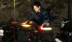
Preparing to detonate explosives // Source: statesman.com
To study California’s fault lines, researchers recently detonated explosives underground to create 3D models of seismic activity.
A team of geologists and seismic experts travelled to areas in the Imperial and Coachella Valley, roughly 150 miles northeast of San Diego, California, to study the southern tip of the San Andreas Fault.
Geologists believe that it is only a matter of time before a large quake strikes along the fault. When it does strike, geologist Pat Abbot, said, “I would expect significant damage within the city limits of San Diego.”
According to a 2008 study by the U.S. Geological Survey (USGS), there is nearly a 50 percent chance that an earthquake of a magnitude 7.5 or higher will strike California within the next thirty years. The quake is projected to most likely occur in southern California.
Gary Fuis, a geophysicist with USGS, said, “We’re pretty worried about [the earthquake],” which is why he led a team of researchers to study the fault lines.
He and his team detonated more than 120 explosives more than sixty feet deep to set off seismic waves. His team measured these wave patterns with 3,000 different sensors to create a 3D map in these fault areas.
Experts said that the explosions were not large enough to set off an earthquake along the fault line.
Their work comes as part of the Salton Seismic Imaging Project, which is helping to provide researchers with a detailed view of the San Andreas Fault and other fault lines in Southern California.
Joann Stock, a professor of geology and geophysics at Caltech and a member of the Salton Seismic Imaging Project, explained, “It will help us better understand how bad it’s going to shake down there when there’s a big earthquake.”
Researchers will now have to analyze the data gathered from the explosive tests and expect to release their findings in September.
The results of the study could potentially have a major impact on local building standards as well as emergency response plans.
The 3D mapping project is funded by a $1.2 million grant from the National Science Foundation in addition to money from the USGS.