-
Quake-detection app recorded nearly 400 temblors worldwide
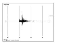
UC Berkeley’s worldwide network of smartphone earthquake detectors has recorded nearly 400 earthquakes since the MyShake app was made available for download in February, with one of the most active areas of the world the fracking fields of Oklahoma. The Android app harnesses a smartphone’s motion detectors to measure earthquake ground motion, then sends that data back to the Berkeley Seismological Laboratory for analysis. The eventual goal is to send early-warning alerts to users a bit farther from ground zero, giving them seconds to a minute of warning that the ground will start shaking.
-
-
The origins of Tennessee’s recent wildfires
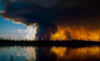
Wildfires raged recently through the foothills of Tennessee’s Great Smoky Mountains, fueled by severe drought and high winds in the eastern part of the state. The fires damaged or destroyed more than 1,400 structures, including homes, chapels, and resort cabins. Fourteen people were killed, and nearly 150 others were injured. Last week, two juveniles were taken into custody and charged with aggravated arson in connection with the deadly wildfires – but sources such as Climate Central suggested that rising temperatures may have played a role in the fires. Does climate change play a role in determining the frequency and intensity of wildfires?
-
-
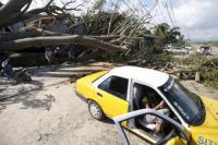
New approach calculates benefits of building hazard-resistant structures
The southeastern United States was hit hard by weather patterns resulting from Hurricane Matthew in October. Georgia has sustained some $90 million in insured losses to date, and total claims are expected to rise. Florida was spared Matthew’s worst effects, but the state is regularly witness to the destructive power of such storms and there’s a lot at stake: The insured value of residential and commercial properties in Florida’s coastal counties now exceeds $13 trillion. Calculation developed by MIT Concrete Sustainability Hub shows that when building in areas prone to natural disasters, it pays to make informed decisions.
-
-
Improving methods to assess earthquake-caused soil liquefaction
Several strong earthquakes around the world have resulted in a phenomenon called soil liquefaction, the seismic generation of excess porewater pressures and softening of granular soils, often to the point that they may not be able to support the foundations of buildings and other infrastructure. Effectively engineering infrastructure to protect life and to mitigate the economic, environmental, and social impacts of liquefaction requires the ability to accurately assess the likelihood of liquefaction and its consequences.
-
-
Dust Bowl would devastate today’s crops: Study

A drought on the scale of the legendary Dust Bowl crisis of the 1930s would have similarly destructive effects on U.S. agriculture today, despite technological and agricultural advances, a new study finds. Additionally, warming temperatures could lead to crop losses at the scale of the Dust Bowl, even in normal precipitation years by the mid-twenty first century.
-
-
May 2012 North Korean seismic event an earthquake, not nuclear test
A tiny seismic event that occurred in North Korea on 12 May 2010 appears to have been an earthquake rather than a small underground nuclear explosion, according to a new analysis. The new study contradicts the findings of a 2015 report which concluded that the magnitude 1.5 seismic 12 May event was a small nuclear explosion.
-
-
Freezing in record lows may raise doubts about global warming
If you are shivering from unusually teeth-rattling cold this holiday season, global warming is probably the last thing on your mind. “The local weather conditions people experience likely play a role in what they think about the broader climate,” says one expert. “Climate change is causing record-breaking heat around the world, but the variability of the climate means that some places are still reaching record-breaking cold. If you’re living in a place where there’s been more record cold weather than record heat lately, you may doubt reports of climate change.”
-
-
Accelerating sea level rise requires collaborative response: Experts
Recent estimates suggest that global mean sea level rise could exceed two meters by 2100. The projections pose a challenge for scientists and policymakers alike, requiring far-reaching decisions about coastal policies to be made based on rapidly evolving projections with large, persistent uncertainties. Policymakers and scientists must thus act quickly and collaboratively to help coastal areas better prepare for rising sea levels globally, say climate change experts.
-
-
Most U.K. coastal flooding caused by moderate, not extreme storms
Scientists have found that the majority of instances of coastal flooding around the United Kingdom in the last 100 years have been due to moderate storm events combined with high spring tides, rather than extreme storms.
-
-
Climate engineering uncertainties limit its use in slowing climate change
Climate engineering refers to the systematic, large-scale modification of the environment using various climate intervention techniques. A new suggests that the uncertainties associated with climate engineering are too great for it to provide an alternative to the rapid reduction of greenhouse gas emissions.
-
-
Remote-control skillful rescue robot demonstrated
Researchers have developed a prototype construction robot for disaster relief situations. This prototype has drastically improved operability and mobility compared to conventional construction machines.
-
-
Seeking greater accuracy in predicting storm strength
Fully developed tropical cyclones — variously called hurricanes, typhoons or cyclones, depending on their region — can grow as wide as several hundred miles and sustain winds faster than 150 miles per hour. For example, Typhoon Tip (1979) had 190-mph winds and Hurricane Patricia (2015) whipped up 215-mph winds (the record). Such storms are notoriously difficult to predict, presenting a volatile meteorological cocktail that can change direction, speed, and strength, quickly and unexpectedly.
-
-
Helping shape safer coastal communities
Higher dunes can help protect communities from damaging waves and surge; they can also impede natural coastal processes. Scientists need better to understand how dunes’ effectiveness in protecting developed areas will be affected by long-term coastal change, or by extreme events such as hurricanes. Coastal zone research projects will fill in some of those knowledge gaps, heling managers protect developed areas’ beach dunes, which are vital to resilient communities, ecosystems, and economies.
-
-
Accelerating sea level rise threatens communities, infrastructure in NY, NJ, Conn.
Parts of the New York, New Jersey, and Connecticut metropolitan area are at risk of being permanently flooded by sea level rise. A new study details the severe threats posed to the region’s bay areas, coastal urban centers, beach communities, and airports and seaports by as little as one foot of sea level rise, a possibility as soon as the 2030s. Sea level rise already has begun to affect communities and critical infrastructure in the region, and presents tough decisions for vulnerable areas.
-
-
U.K. winter 2015-16 floods: One of the century’s most extreme and severe flood episodes
A new scientific review of the winter floods of 2015-2016 confirms that the event was one of the most extreme and severe hydrological events of the last century. The new hydrological appraisal brings together both river flow and meteorological data in an analysis of the events that led to extensive river flooding in northern England, Scotland, Northern Ireland, and parts of Wales over a three-month period.
-
The long view
Using Drone Swarms to Fight Forest Fires
Forest fires are becoming increasingly catastrophic across the world, accelerated by climate change. Researchers are using multiple swarms of drones to tackle natural disasters like forest fires.
How Climate Change Will Affect Conflict and U.S. Military Operations
“People talk about climate change as a threat multiplier,” said Karen Sudkamp, an associate director of the Infrastructure, Immigration, and Security Operations Program within the RAND Homeland Security Research Division. “But at what point do we need to start talking about the threat multiplier actually becoming a significant threat all its own?”