-
Autumn 2015 was record warm for the contiguous U.S.

The National Oceanic and Atmospheric Administration (NOAA) ha release a report which shows that the autumn of 2015 was the warmest autumn in the last 121 years — since measurements began in 1895. The September-November contiguous U.S. average temperature was 56.8°F, 3.3°F above the twentieth century average, surpassing the previous record of 56.6°F set in 1963. Record and near-record warmth spanned much of the nation. The November contiguous U.S. temperature was 44.7°F, 3.0°F above the twentieth century average and the thirteenth warmest in the 121-year period of record.
-
-
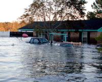
“Unprecedented” storms, floods in north-west England are more common than we think

The recent “unprecedented” flooding in north-west England might be more common than currently believed, a group of scientists has warned. A team of experts has drawn on historic records to build a clearer picture of the flooding. They conclude that twenty-first-century flood events such as Storm Desmond are not exceptional or unprecedented in terms of their frequency or magnitude, and that flood frequency and flood risk forecasts would be improved by including data from flood deposits dating back hundreds of years.
-
-
Better FEMA options for increasing the affordability of flood insurance
FEMA currently does not have the policy analysis capacity or necessary data to comprehensively analyze different options for making flood insurance more affordable. A new report identifies an approach for the Federal Emergency Management Agency (FEMA) to evaluate policy options for making premiums through the National Flood Insurance Program (NFIP) more affordable for those who have limited ability to pay.
-
-
Terror attacks in Paris and California expose modern society’s lack of resilience
Our complex global society lacks resilience. The root cause of our vulnerability is the structure of the global economy: highly interconnected, complex, and filled with turbulence. Major disasters can occur unexpectedly, and even minor incidents can cascade into significant human and financial losses. Emerging pressures such as climate change and urbanization will only intensify the potential for extreme events and severe disruptions. Risk management makes sense in a stable environment with predictable events, but in today’s more complex risk landscape — the new normal — it is inadequate for dealing with fast-moving, unfamiliar threats that may cascade into disasters. The good news is that brittleness is not inevitable. It is a fundamental design flaw. Resilience — the capacity to survive, adapt, and flourish in the face of disruptive change — is a basic characteristic of all living systems, from individual creatures to entire ecosystems. In this age of turbulence, resilience has become a prerequisite for continued prosperity.
-
-
Human skin detection technology improves security, search and rescue
Color-image based systems are excellent at locating people in aerial search and rescue operations, but fall short when it comes to discerning between actual human skin and objects with similar hues. To remedy this, researchers have developed a novel two-dimensional feature space which uses the spectral absorption characteristics of melanin, hemoglobin and water to better characterize human skin.
-
-
Climate outlook may be worse than feared
The impact of climate change may be worse than previously thought, a new study suggests. The research first created a simple algorithm to determine the key factors shaping climate change and then estimated their likely impact on the world’s land and ocean temperatures. The method is more direct and straightforward than that used by the IPCC, which uses sophisticated, but more opaque, computer models.
-
-
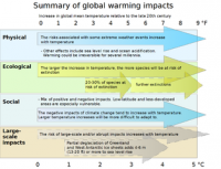
Climate change impacts may appear in some areas sooner than expected
Some impacts of global climate change will appear much sooner than others — with only moderate increases in global temperature. While rising sea levels may one day threaten the commuter tunnels and subway lines of New York City, it will have effects much sooner in other parts of the world – for example, the Marshall Islands and Bangladesh. In countries exposed to the destructive effects of climate change sooner rather than later, there will be little incentives to do something about climate change because the damage has already been done. Thus, once significant portions of the Marshall Islands or Bangladesh are destroyed by rising seas, the rate of damage will reach “saturation” — an inflection point beyond which further temperature increases have little additional effect. Once the Marshall Islands are large sections of Bangladesh are uninhabitable, there is not more damage that can be done there, and the governments of these countries will not have an incentive to participate in global climate efforts because they will not have anything more to lose.
-
-
Global freshwater loss due to dams, irrigation much larger than previously thought
Dams and irrigation, by increasing evapotranspiration, raise the global human consumption of freshwater to a much higher level than previously thought. This effect increases the loss of freshwater to the atmosphere and thereby reduces the water available for humans, societies and ecosystems on land.
-
-
First code improvements based on NIST Joplin tornado study adopted
Protecting schools and their associated high-occupancy buildings from the most violent tornadoes is the goal of the first approved building code changes based on recommendations from the National Institute of Standards and Technology (NIST) technical investigation into the impacts of the deadly tornado that struck Joplin, Missouri, on 22 May 2011. The new changes, approved at a recent meeting of the International Code Council (ICC), apply to the nation’s most tornado-prone regions.
-
-
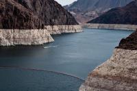
U.S. worsening droughts require alternative ways of protecting urban water supplies
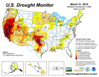
In the American West, unprecedented droughts have caused extreme water shortages. The current drought in California and across the West is entering its fourth year, with precipitation and water storage reaching record low levels. Droughts are ranked second in the United States in terms of national weather-related economic impacts, with annual losses just shy of $9 billion. With water scarcity likely to increase due to advancing climate change, the economic and environmental impacts of drought are also likely to get worse. Alternative models of watershed protection that balance recreational use and land conservation must no longer be ignored to preserve water supplies against the effects of climate change, experts argue.
-
-
Global warming may affect oxygen-producing ocean phytoplankton
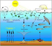
Past and current climate change has affected the food sources in the surface waters in the North Pacific Ocean. Climate change is predicted to alter marine phytoplankton (algae and diatoms) communities and affect productivity, biogeochemistry, and the efficacy of the biological pump. The slow global warming over the most recent approximate 150 years – roughly corresponding to the industrial revolution — has been beneficial, seeing an increase in nitrogen fixing cyanobacteria resulting in food production. “It’s sort of a carbon credit because the phytoplankton are making their own nitrogen-based fertilizer out of dissolved nitrogen,” says one researcher. But if global warming continues, the consequences may be dire. “This picoplankton community shift may have provided a negative feedback to rising atmospheric carbon dioxide, during the last 100 years. However, we cannot expect this to be the case in the future,” the researcher said.
-
-
Depletion of ocean phytoplankton could suffocate life on planet Earth

About two-thirds of the planet’s total atmospheric oxygen is produced by ocean phytoplankton — and therefore cessation would result in the depletion of atmospheric oxygen on a global scale, which could threaten the mortality of animals and humans.
-
-
Coal plant plans could make it impossible to hold warming below 2°C
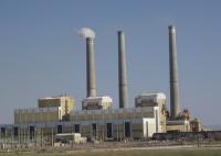
There are 2,440 planned coal plants around the world, totaling 1428GW, which could emit approximately 16-18 percent of the total allowed emissions in 2030 (under a 2°C-compatible scenario, medium range). If all coal plants in the pipeline were to be built, by 2030, emissions from coal power would be 400 percent higher than what is consistent with a 2°C pathway, according to a new analysis.
-
-
Climate change poses multiple threats to global food system
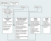
Climate change is likely to have far-reaching impacts on food security throughout the world, especially for the poor and those living in tropical regions, according to a new international report. The report warns that warmer temperatures and altered precipitation patterns can threaten food production, disrupt transportation systems, and degrade food safety, among other impacts. As a result, international progress in the past few decades toward improving food security will be difficult to maintain.
-
-
Social sciences are best hope for ending debates over climate change
The toxicity of the public debate in the United States over climate change is increasing, and to detoxify the debate, we need to understand the social forces at work. We must recognize that the public debate in the United States over climate change is not about carbon dioxide and greenhouse gas models; it is about opposing cultural values and worldviews through which that science is viewed. The opposing sides have less to do with the scientific basis of the issue and more to do with the ways in which people receive, assess, and act upon scientific information. To move forward, we have to disengage from fixed battle on one scientific front and seek approaches that engage people who are undecided about climate change on multiple social and cultural fronts. Only by broadening the scope of the debate to include this social and cultural complexity can we ever hope to achieve broad-scale social and political consensus. More scientific data can only take us so far; engaging the inherently human aspects of this debate will take us the rest of the way.
-
The long view
Risk Assessment with Machine Learning
Researchers utilize geological survey data and machine learning algorithms for accurately predicting liquefaction risk in earthquake-prone areas.