-
Rivers of meltwater on Greenland’s ice sheet contribute to rising sea levels
As the largest single chunk of melting snow and ice in the world, the massive ice sheet that covers about 80 percent of Greenland is recognized as the biggest potential contributor to rising sea levels due to glacial meltwater. Until now, however, scientists’ attention has mostly focused on the ice sheet’s aquamarine lakes — bodies of meltwater that tend to abruptly drain — and on monster chunks of ice that slide into the ocean to become icebergs. A new study reveals, however, a vast network of little-understood rivers and streams flowing on top of the ice sheet that could be responsible for at least as much, if not more, sea-level rise as the other two sources combined.
-
-
Which fossil fuels must remain in the ground to limit global warming?
A third of oil reserves, half of gas reserves, and over 80 percent of current coal reserves globally should remain in the ground and not be used before 2050 if global warming is to stay below the 2°C target agreed by policy makers, according to new research. The study also identifies the geographic location of existing reserves that should remain unused and so sets out the regions that stand to lose most from achieving the 2°C goal.
-
-
Geochemical reactions may limit effectiveness of carbon storage schemes
New research shows that the natural reactions taking place in some of the underground reservoirs used to store carbon dioxide may prevent carbon emissions from being transported to greater depths, where it may be less likely to leak into the atmosphere. Geochemical reactions taking place in aquifers — underground layers of water-bearing porous rock — may lead to carbon dioxide being “pooled” for hundreds or even thousands of years, and may force a rethink of how these underground reservoirs are used in carbon capture and storage (CCS) schemes.
-
-
Ten years after the Boxing Day tsunami, are coasts any safer?
Ten years ago we witnessed one of the worst natural disasters in history, when a huge earthquake off the coast of Sumatra triggered a devastating tsunami which swept across the Indian Ocean. An estimated 230,000 people lost their lives, and 1.6 million people lost their homes or livelihoods. The impact was greatest in northern Sumatra because of its proximity to the earthquake. Catastrophic shaking was followed within minutes by the full force of the tsunami. Thousands of people were also killed in distant countries, where the earthquake could not be felt. If they had received a warning of the approaching tsunami, they could have moved inland, uphill or out to sea, and survived. Future tsunami disasters are inevitable, but with better technology, education and governance we can realistically hope that a loss of life on the scale of the 2004 tsunami disaster will not happen again.
-
-
Helping coastal communities to visualize sea-level rise
As part of the Federal Emergency Management Agency’s (FEMA) initiative to encourage communities to become more aware of the effects of climate change, the agency has awarded Marin County, California a $150,000 grant to engage residents in climate change issues by allowing them to visualize the effects of sea level rise. The grant will pay for two sophisticated viewfinders programed to envision how the landscape will appear in projected sea level rise scenarios, as well as how the landscape appeared in the past.
-
-
It will take 11 trillion gallons to replenish California drought losses: NASA
Since 2011, the Sacramento and San Joaquin river basins decreased in volume by four trillion gallons of water each year (fifteen cubic kilometers). This is more water than California’s thirty-eight million residents use each year for domestic and municipal purposes. About two-thirds of the loss is due to depletion of groundwater beneath California’s Central Valley. It will take about eleven trillion gallons of water (forty-two cubic kilometers) — around 1.5 times the maximum volume of the largest U.S. reservoir — to recover from California’s continuing drought, according to a new analysis of NASA satellite data.
-
-
Better forecasts for rain-on-snow flooding
Many of the worst West Coast winter floods pack a double punch. Heavy rains and melting snow wash down the mountains together to breach river banks, wash out roads and flood buildings. These events are unpredictable and difficult to forecast. Yet they will become more common as the planet warms and more winter precipitation falls as rain rather than snow. Mountain hydrology experts are using the physics behind these events to better predict the risks.
-
-
Mecca faces severe air pollution during annual pilgrimage
Dangerously high levels of air pollutants are being released in Mecca during the hajj, the annual holy pilgrimage in which millions of Muslims on foot and in vehicles converge on the Saudi Arabian city, according to findings of a new study. “Hajj is like nothing else on the planet. You have 3 to 4 million people — a whole good-sized city — coming into an already existing city,” said one researcher. “The problem is that this intensifies the pollution that already exists. We measured among the highest concentrations our group has ever measured in urban areas — and we’ve studied seventy-five cities around the world in the past two decades.”
-
-
New chemical sponge would lessen the carbon footprint of oil industry
U.K. scientists have discovered a ground-breaking technique with the potential dramatically to reduce the amount of energy used in the refinement of crude oil. The existing industrial process uses huge amounts of energy to separate and purify these gases, so the new technique has the potential to revolutionize the oil industry by significantly reducing carbon emissions and making the process more environmentally friendly.
-
-
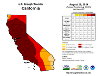
2012-14 California drought the worst in 1,200 years
New research shows that the California drought of 2012-14 has been the worst in 1,200 years. California is the world’s eighth largest economy and the source of a substantial amount of U.S. produce. Surface water supply shortages there have impacts well beyond the state’s borders. The research indicates that natural climate system variability is compounded by human-caused climate change and that “hot” droughts such as the current one are likely to occur again in the future.
-
-
Predicting future droughts in California
According to a new NOAA-sponsored study, natural oceanic and atmospheric patterns are the primary drivers behind California’s ongoing drought. A high pressure ridge off the West Coast (typical of historic droughts) prevailed for three winters, blocking important wet season storms, with ocean surface temperature patterns making such a ridge much more likely. The study found no conclusive evidence linking human-caused climate change and the California drought.
-
-
CO2 warming effects already felt a decade after being emitted
It takes just ten years for a single emission of carbon dioxide (CO2) to have its maximum warming effects on the Earth. This is according to researchers who have dispelled a common misconception that the main warming effects from a CO2 emission will not be felt for several decades. This means that the benefits from emission reductions — the avoidance of extreme weather events such as droughts, heatwaves, and flooding — will be felt by those who have worked to curb the emissions and not just future generations. Some of the bigger climate impacts from warming, however, such as sea-level rise, melting ice sheets, and long-lasting damage to ecosystems, will have a much bigger time lag.
-
-
Research shows how global warming links to carbon emissions
A team of researchers from the Universities of Liverpool, Southampton, and Bristol have derived the first theoretical equation to demonstrate that global warming is a direct result of the build-up of carbon emissions since the late 1800s, when man-made carbon emissions began. The results are in accord with previous data from climate models. The results show every million-million tons of carbon emitted will generate one degree Celsius of global warming. They also show that the build-up of carbon emitted over the last 200 years will then last for many centuries to millennia even if carbon emissions are subsequently phased out.
-
-
Southeastern Louisiana has a problem: "The sea is rising and the land is sinking"
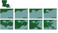
Southeastern Louisiana is drowning at the rate of one football field per hour, totaling up to sixteen square miles annually. In just eighty years, sea level rise, fossil fuel extraction, and having too few wetlands separating the Gulf from the flood protection levee systems have caused some 2,000 square miles of Louisiana’s coastal landscape to sink into the Gulf of Mexico. The issues facing Louisiana’s southeastern coast pose a threat to American energy and economic stability. A $50 billion, 50-year coastal restoration plan, formulated in 2007, is yet to be accepted and funded, but experts note that if sea-level rise is as bad as the worst case scenario, several projects at the heart of the restoration plan would become infective.
-
-
Debate over California’s Salton Sea rescue plan coming to a head
The California State Water Resources Control Board (SWRCB) is currently reviewing a plan to arrest the deterioration of the Salton Sea, a shallow, saline lake which runs along the state’s Imperial and Coachella valleys above the San Andreas Fault. The Salton Sea was inadvertently created by engineers with the California Development Company when they cut off a series of canals in an effort to manage river flooding between 1904 to 1906. It has since been a popular vacation destination.
-
The long view
How Climate Change Will Affect Conflict and U.S. Military Operations
“People talk about climate change as a threat multiplier,” said Karen Sudkamp, an associate director of the Infrastructure, Immigration, and Security Operations Program within the RAND Homeland Security Research Division. “But at what point do we need to start talking about the threat multiplier actually becoming a significant threat all its own?”