-
Atmospheric rivers, cloud-creating aerosol particles, and California water situation
In the midst of the California rainy season, scientists – using aircraft, research vessel, and ground stations — are embarking on a field campaign designed to improve the understanding of the natural and human-caused phenomena that determine when and how the state gets its precipitation. They will do so by studying atmospheric rivers, meteorological events that include the famous rainmaker known as the Pineapple Express. Atmospheric rivers, which produce up to 50 percent of California’s precipitation and can transport 10-20 times the flow of the Mississippi River.
-
-
Louisiana governor seeks to uphold law blocking wetlands damages lawsuit
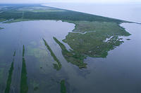
Louisiana governor Bobby Jindal (R) has asked the Louisiana Supreme Court to uphold the constitutionality of Act 544, a law passed to block the wetlands damages lawsuit levied by the East Bank Levee Authority against more than eighty oil, gas, and pipeline companies for the damage their operations have inflicted on Louisiana wetlands. On 3 December of last year by the 19th Judicial District Court Judge Janice Clark declared the law unconstitutional.
-
-
FEMA paid cities for damages that should have been covered by insurance: Audit
Though the hurricanes which ravaged much of Florida in 2004 and 2005 are 10-year-old events, the Federal Emergency Management Agency (FEMA) is still dealing with the damages and fallout, and a new audit reveals that the agency may have paid for city damages that should have been covered by insurance companies. It is estimated that $177 million in payments may be at issue. The audit also found that FEMA improperly waived the need for hurricane-stricken communities to buy insurance to protect against future events, meaning that the agency and taxpayers may have to pay to cover future damages that they would not have had to cover if the procedures had been followed. More specifically, the audit found that FEMA stands to lose roughly $1 billion in future damage costs because of this.
-
-
Sea level rise has been more rapid than previously understood: Study
The acceleration of global sea level change from the end of the twentieth century through the last two decades has been significantly swifter than scientists thought, according to a new Harvard study. The study shows that calculations of global sea-level rise from 1900 to 1990 had been overestimated by as much as 30 percent. The report, however, confirms estimates of sea-level change since 1990, suggesting that the rate of change is increasing more rapidly than previously understood.
-
-
Rivers of meltwater on Greenland’s ice sheet contribute to rising sea levels
As the largest single chunk of melting snow and ice in the world, the massive ice sheet that covers about 80 percent of Greenland is recognized as the biggest potential contributor to rising sea levels due to glacial meltwater. Until now, however, scientists’ attention has mostly focused on the ice sheet’s aquamarine lakes — bodies of meltwater that tend to abruptly drain — and on monster chunks of ice that slide into the ocean to become icebergs. A new study reveals, however, a vast network of little-understood rivers and streams flowing on top of the ice sheet that could be responsible for at least as much, if not more, sea-level rise as the other two sources combined.
-
-
Scientists try to find cause of early January Texas quakes
A scientific team is adding twenty-two seismographs to an area in northern Texas after thirteen small earthquakes rattled the region on 1 January and on throughout the week. Despite the ongoing concern and the search for the cause of the tremors, the research team reassured residents that those worried about lots of little events leading to a bigger one can probably rest easy. “There are no large active faults in Texas, just smaller-type faults,” said geophysicist John Bellini. “Because of that, it’s not likely that Texas would have a large earthquake.
-
-
Coastal communities preparing for the next high tide
The USC Sea Grant program is continuing the work it started three years ago to help coastal communities in Southern California incorporate “resilience” into their planning for adaptation to rising sea levels and climate change. From Santa Barbara to San Diego, Sea Grant works with researchers and community leaders to help governments, businesses and community groups know the resources available to help them plan ahead. The Sea Grant vulnerability report for the city was based on a pilot version of the USGS modeling system, called CoSMoS 1.0, which makes predictions of storm-induced coastal flooding based on a moderately severe storm that occurred in the region in January 2010. It models storm-driven sea level rise for two future climate scenarios, which can help emergency responders and coastal planners anticipate storm hazards and make plans to allocate resources to deal with them.
-
-
Ireland increasingly worried about effects of sea-level rise on coastal communities
In recent years, coastal authorities in Ireland have grown increasingly concerned about the effects of climate change on the Irish coastline. In the northern counties, up to 3.5 percent of the entire land area could be underwater, and low-lying cities of Cork, Dublin, Belfast, and Galway will find it almost impossible to defend against storm surges and sea level rise. Experts say it will cost at least €5 billion to protect Ireland’s most populated cities.
-
-
Fracking in Ohio confirmed as cause of rare “felt” earthquake
In March 2014, a series of five recorded earthquakes, ranging from magnitude 2.1 to 3.0, occurred within one kilometer (0.6 miles) of a group of oil and gas wells operated by Hilcorp Energy, which was conducting active hydraulic fracturing operations at the time. Due to the proximity of a magnitude 3.0 event near a well, the Ohio Department of Natural Resources (ODNR) halted operations at the Hilcorp well on 10 March 2014. A new study links the March 2014 earthquakes in Poland Township, Ohio to hydraulic fracturing that activated a previously unknown fault. The induced seismic sequence included a rare felt earthquake of magnitude 3.0.
-
-
N.C. panel releases much-anticipated draft of sea-level rise forecast
Last week, the North Carolina Coastal Resources Commissionadvisory science panel released its draft copyof sea-level rise forecast for several regions along the North Carolina coast over the next thirty years. The state’s General Assembly rejected a similar report in 2010 after coastal developers and some Republican legislators claimed that the report was biased. A 2012 state law bans state agencies from taking any action based on the sea-level forecast until 1 July 2016.Analysts say that the18-months wait untilstate agencies can take sea-level rise forecast into account may put North Carolina behind other East Coast states which have already begun to adapt to sea-level rise by updating their zoning laws, construction elevation requirements, and major infrastructure plans.
-
-
Miami Beach pushing beachfront development -- collecting storm-water fees to fight sea-level rise
City planners and real estate developers in Miami Beach are fight the threat of climate change by continuing to encourage the development of new beachfront properties, including hotels and residential condos. Revenue from real estate taxes and fees will fund a $300 million storm-water project. Florida has no income tax, and much of South Florida’s public infrastructure projects are supported by property taxes. By 2020, Miami Beach will have built eighty new storm pumps which will collect and remove up to 14,000 gallons of seawater per minute back into Biscayne Bay.
-
-
Major U.S. cities brace for climate change impacts
American cities facing eroding coastlines and greater risk of storm damage are instituting new policies, adopting new approaches, and establishing new practices in order to be better prepared for the impact of climate change in the coming decades. There are different approaches, but 2014 marks a year of major commitments to practices aiming to control and mitigate future climate change impacts on the country’s urban centers.
-
-
Proposed Salt Lake City prison at risk from tsunami waves in event of earthquake
Salt Lake City mayor Ralph Becker is warning Utah state leaders that if a proposed prison is constructed on the shores of the Great Salt Lake, it could be at risk of a major tsunami damage in the event of an earthquake in the region. “It all sounds far-fetched that a big earthquake could result in tsunami-like waves on the lake, but it is possible. Basically, I think it is a terrible idea to put a prison there or an industrial park or any other major development because of the hazard from the lake,” says one seismologist.
-
-
Breaking up asteroids
NASA is currently planning an Asteroid Redirect Mission (ARM) as part of America’s next human spaceflight enterprise. Understanding the origins of asteroid sizes — and then identifying a good one for an astronaut to recover — are prime U.S. goals. Researchers found that for asteroids about one hundred meters in diameter, collisions are not the primarily cause of break ups — rapid rotation is.
-
-
Ten years after the Boxing Day tsunami, are coasts any safer?
Ten years ago we witnessed one of the worst natural disasters in history, when a huge earthquake off the coast of Sumatra triggered a devastating tsunami which swept across the Indian Ocean. An estimated 230,000 people lost their lives, and 1.6 million people lost their homes or livelihoods. The impact was greatest in northern Sumatra because of its proximity to the earthquake. Catastrophic shaking was followed within minutes by the full force of the tsunami. Thousands of people were also killed in distant countries, where the earthquake could not be felt. If they had received a warning of the approaching tsunami, they could have moved inland, uphill or out to sea, and survived. Future tsunami disasters are inevitable, but with better technology, education and governance we can realistically hope that a loss of life on the scale of the 2004 tsunami disaster will not happen again.
-
- All
- Regional
- Water
- Biometrics
- Borders/Immig
- Business
- Cybersecurity
- Detection
- Disasters
- Government
- Infrastructure
- International
- Public health
- Public Safety
- Communication interoperabillity
- Emergency services
- Emergency medical services
- Fire
- First response
- IEDs
- Law Enforcement
- Law Enforcement Technology
- Military technology
- Nonlethal weapons
- Nuclear weapons
- Personal protection equipment
- Police
- Notification /alert systems
- Situational awareness
- Weapons systems
- Sci-Tech
- Sector Reports
- Surveillance
- Transportation
Advertising & Marketing: advertise@newswirepubs.com
Editorial: editor@newswirepubs.com
General: info@newswirepubs.com
2010-2011 © News Wire Publications, LLC News Wire Publications, LLC
220 Old Country Road | Suite 200 | Mineola | New York | 11501
Permissions and Policies
Editorial: editor@newswirepubs.com
General: info@newswirepubs.com
2010-2011 © News Wire Publications, LLC News Wire Publications, LLC
220 Old Country Road | Suite 200 | Mineola | New York | 11501
Permissions and Policies