-
California dams plagued by seismic concerns
Half of Santa Clara County, California’s reservoirs cannot be filled to their full capacity due to seismic concerns; engineering tests revealed that in the event of a major earthquake the dam could slump sending a deadly tidal wave across densely populated communities; seismic retrofit costs to the county’s dam are estimated at $150 million; with the reduced capacity, the county’s dams must be maintained at 67 percent of its total capacity and cannot store more water in preparation for future droughts; the lost capacity could provide water for 280,000 people for a year
-
-
Megastorm could devastate California, not just earthquakes
A team of over 100 scientists, engineers, and emergency planners are urging California disaster planning officials to prepare for megastorms; the team projected that a catastrophic megastorm could decimate California with massive landslides and flooding; the findings were based on geological evidence of such powerful storms that occur every 300 years; the last megastorm occurred in 1861 and left the Sacramento Valley an “inland sea”
-
-
Aussies flee more flooding
Flood water in northern Australia now cover an area larger than Germany and France combined; in addition to Queensland, large parts of the state of Victoria are now under water; around sixty towns across an area larger than Denmark to the north-west of the state capital, Melbourne, have been hit by floods as heavy rain from recent weeks makes its way across broad floodplains to the Murray River; the estimated damage in hard-hit Queensland now stands at US$19.8 billion
-
-
Who is the culprit in the Queensland floods: man or nature?
Climate change may contribute to the intensification of natural disasters, but the major drivers of the rapidly rising costs of natural disasters — in Australia and around the world — are societal changes such as increases in population, wealth, and inflation, not climate change; the only way to reduce the scale of future disasters in Australia are risk-informed land planning policies with risks appropriately priced by an active insurance market; in simple terms, for flood and bushfire, this means an end to unmanaged development of flood plains or within bushlands
-
-
Mexico City's sinking is worsening
Scientists are alarmed by the extent to which Mexico City has sunk; over the last 100 years, parts of the city have sunk as much as forty-two feet — and sections of the city sink as much as eight inches a year; the sinking has caused the city’s sewage system to back up resulting in dangerous floods; the sinking is the result of water being pumped from the aquifer directly below the city more quickly than it is being replenished; Mexico City is built in the middle of Lake Texcoco, which has been drained
-
-
Economic, infrastructure damage of floods in Australia, Brazil staggering
The floods in Australia and Brazil demonstrate how vulnerable societies are to the ravages of nature; the floods in Brazil have caused damage estimated at $1.2 billion; the Australia flooding could prove to be the most costly in the country’s history, already topping $5 billion before the waters reached Brisbane last week; the waters have ruined the agriculture industry in many areas of the country and when including the lost production value of crops and other goods, damages rise to almost $30 billion
-
-
Brisbane under water
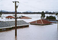
Brisbane, a city of two million and Australia’s third largest, is flooded; roads are inundated, railway lines have been cut, and sewage is spreading into the waters; dozens of suburbs are under three meters of waters, with some factories and homes only visible by their roofs; more than 100,000 properties had their power cut as a precaution against flooding of electricity substations; the worst affected area was the town of Toowoomba, west of Brisbane, where residents described an 8-meter “instant inland tsunami” ripping through the streets on Monday; the flood zone in northern Australia now covers are larger than Germany and France combined
-
-
Aussie "inland tsunami" now threatens Brisbane
The flood zone in northern Australia covers an area larger than France and Germany combined; incessant rain and wide-spread floods have destroyed infrastructure and severely hampered economic activity; the worst is yet to come: Brisbane river has broken its banks, sparking fears that the city — Australia’s third largest and home to two million people - will be flooded by Thursday; public health experts fear that outbreaks of Ross river virus — a debilitating disease transmitted by mosquitoes, which is endemic in Queensland — will increase
-
-
World Bank: Coastal cities in Asia face devastating floods
Thirteen of the twenty largest cities in the world are located on the coast, with more than a third of the world’s population living within 100 miles of a shoreline; a World Bank report finds that Asia’s major coastal cities will experience more devastating floods; damage due to flooding could be as high as 6 percent of regional GDP in 2050; developing cities will be most heavily affected; the report urges the threatened cities immediately to begin developing and implementing long-term plans to harden critical infrastructure to withstand and mitigate the effects of increased flooding
-
-
New spacecraft to help break the climate debate gridlock
NASA plans to settle the climate debate with a fleet of Earth-orbiting spacecraft keeping tabs on the planet’s changing climate; the fleet has two tasks: first: take the total amount of energy coming to Earth from the sun, subtract what gets reflected back or re-radiated from particles in the atmosphere, and see what you have left; if more energy is coming in than going out, it is getting hotter; second: figure out what fraction of these atmospheric particles stems from natural phenomena, such as wind-blown dust and volcanic eruptions, and what is coming from things we can control — our industrial processes, business pursuits, and recreational pass-times
-
-
Floods wreak havoc on Queensland infrastructure, threaten Aussie economy
Queensland is Australia’s largest coal exporter and accounts for about 20 percent of the nation’s A$1.28 trillion economy; the state’s worst in fifty years have forced the evacuation of 4,000 people and affected about a million square kilometers, or an area the size of France and Germany combined; it may cost more than A$5 billion to repair the damage the deluge has caused; Australia had its third-wettest year on record during 2010; the rain has destroyed cotton crops, halted coal deliveries, shut mines, and prompted producers including BHP Billiton Ltd. and Rio Tinto Group to declare force majeure, a legal clause allowing them to miss contracted deliveries
-
-
California prepares for major seismic event
Scientists are growing more wary about the potential for a major seismic event in California; earthquake trends show that intervals between such events have been as short as 45 years to as long as 145 years; considering that it has been 154 years since the last major quake, the San Francisco Bay Area, Delta Region, and Central Valley prepare for the worst
-
-
Recycled Haitian concrete safe, strong, cheap
Nearly a year after the 7.0 magnitude earthquake, most of the damaged areas of Haiti are still in ruins; researchers find that concrete and other debris in Port-au-Prince could be safely and inexpensively recycled into strong new construction material which meets or exceeds the minimum strength standards used in the United States
-
-
Australian floods spread to forty towns, threaten Great Barrier Reef
The floods in Australia continue to spread; forty towns have been flooded so far, affecting 200,000 people; as tons of toxic sludge are being washed into the sea, the famous Great Barrier Reef is now threatened; economists say the disaster could potentially shave about 0.5 percent off Australia’s annual GDP; snakes and marauding crocodiles are among the hazards for the besieged residents of steamy Queensland state, along with disease-carrying mosquitoes and the possibility of looting
-
-
Engineers develop more earthquake-resistant building designs
Virginia Tech researchers are developing a next generation of design criteria for buildings located in geographic regions where earthquakes are known to occur, either rarely or frequently; in the future, structural engineers will base their designs on the concepts of Performance Based Earthquake Engineering (PBEE), where the objective is to control damage and provide life-safety for any size of earthquake that might occur
-
- All
- Regional
- Water
- Biometrics
- Borders/Immig
- Business
- Cybersecurity
- Detection
- Disasters
- Government
- Infrastructure
- International
- Public health
- Public Safety
- Communication interoperabillity
- Emergency services
- Emergency medical services
- Fire
- First response
- IEDs
- Law Enforcement
- Law Enforcement Technology
- Military technology
- Nonlethal weapons
- Nuclear weapons
- Personal protection equipment
- Police
- Notification /alert systems
- Situational awareness
- Weapons systems
- Sci-Tech
- Sector Reports
- Surveillance
- Transportation
Advertising & Marketing: advertise@newswirepubs.com
Editorial: editor@newswirepubs.com
General: info@newswirepubs.com
2010-2011 © News Wire Publications, LLC News Wire Publications, LLC
220 Old Country Road | Suite 200 | Mineola | New York | 11501
Permissions and Policies
Editorial: editor@newswirepubs.com
General: info@newswirepubs.com
2010-2011 © News Wire Publications, LLC News Wire Publications, LLC
220 Old Country Road | Suite 200 | Mineola | New York | 11501
Permissions and Policies