First respondersKnow when to go: a new way to keep firefighters safe from harm
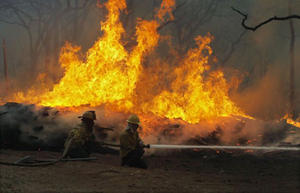
For a firefighter, knowing when it’s time to evacuate can be the difference between life and death. But that can be a difficult call to make when you’re trying to protect life, property and resources while battling wildfires in arduous weather and terrain. Whether working at the fire’s edge or creating a fire break far from the front, firefighters must maintain situational awareness and monitor impending threats to their safety. When firefighters are unable to properly recognize risks, or they underestimate conditions, the results can be tragic.
Survival often depends on knowing when to withdraw // Source: vietbao.vn
For a firefighter, knowing when it’s time to evacuate can be the difference between life and death. But that can be a difficult call to make when you’re trying to protect life, property and resources while battling wildfires in arduous weather and terrain.
In a recent article published in International Journal of Wildland Fire, we present a new way to help firefighters “know when to go.” Whether working at the fire’s edge or creating a fire break far from the front, firefighters must maintain situational awareness and monitor impending threats to their safety. When firefighters are unable to properly recognize risks, or they underestimate conditions, the results can be tragic.
Knowing when to evacuate relies on the idea of a trigger — when a condition is reached, a specific set of actions should occur.
A spatial trigger could be set at a ridgeline. If a fire reaches that ridgeline, firefighter evacuation to a safe area would be triggered.
Our model uses knowledge of fuel, terrain, and predicted weather conditions to set triggers on the landscape before firefighters are deployed, providing a tool that can assist the decision to evacuate and help firefighters avoid being trapped.
We start with the idea of a safety zone. A safety zone is an area where firefighters will not be threatened by the direct impacts of the fire. It is usually a clearing with a diameter several times the expected flame length.
We can calculate the time it should take firefighters to travel to that safety zone based on their assignment. Since there are multiple modes of potential travel, we calculate travel times on foot, by engine, and by bulldozer. Travel time is adjusted for slope, since steep terrain will impede travel.
Once these travel times to safety zones are calculated, we use fuel, terrain, and forecast weather conditions to model the fire spread rate. By creating a network of fire spread rates, we can calculate when the fire could potentially reach the evacuation route and the safety zone.
A “trigger buffer” can then be created that surrounds the evacuation route and safety zone. If the trigger buffer is crossed by the fire, it’s time to evacuate.