-
Protecting the U.S. power grid from cyberattacks
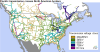
In the first half of Fiscal Year 2015, the Industrial Control Systems Cyber Emergency Response Team (ICS-CERT), part of the Department of Homeland Security, responded to 108 cyber incidents impacting critical infrastructure in the United States. As in previous years, the energy sector led all others with the most reported incidents. Researchers from Florida International University’s (FIU) College of Engineering and Computing have teamed up with four other universities and a utility company to help safeguard the nation’s power utilities from cyberattacks.
-
-
U Warwick, U.K. National Grid expand £1.5 million partnership
Last week the University of Warwick and the U.K. National Grid have signed a Memorandum of Understanding (MoU) to extend the strategic alliance they have operated for last two years. To date that alliance has engaged in over £1.5 million worth of research and student scholarships in areas such as electricity transmission asset management, gas transmission, micro-tunneling, and cyber security.
-
-
Sea level rise dooms Miami, New Orleans
Say goodbye to Miami and New Orleans. No matter what we do to curb global warming, these and other beloved U.S. cities will sink below rising seas, according to a new study. “In our analysis, a lot of cities have futures that depend on our carbon choices but some appear to be already lost,” says one of the study’s authors. “And it is hard to imagine how we could defend Miami in the long run.” An online tool shows which U.S. cities may face “lock-in dates beyond which the cumulative effects of carbon emissions likely commit them to long-term sea-level rise that could submerge land under more than half of the city’s population,” said the study.
-
-
NSF awards $74.5 million to 257 interdisciplinary cybersecurity research projects
The NSF the other day announced the awarding $74.5 million in research grants through the NSF Secure and Trustworthy Cyberspace (SaTC) program. In total, the SaTC investments include a portfolio of 257 new projects to researchers in thirty-seven states. The largest, multi-institutional awards include research better to understand and offer reliability to new forms of digital currency known as cryptocurrencies, which use encryption for security; invent new technology to broadly scan large swaths of the Internet and automate the detection and patching of vulnerabilities; and establish the “science of censorship resistance” by developing accurate models of the capabilities of censors.
-
-
Cyber vulnerability of civil nuclear facilities underestimated
The risk of a serious cyberattack on civil nuclear infrastructure is growing, as facilities become ever more reliant on digital systems and make increasing use of commercial off-the-shelf software, according to a new report. The report finds that the trend to digitization, when combined with a lack of executive-level awareness of the risks involved, means that nuclear plant personnel may not realize the full extent of their cyber vulnerability and are thus inadequately prepared to deal with potential attacks.
-
-
Water security test bed to focus on bolstering municipal water security
Water is the foundation for life. People use water every single day to meet their domestic, industrial, agricultural, medical, and recreational needs. After the September 2001 terrorist attacks, water system security became a higher priority in the United States. The Water Security Test Bed (WSTB) at Idaho national Laboratory can be used for research related to detecting and decontaminating chemical, biological, or radiological agents following an intentional or natural disaster. The WSTB will focus on improving America’s ability to safeguard the nation’s water systems, and respond to contamination incidents and to natural disasters.
-
-
Climate change will soon make atolls in the Pacific, Indian oceans uninhabitable
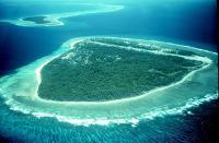
More than half a million people live on atolls throughout the Pacific and Indian Oceans. A new study shows that the combined effect of storm-induced wave-driven flooding and sea level rise on island atolls may be more severe and happen sooner than previous estimates of inundation predicted by passive “bathtub” modeling for low-lying atoll islands, and especially at higher sea levels forecasted for the future due to climate change.
-
-
Eight dead, thousands stranded as South Carolina hit by “once in a millennium” floods
In what Governor Nikki Haley described as a “once-in-a-millennium” flood, a downpour has inundated large parts of South Carolina, causing at least eight deaths. By early Sunday, the storm had dumped more than eighteen inches of rain in parts of central South Carolina, and the state climatologist forecast another 2 to 6 inches through Monday as the rainfall began to weaken. After state police and emergency crews had to rescue hundreds of motorists and passengers from vehicles which stalled in high water, Haley announced all interstate highways in and around Columbia would be closed, and ordered to deployment of 600 national guardsmen to help with rescues and evacuations.
-
-
Flood risk for New York City, New Jersey coast rising
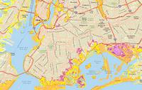
Flood risk for New York City and the New Jersey coast has increased significantly during the last 1,000 years due to hurricanes and accompanying storm surges. For the first time, researchers compared both sea-level rise rates and storm surge heights in prehistoric and modern eras and found that the combined increases of each have raised the likelihood of a devastating 500-year flood occurring as often as every twenty-five years. “A storm that occurred once in seven generations is now occurring twice in a generation,” says one of the researchers. What does that mean for residents along the New York/New Jersey coast? “An extra 100,000 people flooded in the region during Hurricane Sandy who would not have flooded if sea level had not been rising,” the researcher says of the 2012 storm.
-
-
Partnering to build climate change resiliency
South Florida ranks as the world’s most vulnerable urban region because of the large number of assets exposed to the effects of sea level rise. To build climate change resiliency, the Federal Emergency Management Agency (FEMA) partnered with Florida International University (FIU) to provide local community leaders with the knowledge and tools to assess and improve their capabilities to prevent, mitigate, respond to, and recover from climate impacts, including sea level rise, drought and wildfires, heatwaves, floods, powerful storms, and other hazards.
-
-
Rising seas, bigger storms may greatly magnify U.S. East Coast floods
Over the past century, the East Coast has seen sea-level rise far above the 8-inch global average — up to a foot in much of the Mid-Atlantic and Northeast, including New York City. Many studies predict that future sea-level rise along the U.S. Atlantic and Gulf coasts will increase flooding. Others suggest that the human-caused warming driving this rise will also boost the intensity and frequency of big coastal storms. Up to now, though, these two hazards have been assessed mostly in isolation from each other. Now, a new study quantifies how they could interact to produce alarming spikes in the combined height and duration of flooding. It projects that coastal flooding could possibly shoot up several hundredfold by 2100, from the Northeast to Texas.
-
-
El Niño, La Niña will exacerbate coastal hazards across entire Pacific
The projected upsurge of severe El Niño and La Niña events will cause an increase in storm events leading to extreme coastal flooding and erosion in populated regions across the Pacific Ocean, according to a multi-agency study. The impact of these storms is not presently included in most studies on future coastal vulnerability, which look primarily at sea level rise. New research data, from forty-eight beaches across three continents and five countries bordering the Pacific Ocean, suggest the predicted increase will exacerbate coastal erosion irrespective of sea level rise affecting the region.
-
-
Grid Game teaches students about electric grid complexity, resilience
Outages caused by severe weather cost the U.S. economy an average of $18 billion to $33 billion a year. The hits come from lost output and wages, spoiled inventory, delayed production, and damage to the electric grid. Engineers and teachers have developed a Grid Games — desktop simulation which allows players to keep load and generation in balance. “Red Team” participants can even mount financial and cyberattacks in real time, making the game even more interesting.
-
-
Burning world’s remaining fossil fuel could cause 60-meter sea level rise
New work from an international team including Carnegie’s Ken Caldeira demonstrates that the planet’s remaining fossil fuel resources would be sufficient to melt nearly all of Antarctica if burned, leading to a 50- or 60-meter (160- to 200-foot) rise in sea level. Because so many major cities are at or near sea level, this would put many highly populated areas where more than a billion people live under water, including New York City and Washington, D.C. The researchers found that if global warming did not exceed the 2 degree Celsius target often cited by climate policymakers, Antarctic melting would cause sea levels to rise only a few meters and remain manageable. But greater warming could reshape the East and West ice sheets irreparably, with every additional tenth of a degree increasing the risk of total and irreversible Antarctic ice loss.
-
-
Beyond data theft: Next phase of cyber intrusions will include destruction, manipulation of data
James Clapper, director of U.S. intelligence, and other senior intelligence officers, have warned Congress that the next phase of escalating online data theft will likely involve the manipulation of digital information. Clapper on Wednesday told lawmakers on the House Intelligence Committee that a “cyber Armageddon,” in which a digitally triggered damage to physical infrastructure results in a series of catastrophic events, is less likely than “cyber operations that will change or manipulate data.” Leaders of the U.S. intelligence community told lawmakers that the manipulation or destruction of data would undermine confidence in data stored on or accessible through U.S. networks, engendering an uncertainty which could jeopardize U.S. military situational awareness and undermine business activity.
-
- All
- Regional
- Water
- Biometrics
- Borders/Immig
- Business
- Cybersecurity
- Detection
- Disasters
- Government
- Infrastructure
- International
- Public health
- Public Safety
- Communication interoperabillity
- Emergency services
- Emergency medical services
- Fire
- First response
- IEDs
- Law Enforcement
- Law Enforcement Technology
- Military technology
- Nonlethal weapons
- Nuclear weapons
- Personal protection equipment
- Police
- Notification /alert systems
- Situational awareness
- Weapons systems
- Sci-Tech
- Sector Reports
- Surveillance
- Transportation
Advertising & Marketing: advertise@newswirepubs.com
Editorial: editor@newswirepubs.com
General: info@newswirepubs.com
2010-2011 © News Wire Publications, LLC News Wire Publications, LLC
220 Old Country Road | Suite 200 | Mineola | New York | 11501
Permissions and Policies
Editorial: editor@newswirepubs.com
General: info@newswirepubs.com
2010-2011 © News Wire Publications, LLC News Wire Publications, LLC
220 Old Country Road | Suite 200 | Mineola | New York | 11501
Permissions and Policies