-
Pipeline replacement programs are effective
Aging infrastructure, including roads, bridges, and natural gas and water mains, is an increasing concern. In 2011 the U.S. Pipeline and Hazardous Materials Safety Administration issued a call to action to accelerate the repair, rehabilitation, and replacement of the highest-risk pipeline infrastructure. Invisible gas leaks from aging or damaged pipelines cost U.S. consumers billions of dollars every year, contribute to global warming and, in rare cases, cause dangerous explosions. Pipeline replacement programs in cities, however, can cut natural gas leaks by 90 percent, a new study finds. “The surprise wasn’t that replacement programs worked,” said the study’s lead author. “It was that they worked so well.”
-
-
NOAA: El Niño may accelerate nuisance flooding
Nuisance flooding causes public inconveniences such as frequent road closures, overwhelmed storm water systems, and compromised infrastructure. The extent of nuisance flooding depends on multiple factors, including topography and land cover. According to a new NOAA report issued yesterday, many mid-Atlantic and West Coast communities could see the highest number of nuisance flooding days on record through April due to higher sea levels and more frequent storm surge, compounded by the strengthening El Niño, which is likely to continue into the spring. These communities may experience a 33 to 125 percent increase in the number of nuisance flooding days, the report said.
-
-
Army Corps of Engineers risk reduction projects prevent $13.3 billion in flood damages
May 2015 was the wettest month on record for both Texas and Oklahoma, and set numerous records throughout the region. Continuing rains from Tropical Storm Bill in June resulted in Army Corps of Engineers flood risk reduction reservoirs and other systems put through a rigorous test to hold the floodwaters and protect local communities and downstream areas. According to recent calculations by U.S. Army Corps of Engineers officials with the Southwestern Division in Dallas, the Corps flood risk reduction projects in the south central and southwestern United States prevented an estimated $13.3 billion in damages to local communities and infrastructure during the May-June 2015 flood event.
-
-
Sea level rise: NASA watching waters rise right outside the front door – pt. 2
The rate of sea level rise is faster now than at any time in the past 2,000 years, and that rate has doubled in the past two decades. If ice sheets in Greenland and Antarctica continue to melt as quickly as current measurements indicate, those numbers could become 21 to 24 inches by the 2050s and 43 to 49 inches by the 2080s. Half to two-thirds of NASA’s infrastructure and assets stand within sixteen feet of sea level, so NASA is facing the same problem faced by about 55 to 60 percent of U.S. citizens, who live in counties touching the Atlantic or Pacific Ocean, the Gulf of Mexico, or the Great Lakes. Across the space agency, from lab manager to center director to NASA administrator, people will have continually to ask the question: is it time to abandon this place and move inland? It is a question everyone with coastal property in America will eventually have to answer.
-
-
Strategic alliance to deliver behavioral analysis cybersecurity to market
Ernst & Young LLP and Los Alamos National Laboratory have formed a strategic alliance to deliver what they describe as some of the most advanced behavioral cybersecurity tools available to the commercial market. The alliance comes at a watershed moment when increasingly sophisticated cyberattacks are inflicting significant economic, social, and even political damage to U.S. organizations. The tools developed by Los Alamos and delivered to the private sector by Ernst & Young LLP can help counter these threats by detecting them before they do deep and lasting damage.
-
-
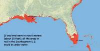
NASA watching waters rise right outside the front door – pt. 1

For the past two centuries, two trends have been steady and clear around the United States. Sea level has been rising, and more people have been moving closer to the coast. As the ocean has warmed, polar ice has melted, and porous landmasses have subsided, global mean sea level has risen by eight inches since 1870. The rate of sea level rise is faster now than at any time in the past 2,000 years, and that rate has doubled in the past two decades. If ice sheets in Greenland and Antarctica continue to melt as quickly as current measurements indicate, those numbers could become twenty-one to twenty-four inches by the 2050s and forty-three to forty-nine inches by the 2080s. About 55 to 60 percent of U.S. citizens live in counties touching the Atlantic or Pacific Ocean, the Gulf of Mexico, or the Great Lakes. A recent study by business and finance leaders found that $66 billion to $106 billion worth of coastal property is likely to sit below sea level by 2050. The nation’s problem is also NASA’s problem, because half to two-thirds of NASA’s infrastructure and assets stand within sixteen feet of sea level.
-
-
Power safety in data centers
Power and thermal management have become a critical priority in data centers, which can use as much electricity as a small town. Energy and power vulnerabilities pose serious security threats to data centers, but so far little has been done to address these issues. A DHS grant will allow researchers to investigate energy and power safety in data centers.
-
-
Protecting Earth from asteroid impact

Asteroids approaching our planet travel at up to thirty kilometers per second. At that speed, a body with a diameter of only 100 meters could have major consequences for our civilization. Scientists cannot say when the next major asteroid will hit Earth, but it is certain that it will happen sometime in the future. An international team of researchers is hoping to head the next one off. It is a major EU-funded initiative that pulls together all the latest science and combines laboratory experiments with computer modelling work. The ultimate aim of this effort is to develop some definitive plan to knock massive asteroids out of their Earth-bound orbit.
-
-
Smaller cities in developing world unprepared for disaster
While many planners focus on the threat of natural disasters to major metropolises around the world, a new study shows smaller cities are often even less equipped to handle such catastrophes. In India, where his study was focused, the number of people living in such cities grew from 170 to 227 million over the past twenty years. This, however, has not prompted disaster planning experts to focus on how to safeguard these cities from the risk of floods, earthquakes, mudslides, and tidal waves. Many of those threats are even greater now due to climate change.
-
-
Rare but predictable storms could pose big hazards
Researchers at Princeton and MIT have used computer models to show that severe tropical cyclones could hit a number of coastal cities worldwide that are widely seen as unthreatened by such powerful storms.
The researchers call these potentially devastating storms Gray Swans in comparison with the term Black Swan, which has come to mean truly unpredicted events that have a major impact. Gray Swans are highly unlikely, the researchers said, but they can be predicted with a degree of confidence. The researchers examined potential storm hazards for three cities: Tampa, Florida; Cairns, Australia; and Dubai, United Arab Emirates.
-
-
Project develops techniques for tackling asteroids, space debris

Asteroids and space debris represent a significant hazard for space and terrestrial assets; at the same time asteroids also represent an opportunity. In recent years it has become clear that the increasing population of space debris could lead to catastrophic consequences in the near term. The STARDUST project — the first and only network to provide training on space debris and asteroids — was established to address this growing problem.
-
-
A melting Arctic demands more – not less – research on earth science
The Arctic is melting rapidly. Who cares? Anyone who is concerned about the rising price of food, lives near the coast, shoveled snow all winter, can’t water their lawn anymore, pays a bigger premium now for property insurance, or enjoys eating seafood. Did we leave anyone out? Apparently so, yet this group of people should care as much as anyone. The House of Representatives earlier this year slashed NASA’s earth sciences research budget, which funds much of the research U.S. scientists do on the Arctic. Scientific research is not a luxury to be indulged. It is an essential contributor to our national well-being, helping us avoid costly mistakes while finding new ways to improve our security, our economy, and our quality of life. Today, Congress is taking us on a course toward an Arctic legacy of myopia, feebleness, and ignorance. Rather than denying the changes that affect us all, they should be steering our national policies toward scientific excellence and vigorous action on challenges such as Arctic meltdown and its impacts. Nowhere is the evidence clearer; never has the need for research been more urgent. We ignore the Arctic at our peril.
-
-
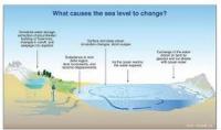
Sea level rise unevenly, which is bad news for some coastal regions
When you fill a sink, the water rises at the same rate to the same height in every corner. This is not the way it works with our rising seas. Tides, winds, and ocean currents play a role in these regional differences, but an increasingly important mover and shaker is the solid Earth itself. Global warming is not just affecting the surface of our world; it is making the Earth move under our feet. These regional differences in sea level change will become even more apparent in the future, as ice sheets melt. For instance, when the Amundsen Sea sector of the West Antarctic Ice Sheet is totally gone, the average global sea level will rise four feet. The East Coast of the United States, however, will see an additional fourteen to fifteen inches above that average.
-
-
Sea-level rise handbook to help land managers, coastal planners, and policy makers
Coastal managers and planners now have access to a new U.S. Geological Survey (USGS) handbook which, for the first time, comprehensively describes the various models used to study and predict sea-level rise and its potential impacts on coasts. The handbook, designed for the benefit of land managers, coastal planners, and policy makers in the United States and around the world, explains many of the contributing factors that account for sea-level change.
-
-
FIU launches Sea Level Solutions Center

With rising seas threatening coastal communities all across the world, Florida International University (FIU) has launched the Sea Level Solutions Center to help people understand, adapt and persevere. FIU says that the center combines expertise in the natural, physical, and social sciences, along with architecture, engineering, computer sciences, law, communications, business, health, and tourism management to develop long-term strategies in the face of rising seas, noting that FIU’s Miami location will be key in advancing the center’s mission. South Florida is particularly vulnerable because of the large number of assets exposed to the effects of sea level rise.
-
- All
- Regional
- Water
- Biometrics
- Borders/Immig
- Business
- Cybersecurity
- Detection
- Disasters
- Government
- Infrastructure
- International
- Public health
- Public Safety
- Communication interoperabillity
- Emergency services
- Emergency medical services
- Fire
- First response
- IEDs
- Law Enforcement
- Law Enforcement Technology
- Military technology
- Nonlethal weapons
- Nuclear weapons
- Personal protection equipment
- Police
- Notification /alert systems
- Situational awareness
- Weapons systems
- Sci-Tech
- Sector Reports
- Surveillance
- Transportation
Advertising & Marketing: advertise@newswirepubs.com
Editorial: editor@newswirepubs.com
General: info@newswirepubs.com
2010-2011 © News Wire Publications, LLC News Wire Publications, LLC
220 Old Country Road | Suite 200 | Mineola | New York | 11501
Permissions and Policies
Editorial: editor@newswirepubs.com
General: info@newswirepubs.com
2010-2011 © News Wire Publications, LLC News Wire Publications, LLC
220 Old Country Road | Suite 200 | Mineola | New York | 11501
Permissions and Policies