Seawalls130-year old seawall protected New Jersey town from Sandy's storm surges
Bay Head and Mantoloking sit side-by-side in Ocean County, facing the ocean. In Bay Head, Sandy flooded 88 percent of the oceanfront homes, with just one oceanfront home destroyed. In Mantoloking, more than half of the oceanfront homes were damaged or destroyed. The reason for the difference between minor structural impacts and widespread destruction: a relatively small coastal obstacle — a forgotten, 1,260-meter seawall, built in 1882 and buried beneath the beach – which reduced potential wave loads by a factor of two.
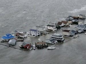
Bay Head escaped devastation that nearby Mantoloking suffered // Source: chips.jp
Picture two residential beach communities on the New Jersey shore: Bay Head and Mantoloking, which sit side-by-side in Ocean County on a narrow barrier island that separates the Atlantic Ocean and Barnegat Bay.
Before Hurricane Sandy landed on 29 October 2012, a motorist traveling north on Ocean Avenue would seamlessly travel through Mantoloking into Bay Head, noticing few changes in residential development, dunes, beaches, and shoreline.
The difference was hidden under the sand.
A Virginia Tech release reports that a forgotten, 1,260-meter seawall buried beneath the beach helped Bay Head weather Sandy’s record storm surges and large waves over multiple high tides, according to a team of engineers and geoscientists led by Jennifer L. Irish, an associate professor of civil and environmental engineering in the College of Engineering at Virginia Tech and an authority on storm surge, tsunami inundation, and erosion.
The stone structure dates back to 1882. Its reappearance surprised many area residents, underscoring the difficulties transient communities have in planning for future threats at their shores, the researchers said.
“It’s amazing that a seawall built nearly 150 years ago, naturally hidden under beach sands, and forgotten, should have a major positive effect under the conditions in which it was originally designed to perform,” said H. Richard Lane, program director in the National Science Foundation’s (NSF) Division of Earth Sciences, which funded the research. “This finding should have major implications for planning, as sea level rises and storms increase in intensity in response to global warming.”
The discovery, now online in the journal Coastal Engineering and slated for the October print edition, illustrates the need for multi-levels of beach protection in oceanfront communities, the researchers said.
“Once we got there, we immediately saw the seawall,” Irish said. “The beach and dunes did their job to a certain point, then, the seawall took over, providing significant dampening of the waves. It was the difference between houses that were flooded in Bay Head and houses that were reduced to piles of rubble in Mantoloking.”
With recovery efforts under way and storms still circulating through the area, Irish and Robert Weiss, an assistant professor of geosciences in the College of Science at Virginia Tech, with Patrick Lynett, an associate professor of civil and environmental engineering at the University of Southern California, documented high water marks, damage, overwash, and breaches of the barrier island.
All oceanfront homes in the two boroughs were damaged, ranging from ground-floor flooding to complete destruction. As measured by water lines on the interior of homes, flooding was similar in both boroughs. The difference was the extent of the storm’s impact.
In Mantoloking, the entire dune almost vanished. Water washed over the barrier spit and opened three breaches of 165 meters, 59 meters, and 35 meters, where the land was swept away. In Bay Head, only the portion of the dune located seaward of the seawall was eroded and the section of dune behind the seawall received only minor local scouring.
The release notes that later, using Google Earth to evaluate aerial images taken two years before and immediately after Hurricane Sandy, the research team evaluated houses, labeling a structure with a different roofline as damaged, one that no longer sits on its foundation as destroyed, and the remaining houses as flooded.
The researchers classified 88 percent of the oceanfront homes in Bay Head as flooded, with just one oceanfront home destroyed. In Mantoloking, more than half of the oceanfront homes were classified as damaged or destroyed.
Despite the immense magnitude and duration of the storm, a relatively small coastal obstacle reduced potential wave loads by a factor of two and was the difference between widespread destruction and minor structural impacts, the researchers said.
“We have a great deal of compassion for the people who have had to endure the devastation of Hurricane Sandy in Bay Head and Mantoloking,” Irish said. “It will have little solace, but we are left with a clear, unintentional example of the need for multiple levels of defense that include hard structures and beach nourishment to protect coastal communities.”
— Read more in Jennifer L. Irish et al., “Buried relic seawall mitigates Hurricane Sandy’s impacts” Coastal Engineering 80(October 2013): 79–82 (http://dx.doi.org/10.1016/j.coastaleng.2013.06.001)