Climate and infrastructureRising seas and coastal risks
Most scientists believe that melt water from glaciers, the Greenland ice sheet, and possibly the West Antarctic ice sheet, along with thermal expansion from warming oceans, will raise sea levels by one-half to one meter (1.6 to 3.2 feet) over the next century and by one meter to two meters (6.5 feet) over the next 200 years; if sea level rises by a meter, “we will see higher tides, higher tidal velocities and tidal inundation every day,” says one expert; “And we’ll have a different shoreline”
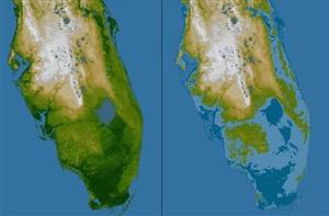
Florida after a 5-meter rise in sea level // Source: greenrightnow.com
Laid back beach communities, fragile wetlands perfect for canoeing or kayaking, and iconic lighthouses come to mind when picturing North Carolina’s coast.
In reality change is the norm along the coast, and although nothing is certain, a warming climate could mean quicker or more significant change over the next few centuries.
Scientists at RENCI and the University of North Carolina at Chapel Hill use the latest modeling techniques and high performance computing power to understand how expected increases in sea level over the next 100 years could affect coastal communities, wildlife and the coastline itself.
Most scientists believe that melt water from glaciers, the Greenland ice sheet, and possibly the West Antarctic ice sheet, along with thermal expansion from warming oceans, will raise sea levels by one-half to one meter (1.6 to 3.2 feet) over the next century and by one meter to two meters (6.5 feet) over the next 200 years.
If that happens, North Carolina’s coast will change dramatically by 2100 or 2200, according to Tom Shay, a UNC-Chapel Hill marine scientist who conducts research with the UNC Institute for the Environment, the UNC department of marine sciences and UNC’s Center for the Study of Natural Hazards and Disasters.
“Some areas of the Outer Banks are only a few meters above sea level now, and there will be an increased tidal range and larger areas inundated by tides,” said Shay. With deeper water in the sounds, storm wave heights would increase as well, he said.
Some land areas, such as parts of the Albemarle and Pamlico peninsulas, will become submerged regardless of storms or high tides, said Shay. Coastal estuaries and the marine and plant life they support also might change due to the influx of higher salinity ocean water.
If sea level rises by a meter, “we will see higher tides, higher tidal velocities and tidal inundation every day,” said Shay. “And we’ll have a different shoreline.”
Shay uses the ADCIRC coastal storm surge modeling software and the SWAN (for Simulating WAves Nearshore) wave modeling software to create new “What If” models, showing how a major storm could affect the coast if sea levels were higher. The work complements work done at RENCI, which uses ADCIRC and SWAN to compute thousands of different possible storm scenarios. The Federal Emergency Management Agency (FEMA) uses the RENCI model output to develop new Flood Insurance Rate Maps (FIRMs) for coastal North Carolina as part of the North Carolina